Image Links to Flash Player:

Its nice to take a good healthy spin & zoom….
This is my first animated mandala, and I am quite pleased with the results.
…I wonder what tomorrow will bring!
| FRONT PAGE |
GEOSPATIAL ART |
DC HISTORY / TIMELINE |
NEWS |
COLONIST |
FOUND MAPS |
FRACTALS |
|
PHOTOGRAPHY |
ANTIQUE |
DESIGN |
VIDEO |
|
CONTACT |
Baltimore Mandala Animated
|| 6/22/2005 || 12:09 am || Comments Off on Baltimore Mandala Animated || ||
Its nice to take a good healthy spin & zoom….
This is my first animated mandala, and I am quite pleased with the results.
…I wonder what tomorrow will bring!
Baltimore Mandala
|| 6/21/2005 || 2:25 pm || Comments Off on Baltimore Mandala || ||

The way the inner harbor is reflected makes this rendering all the more beautiful. There is a small artifact in the center of this image that creates a found focal point that, when printed out, will draw the viewer’s eyes directly to the center of the rendering. This rendering is also the first rendering that I actually made too big! When looking at it’s full 9,000 X 9,000 size, the ground looks slightly fuzzy, yet this is not really a problem! The way I look at it is that I might as well make it as big as possible because I can always shrink it without any degradation. I wonder what I’ll make next!
+ MORE
Ganges Mandala
|| 6/20/2005 || 6:32 pm || Comments Off on Ganges Mandala || ||

Not too shabby :) I like the way the rivers intertwine and form braided streams. This manipulated satellite image is probably the most famous of all the “Earth As Art” collection. It was used for the cover of the Library of Congress flyer as well as the UNEP 2004 Environment Report. I have already sold a print of this one. Its the purple & green!
+ MORE
Jefferson Mandala – 2nd derivative
|| 6/16/2005 || 10:37 pm || Comments Off on Jefferson Mandala – 2nd derivative || ||
911 Mandala
|| 6/14/2005 || 6:57 am || Comments Off on 911 Mandala || ||

Last week I made a rendering I unofficially called “the circle of life,” and this week I’ve made a “circle of death” (above). Last week’s “circle of life” was at the center of the rendering (the GWU Hospital), and this one has the circle of death around the edge of the mandala in the form of the smoke of the World Trade Towers burning. The exact site of the World Trade Center falls just outside of this rendering, in Post 911 Reflection #3 you can see a better, albeit abstracted, view of what New York City looked like September 15th, 2001. While the planes were grounded throughout the United States, the IKONOS satellite was floating silently by recording the space, place, time, and recent history.
Time to go to Capitol Hill to help give a briefing on Geographic Management Systems :)
+ MORE
Jefferson Mandala
|| 6/12/2005 || 6:15 pm || Comments Off on Jefferson Mandala || ||

This rendering marks two significant pinnacles in my geographic artistry.
The biggest step is of making a complete mandala. Before my mandalas were only reflected 4 ways (north, south, east, west) , and now I am achieving reflections of over 8 ways (north-north east, east-north east, etc), which make the final products so much more intricate and in my opinion, far superior to my older maps.
Secondly, the source imagery used for this image was what I’d like to call first derivative geospatial imagery. I have coined term to signify that the source imagery is the first derivation of a previously rendered image. In the image above, I used the rendered imagery from the center of the Mall Quilt as my source imagery for this rendering.
With source imagery’s self-similar design it’s closer to the definition of a fractal. You can zoom into a fractal to infinite, and what I think I’ve created is in effect a geographic fractal where I can take derivatives of renderings and reproject them into infinity. Each derivation will be more reflected and abstract, but I will not lose the spatial resolution so long as the final rendered dimensions are not larger than the source imagery dimensions multiplied by the number of times the source imagery is completely shown.
For example, the source imagery used to make the image above was 6000X6000 pixels, however the image above was rendered at 12000X12000 pixels. I am able to reproject the imagery larger because the actual source imagery is used multiple times within the image and in essence is doubled by the way the source imagery tessellates. Notice how you see a mirror of the Jefferson Memorial (aka 2x for every reflection), the mirroring process allows for the geographic tessellation to not lose spatial resolution when the image is finally rendered. Theoretically, I could cut out the center of this rendering, and use for my next rendering, and it would technically be considered second derivative geospatial imagery…and I might just do that :)
If this is too confusing, I’m sorry. I too am still trying to get my mind around this concept. Regardless, expect some very beautiful renderings in the near future!
View the map’s close-up details using the interactive Flash application called Zoomify
View the Google Map of the Jefferson Memorial in Washington, DC
This map was printed over a million times in newspapers around the world.
+ MORE
Mall Quilt
|| 6/11/2005 || 8:47 pm || Comments Off on Mall Quilt || ||
Jefferson Lenz
|| || 12:15 pm || Comments Off on Jefferson Lenz || ||
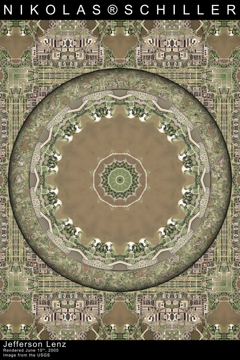
After having Bryce crash while I was setting up the scene, I was very excited to be able to replicate the exact positions of all the objects and to finally start the rendering of this image, albeit over an hour later. This is my first rendering where I’ve gone beyond the standard 4X & 8X reflection to 12X reflection. I am very excited about where this new discovery will take my next set of renderings. Next I am going to attempt to apply this technique to the “Quilt Project“.
As for the Jefferson Lenz itself, there is a slight error in the background where the two objects meet on the seam. Although you cannot see it in the scaled down version above, the two don’t line up perfectly symmetrical- which kinda sucks, but its because I rushed that part of the setup. I was too eager to get the rendering started because of the new central reflections I forgot to see if the background looked perfect or not.
Anyways, I’ll be making another rendering shortly with this imagery…which is actually the same imagery I used for the Washington Monument Lenz, but the way the reflections turned out, you can’t see the Washington Monument, except in the background. So it was going to called Washington Monument Lenz #2, but since you can only see the Jefferson Memorial, I named the rendering accordingly.
Yeah for the weekend!
+ MORE
Baltimore Lenz #3
|| 6/9/2005 || 9:09 pm || Comments Off on Baltimore Lenz #3 || ||

Wow. The artifacts left in the center make this one of the most beautiful renderings yet. It almost looks like a snowflake has appeared inside of the rendering. The time which the original USGS aerial photograph was taken (probably around 3pm) makes the rendering interesting because you can see a boat speeding toward the inner harbor on a cloudless day.
I gave my last rendering, Georgetown Lenz #2, a secondary name, “circle of life,” and I’m giving this one the name, “the inner innner harbor.” It’s partly a joke on the Baltimore’s Inner Harbor, and partly a more personal dimension, of your own inner mind, where one harbors the thoughts of life.
+ MORE
Baltimore Lenz #2
|| 6/8/2005 || 10:04 am || Comments Off on Baltimore Lenz #2 || ||

This rendering was made for a client so it doesn’t have my normal tag on it. It uses the Baltimore Inner Harbor as the focal point which I think the client will appreciate. The next rendering will definitely be either “Baltimore Quilt” or “Baltimore Lenz #3,” the latter will get the same reflection treatment that DC Lenz #4 got. I can’t wait to see how the inner harbor looks reflected! Look at the first Baltimore Lenz….can you imagine what it will look like with 2X more reflection? I am visualizing it right now :)
©2004-2026 Nikolas R. Schiller - Former Colonist of the District of Columbia - Privacy Policy - Fair Use - RSS - Contact
::LAST 51 POSTS::
52 queries. 3.074 seconds.
Powered by WordPress


::THE QUILT PROJECTION::
Square |
Diamond |
Hexagon |
Octagon |
Dodecagon |
Beyond |
::OTHER PROJECTIONS::
The Lenz Project |
Mandala Project |
The Star Series |
Abstract Series |
Memory Series
|
Mother Earth Series
|
|
Misc Renderings
 |
::POPULAR MAPS::
- The Los Angeles Interchanges Series::MONTHLY ARCHIVES::
::LOCATIONS & CATEGORIES::

