The Daily Render

by

A Digital Scrapbook for the Past, Present, and Future

| FRONT PAGE | GEOSPATIAL ART | DC HISTORY / TIMELINE | NEWS | COLONIST | FOUND MAPS | FRACTALS |
| PHOTOGRAPHY | ANTIQUE | DESIGN | VIDEO | | CONTACT |

A Navy Yard Perspective
|| 5/30/2009 || 1:43 pm || 1 Comment Rendered || ||

: rendered at 9,000 X 6,000 :
A Navy Yard Perspective by Nikolas R. Schiller

While on blogging hiatus, I made this map on May 12th, but didn’t post it. I don’t really have any rationale for not posting it except that I wanted to take a month off from blogging to see where my daily visitor threshold was; as in finding how many people visited my website without daily blogging. So in order to ascertain the data, I purposely withheld this entry.

Following up last year’s Artomatic maps, which also featured the area prior to development, I decided to try something a little different. When making this map I spent a lot of time working with the field of view parameters to create the depth of perspective. In the foreground (the lower half) you have a somewhat close-up view of the area around the Navy Yard Metro station in Southeast, Washington, DC and in the upper half you have a larger field of view that appears to stretch out to infinite. The aerial photography was taken in the spring of 2005 before the stadium and subsequent nearby development had been completed. Even if you look at the current Google Maps of the area, the construction of this year’s Artomatic venue had not even began.


View the Google Map of the Navy Yard in Washington, DC, which features newer imagery

: detail of the Navy Yard Metro prior to construction :

View the rest of the map details:

+ MORE


My maps on display at Artomatic 2009
|| 5/29/2009 || 3:10 pm || Comments Off on My maps on display at Artomatic 2009 || ||

Click on the maps to view their respective blog entries


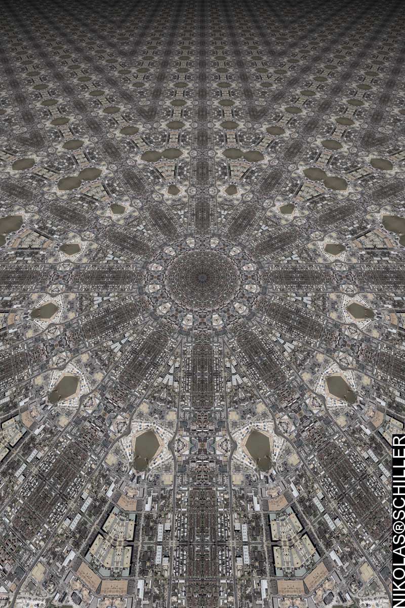
A New & Arabesque Map of the Hirshhorn Museum and Sculpture Garden

This antique map mashup is over 400 years in the making. It features the Library of Congress‘ copy of Willem Janszoon Blaeu’s Nova totius terrarum orbis geographica ac hydrographica tabula, which was published in Amsterdam in 1606. I removed the original Mercator-inspired map from the center and kept the highly decorative border similar to my other antique map mashups. The border contains allegorical drawings of the seven known planets, the four elements, the four seasons, and the seven wonders of the ancient world (copied from Dutch painter Maarten van Heemskerck [1498-1574]). This border was used on hundreds of subsequent maps for the next 50+ years by Blaeu and his son on a variety of maps. Interestingly, Washington, DC has a few modern replicas of the seven ancient wonders, but I’ll let you figure out which ones they are! (Anyone want to guess which two I can see from my rooftop?!?) The name of the map is a play on words based on the 18th century naming convention “A New and Accurate Map..” The central portion of the map features modified aerial photography (an arabesque) from the USGS (taken in the spring of 2005) of the circularly-shaped Hirshhorn Museum and Sculpture Garden on the National Mall in Washington, DC.


Israel / Palestine 1993

This map is derived from a scanned map of Israel & Palestine from the “Atlas of the Middle East,” which was published in January 1993 by the U.S. Central Intelligence Agency and obtained from the Perry-Castañeda Library Map Collection at the University of Texas at Austin. At the time of it’s creation I was working at Georgetown University’s Center for Contemporary Arab studies and my coworker’s vacation to Lebanon had to be cancelled due to an Israeli military incursion. I chose the map because of the way the occupied Palestinian territories were shaded on the map. The CIA chose to use rather ugly black diagonal lines to say “status still undetermined” and when I modified the map something interesting happened. The stripes became the points on a hexagram or Star of David, a recognized symbol of the Jewish state of Israel. To further express my feelings toward the continued occupation & military incursion, I added the iconic image of Palestinian defiance, a cartoon character by Naji Al-Ali named Handala to the lower corner of the map. Until his assassination in 1987, Ali used this character throughout his body of work as means to convey his displeasure toward the way the issue has been handled. The aim of this map is spark dialog so that peace may prevail.


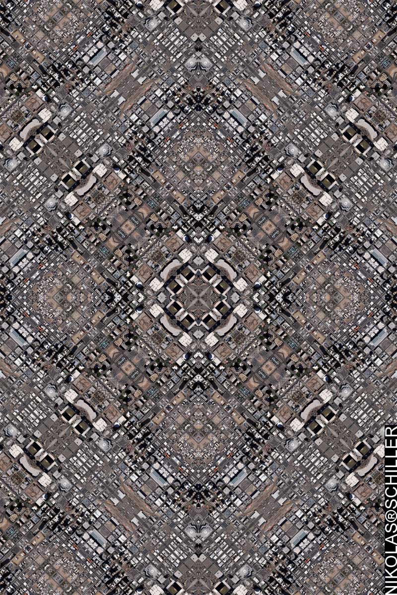
Superdome Quilt – 1st Derivative #2

The day after Hurricane Katrina devastated New Orleans, the National Oceanic & Atmospheric Administration (NOAA) sent airplanes equipped with cameras to the gulf region to assess the damage. A few days later they released these high-resolution aerial photographs of New Orleans to the public and I downloaded the two tracts that contained the flooded area around the severely damaged Superdome. Shortly thereafter I made a couple maps based on this imagery and then tried out my new procedure of recursive sampling (a quasi-fractal) to make a highly detailed tessellation of the area. As you can see in the map, the blue hues are due to flooding of the streets and the little yellow blips around the map are what is left of the roof of the Superdome. A genuine question can be asked, if I were to obtain the imagery of the Superdome today, what would it look like? This map captured a moment in time that affected the lives of millions and I can only wonder what will happen when the next category 5 hurricane hits the next urban area. Sadly, the question is not if, but when….


I am located on the 8th floor of Artomatic 2009. Hope to see you!


Fashion District Quilt #2
|| 4/17/2009 || 7:06 pm || Comments Off on Fashion District Quilt #2 || ||

: rendered at 18,000 X 12,000 :
Fashion District Quilt 2 by Nikolas R. Schiller

Using this portion of Fashion District Quilt, I composed this derivative map. I chose this layout because I liked the way the tessellation created almost-circular building clusters.


View the Google Map of the Fashion District in Los Angeles, California

: detail :

View the rest of the map details:

+ MORE


Fashion District Quilt
|| 4/16/2009 || 6:25 pm || Comments Off on Fashion District Quilt || ||

: rendered at 18,000 X 12,000 :
Fashion District Quilt by Nikolas R. Schiller

As I was doing research for the upcoming exhibition in Los Angeles, I decided to map out the area around the Gallery 727. After consulting a few different maps, I found that the gallery is technically located in the area known as the Fashion District, albeit on the periphery. Google Maps lists the area as the Historic Core, but I don’t think “Historic Core Quilt” has a good ring to it. I chose the Octagon Quilt Projection because I like the way the shadows in the streets form a compass rose around the center of the map.


View the Google Map of the Fashion District in Los Angeles, California

: detail :

View the rest of the map details:

+ MORE


Phoenix Quilt #2
|| 4/11/2009 || 6:24 pm || Comments Off on Phoenix Quilt #2 || ||

: rendered at 18,000 X 12,000 :
Phoenix Quilt 2 by Nikolas R. Schiller

Using this portion of Phoenix Quilt, I created this derivative map of downtown Phoenix, Arizona. For this map I decided to employ the Dodecagon Quilt Projection because its been a little while since I’ve used that projection. I also liked the way the rooftop of the Sandra Day O’Connor US District Court creates a nice design around the center.


View the Google Map of downtown Phoenix, Arizona

: detail :

View the rest of the map details:

+ MORE


Phoenix Quilt
|| 4/9/2009 || 12:31 pm || Comments Off on Phoenix Quilt || ||

: rendered at 18,000 X 12,000 :
Phoenix Quilt by Nikolas R. Schiller

Over the years I’ve done my best to map every major city throughout the United States. Some cities & states withhold their imagery from the public domain and I’ve been unable to map those geographies (I’m looking you at Vermont!). While Tuscon, Arizona was released to the public a few years back, Phoenix, the primary city of Arizona, was not released until sometime last year. I don’t get updates of when new imagery is released in the public domain, which has kept me in the dark about when other cities are releasing new imagery, otherwise I would have mapped Phoenix sooner.

For this map I decided to employ the Diamond Quilt Projection on the area around downtown Phoenix. The source aerial photography was originally .8 feet per pixel, but in order to capture more of the downtown area I reduced the spatial resolution of the source imagery to cover more area. In doing so, I have most of the important buildings in downtown Phoenix. Known as Cooper Square, the buildings in this map include Chase Field, U.S. Airways Center, Sandra Day O’Connor US District Court, Bank of America Tower, City Hall, Maricopa County government buildings, Phoenix Civic Center, and Patriot Square Park. Unlike most of my state capital maps, the Phoenix state capitol is located to the west and I will probably have to go back and make a subsequent map so I can include it in my ongoing series of state capitol buildings.

Anyways, I resampled a portion of this map and will post it tomorrow.


View the Google Map of downtown Phoenix, Arizona

: detail :

View the rest of the map details:

+ MORE


A Gigapan of the 105 & 110 Quilt
|| 3/23/2009 || 3:10 pm || Comments Off on A Gigapan of the 105 & 110 Quilt || ||


After uploading yesterday’s map to Gigapan, I realized that most of my maps on the website are not really panoramas. They were big files, but not wide panoramas, so I decided to make a special map that looks more like a panorama. To do this, I found the map 105 & 110 Quilt in my archives and opened it up. Then I increased the size of the canvas by a factor of 3 to 27,000 pixels wide and added two more copies of the map in the new space. Finally I saved it and uploaded it. I could easily do this with the rest of the Los Angeles Interchanges Series, but I think one example is enough for the time being. I would have made it larger, but my computer can only handle files 30,000 pixels or smaller. Maybe if I were to use a different computer with more ram and more hard drive space I could actually make a GIGApan.


If you are subscribed to my RSS feed and are reading this on through your RSS reader, please click here to view it on my website or click here to view it on the Gigapan website.


Related Interactive Entries:

+ MORE


A Gigapan of Erie Coke Corporation Eye
|| 3/22/2009 || 4:43 pm || Comments Off on A Gigapan of Erie Coke Corporation Eye || ||


After posting the map, I decided to upload it to the Gigapan website in order to add a little more interactivity to the map.


If you are subscribed to my RSS feed and are reading this on through your RSS reader, please click here to view it on my website or click here to view it on the Gigapan website.


Related Interactive Entries:

+ MORE


Erie Coke Corporation Eye
|| || 3:37 pm || Comments Off on Erie Coke Corporation Eye || ||

: rendered at 9,000 X 6,000 :
Erie Coke Corporation Eye by Nikolas R. Schiller

After I rendered Erie Coke Corporation Quilt, I sampled a portion of the map to create a derivative tessellation. I applied this tessellation to the miscellaneous projection template I created last year when I mapped downtown Kansas City, Missouri. While the previous version looked more like a human eye made of the highway, this rendition is about focusing in on the pollution coming from the smokestack at the Erie Coke Corporation. I tend to work in perfect symmetries and by centering the plant, this map becomes asymmetrical and somewhat out of balance. I achieved this by moving the center of kaleidescope to the right side, and after a few minor tweaks, I was able to magnify the smokestack without degrading the source aerial photography (see below). Or check out the interactive Gigapan.


View the Google Map of the Erie Coke Corporation outside of Erie, Pennsylvania

: detail :

View the rest of the map details:

+ MORE


A Gigapan of West Sahara Lake Circles Quilt #2
|| 3/10/2009 || 11:25 pm || Comments Off on A Gigapan of West Sahara Lake Circles Quilt #2 || ||


Last month I decided to upload my map of the New York Public Library to Gigapan to see what it looked like. Today I uploaded my most recent map for you to check out. I’m not sure if I’ll continue to upload my maps here because it takes a long time to open them up and resave them as jpegs, but I find them quite fun to look at. Maybe the next one I’ll have something hidden in the map and make it into a quasi-Where’s Waldo style game.


If you are subscribed to my RSS feed and are reading this on through your RSS reader, please click here to view it on my website or click here to view it on the Gigapan website.


Related Interactive Entries:

+ MORE


The Daily Render By
A Digital Scrapbook for the Past, Present, and Future.

©2004-2026 Nikolas R. Schiller - Former Colonist of the District of Columbia - Privacy Policy - Fair Use - RSS - Contact


::LAST 51 POSTS::

Fair Use


48 queries. 2.894 seconds.
Powered by WordPress

Photo by Charlie McCormick
Hello! Thanks for stopping by! My name is Nikolas Schiller. I am an American citizen currently living in New York City and working remotely to support structural change in Washington, DC.

This blog is my online repository of what I have created or found online since May of 2004. I've been on hiatus since 2018 but plan on contributing more content in the not so distant future.

If you have any questions or comments, please contact:

If you would like to use content found here, please consult my Fair Use page.

::THE QUILT PROJECTION::

Square
Square

Diamond
diamond

Hexagon
hexagon

Octagon
octagon

Dodecagon
Dodecagon

Beyond
beyond

::OTHER PROJECTIONS::

The Lenz Project
Lenz

Mandala Project
Mandala

The Star Series


Abstract Series
abstract

Memory Series
Memory

Mother Earth Series
Mother Earth

Misc Renderings
Misc

::POPULAR MAPS::

- The Los Angeles Interchanges Series
- The Lost Series
- Terra Fermi
- Antique Map Mashups
- Google StreetView I.E.D.
- LOLmaps
- The Inaugural Map
- The Shanghai Map
- Ball of Destruction
- The Lenz Project - Maps at the Library of Congress
- Winner of the Everywhere Man Award

::MONTHLY ARCHIVES::


@NikolasSchiller

::LOCATIONS & CATEGORIES::

  • 2004 Elections (2)
  • 2008 Elections (35)
  • 2014 Elections (4)
  • 2016 Elections (2)
  • ACLU (3)
  • Activism (287)
  • Adbusters (13)
  • Advertisements (33)
  • aerial photography (19)
  • Analysis (31)
  • Animals (30)
  • animated gif (7)
  • Animation (25)
  • Antique (104)
  • Apple (1)
  • Arabic (17)
  • Architectural Archeology (9)
  • Artomatic (25)
  • Astronomy (15)
  • Astrophotography (9)
  • Audio (2)
  • Awards (3)
  • Backpacking (2)
  • banner graphics (5)
  • Beat Google to the Map (56)
  • bicycle (23)
  • Birds-Eye View (5)
  • Blaeu (10)
  • Book Covers (7)
  • Bridge (10)
  • Building (15)
  • calendar (28)
  • calligraphy (6)
  • Capital (61)
  • Cars (18)
  • Cartography (74)
  • Cartoon (9)
  • Celestial (31)
  • Censorship (32)
  • Chinese (7)
  • Chronicling America (34)
  • Classroom (5)
  • Clothing (12)
  • Commentary (76)
  • Commissioned (27)
  • Credit Cards (3)
  • Crime (12)
  • Cyrillic Alphabet (1)
  • DAILY LINKS (30)
  • Dance (2)
  • DC History (93)
  • Design (102)
  • Digital Scrap (5)
  • Election (11)
  • ESA (3)
  • Facebook (19)
  • Fantasy (3)
  • Fashion (23)
  • Fast Food (2)
  • FBI (7)
  • Flag (15)
  • flickr (4)
  • Found Map (56)
  • French (9)
  • Gallery (54)
  • Gardening (25)
  • General (256)
  • George Bush (12)
  • GIS (69)
  • GMO Labeling (4)
  • Google (31)
  • Google AdSense (4)
  • Google AdWords (3)
  • Google Earth (28)
  • Google Maps (47)
  • Google Reader (4)
  • Google Streetview (8)
  • GPS (7)
  • Graffiti (5)
  • Greek (4)
  • Green (72)
  • Green Party (18)
  • Healthcare (15)
  • Highway (35)
  • Hiking (2)
  • Hipster (2)
  • history (151)
  • Holidays (10)
  • House Party (2)
  • Hubble Telescope (2)
  • Humor (88)
  • In The News (88)
  • Insects (2)
  • Interactive (74)
  • Interiors (4)
  • IP Trace (28)
  • Latin (22)
  • Law (15)
  • Lecture (11)
  • Legislation (19)
  • Library (21)
  • Library of Congress (66)
  • Location (1,018)
  • LOLMaps (3)
  • Mass Transit (6)
  • Memorandum (2)
  • meta-data (32)
  • Mobile Phone Applications (1)
  • Movie (3)
  • MrSID (4)
  • MSN (5)
  • Museum (5)
  • Music (48)
  • MySpace (6)
  • NASA (10)
  • National Archives (3)
  • News (182)
  • Obituary (2)
  • Oil (4)
  • Ornithology (4)
  • orthophotography (4)
  • OSCE (16)
  • Photography (134)
  • Poetry (18)
  • Portuguese (1)
  • postmodern (8)
  • QR code (9)
  • QTVR (4)
  • Radio (3)
  • Renderings (675)
  • RSS (3)
  • Seasons (12)
  • Sold (40)
  • Spanish (7)
  • Speech (5)
  • Sports (1)
  • Stadium (40)
  • statehood (94)
  • Statistics (2)
  • Stellarium (4)
  • Stereogram (1)
  • Street (21)
  • Street Art (10)
  • Submissions (5)
  • Tattoo (2)
  • Testimony (2)
  • time-lapse (19)
  • Torture (3)
  • Transportation (6)
  • TV (23)
  • Twitter (5)
  • University (41)
  • Update (24)
  • Vegetarianism (2)
  • Video (49)
  • Vimeo (18)
  • visualization (36)
  • Washington Critic (2)
  • Weather (19)
  • Web Crawler (9)
  • Wikipedia (14)
  • Wordpress (4)
  • Wordpress Upgrade (2)
  • World Wind (3)
  • Yahoo (6)
  • YouTube (113)
  • Zodiac (23)


  • thank you,
    come again!