The Daily Render

by

A Digital Scrapbook for the Past, Present, and Future

| FRONT PAGE | GEOSPATIAL ART | DC HISTORY / TIMELINE | NEWS | COLONIST | FOUND MAPS | FRACTALS |
| PHOTOGRAPHY | ANTIQUE | DESIGN | VIDEO | | CONTACT |

Map of Teacher Starting Salary vs. Annual Amount Spent on Inmates
|| 9/23/2009 || 11:50 pm || + Render A Comment || ||

Map of Teacher Starting Salary vs. Annual Amount Spent on Inmates

I found this map through a friend’s link on Facebook. It shows how each state pays it’s new teachers compared to the amount that each state spends on each inmate. I was quite surprised to see the variance in starting pay throughout the United States.

In summary:

  • Alabama is the only state to pay their new teachers $20,000 more than what is spent on each inmate
  • 23 states pay their new teachers $10,000 – $19,999 more than what is spent on each inmate
  • 6 states pay their new teachers $5,000 – $9,999 more than what is spent on each inmate
  • 8 states pay their new teachers $2,000-$2,999 more than what is spent on each inmate
  • 6 states pay their new teachers about the same that is spent on each inmate (+/- $1,999)
  • Massachusetts & Oregon spend $2,000-$2,999 more on each inmate than each new teacher
  • Wisconsin spends $3,000-$3,999 more on each inmate than each new teacher
  • Rhode Island spends $4,000-$4,999 more on each inmate than each new teacher
  • Maine & Minnesota spend $5,000 more on each inmate than each new teacher

Fortunately, more states (38) pay their new teachers more than inmates. But the larger issues comes to my mind. Do these inmates even belong in jail? Are they being incarcerated due to a non-violent crime? Conversely, do violent criminals need more attention and therefore more money needs to be spent on them? Should we, as a society, be paying our new teachers more money in order to prevent people from not receiving a complete education, resorting to crime, and ending up in jail? I will not attempt to answer these questions, but I will say that America has more people incarcerated than any other country in the world and I hope this changes.


*The District of Columbia is excluded from this map


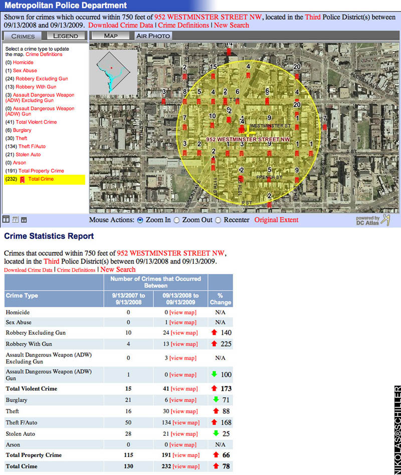
Violent Crime In My Neighborhood Has Increased Over 100% in the Last Year
|| 9/22/2009 || 1:43 pm || 1 Comment Rendered || ||

Last week my City Councilmember, Jim Graham, sent an e-mail about the drop in crime over the last 30 days to my neighborhood association listserv and included various local government officials like the DC Police Chief, Cathy Lanier. The e-mail featured two graphs of data from DC’s Crime Map that covered the police service area of my neighborhood and showed the crime statistics of August to September of 2008 compared to August to September of 2009. What the graph lacked, however, was the hyperlocal angle of the crime taking place in the immediate vicinity of the block that we live on and the larger picture showing the other 11 months of crime data.

As a two-time victim of violent crime last year in my neighborhood, on my front doorstep & at the end of the block, I was fully aware that the data in the graphs included me, so I felt compelled to use the very same tool my councilmember used to analyze the extent of the crimes that have recently taken place. The result genuinely stunned me and I proceeded to respond to his e-mail (text below) with the two maps (above & below) that show the various crimes that have taken place in my neighborhood.

+ MORE


5 More Random Banners Now ‘Greek’ Visitors
|| 9/19/2009 || 3:47 pm || 1 Comment Rendered || ||

Banner Graphic Featuring I-35W Bridge Quilt #2

New banner graphic featuring my name written in Greek over I-35W Bridge Quilt #2

About a month ago I had a random friend request on Facebook from a woman named Athina who lives in Greece. Opting to inflate my friend count over potential security fears, I added her without question. A couple weeks later I visited her Facebook page and noticed that she has a blog that was written completely in the Greek language. I had just posted my latest batch of banners using the Cyrillic alphabet, so I sent her an e-mail asking if she’d be interested in translating my name into Greek. She obliged and today I made 5 more banners to be randomly displayed.

Greek is one of the languages I’ve always wanted to learn. I spent some time in high school taking Latin, which I have since found to be an invaluable contribution to my continued exploration of history. But Koine Greek, the lingua franca of the Eastern Mediterranean around the time of the birth of Christ, has always fascinated me. The Septuagint, a 3rd century B.C. Greek translation of the Hebrew Bible, used this dialect of the language. And while modern Greek is considerably different in many aspects from it’s thousand+ year-old counterpart, I would still like to learn both or at least start getting my mind around the alphabet.

Now I would be remiss if I didn’t return the cultural exchange for my friend Athina who did the translation for me. She owns a yacht charter company called Stamatis Yachting, which offers a wide variety of yachts that can take you & your friends around the various Greek islands. They also have skippers that can be contracted so you don’t have to know how to sail in order to experience the joys of sailing on the Mediterranean. If you are planning on a trip to Greece in the near future, please do not hesitate to contact her about chartering one of their yachts.

Below are the rest of the new banner graphics hyperlinked to their original blog entries:

+ MORE


Bright Felon: Autobiography And Cities By Kazim Ali Is Now Available
|| 9/1/2009 || 6:52 pm || 1 Comment Rendered || ||


This groundbreaking, trans-genre work—part detective story, part literary memoir, part imagined past—is intensely autobiographical and confessional. Proceeding sentence by sentence, city by city, and backwards in time, poet and essayist Kazim Ali details the struggle of coming of age between cultures, overcoming personal and family strictures to talk about private affairs and secrets long held. The text is comprised of sentences that alternate in time, ranging from discursive essay to memoir to prose poetry. Art, history, politics, geography, love, sexuality, writing, and religion, and the role silence plays in each, are its interwoven themes. Bright Felon is literally “autobiography” because the text itself becomes a form of writing the life, revealing secrets, and then, amid the shards and fragments of experience, dealing with the aftermath of such revelations. Bright Felon offers a new and active form of autobiography alongside such texts as Theresa Hak Kyung Cha’s Dictee, Lyn Hejinian’s My Life, and Etel Adnan’s In the Heart of the Heart of Another Country.


From the Book:

You wouldn’t think I would have wanted a beacon. Rather to find myself in the wilderness on my own.

But I did, I always did.

Could there have been someone else like me, not one thing not another, barely able to choose.

A poet, a Muslim, and of a particular persuasion.

When I knew someone like me I barely knew him and we couldn’t bring ourselves to speak of the one thing we needed to speak to each other about.

Silence stretched between us taut as sin.

In 2004 I moved with Marco down the river to Beacon, NY.

Named for the signal fires placed on top of each mountain in chain running from New York City to Albany.

So if either city fell to the British the insurgents at the other end would know about it.

I placed signal fires up and down each street, so anxious I was to belong somewhere.

—From the chapter “Beacon”


Endorsements:

Bright Felon will steal your heart and outrage your poetics. Part memoir, part trip book, part literary discourse, there is in it an urgent sense of a life lived in words. The tale is one of both innocence and experience. Rigorous, romantic, experimental, true, and yet mysterious, it is a book for the ages.” —Laura Moriarty, author of A Semblance: Selected and New Poems, 1975–2007

“Kazim Ali writes in Bright Felon a prose shaped by the various cities he has lived and loved in. This is a book that is so much more than memoir or autobiography. It is embodied and questioning and it carries through its politics a grace and generosity. —Juliana Spahr, author of Fuck You, Aloha, I Love You


KAZIM ALI is the author of two books of poetry, The Far Mosque (2004) and The Fortieth Day (2008). He is an assistant professor of creative writing at Oberlin College and teaches in the low-residency MFA program of the University of Southern Maine. He is one of the founding editors of Nightboat Books.


The text above was copied from the website of book distributor, University Press of New England


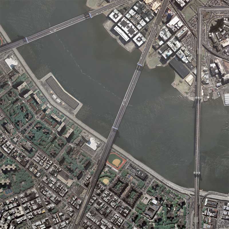
Below is a detail from my map Manhattan & Brooklyn Bridge Quilt, which is featured on the cover of the book:

Detail of Manhattan and Brooklyn Bridge Quilt


Related New York City Entries:

+ MORE


The Pentagon Timelapse Animated GIF (2001-2005)
|| || 5:00 pm || + Render A Comment || ||

Still frame from The Pentagon Timelapse Animated GIF featuring USGS aerial photography from 2005Still frame from The Pentagon Timelapse Animated GIF featuring USGS aerial photography from 2005
Click the image above to watch the animation

Last night I was going through one of my external hard drives and rediscovered a cache of “old” satellite imagery. I rarely publish any entries that use satellite imagery due to copyright issues because, generally speaking, the company that owns the satellite also owns all the pixels and this prevents me from legally creating derivative works. Today, however, I decided to test the boundaries with this legacy satellite imagery of the Pentagon and feel that this creation is protected under the fair use doctrine of US copyright law. You can always contact GeoEye if you are interested in purchasing satellite imagery from the IKONOS satellite.

The Animated GIF below features 9 frames consisting of 7 satellite images from the IKONOS Satellite (2001-2002) and two public domain aerial photographs from the USGS (2002 & 2005). It begins with satellite imagery taken four days before 9/11/01 and ends with a USGS aerial photograph taken in September 2005. The frames in between show the aftermath and the subsequent rebuilding of the Pentagon. I did my best to line up the building in my image editing program, but it’s not 100% perfect due to the angle in which some of the imagery was taken.


I have chosen to place the The Pentagon Timelapse Animated GIF “below the fold” so that visitors to the front page of this website are not downloading the somewhat large file. Please be patient while it downloads……

+ MORE


40 Random Banners Now Greet You
|| 8/31/2009 || 10:27 pm || 2 Comments Rendered || ||

A banner graphic featuring my name written using the Cyrillic alphabet over my map New York Public Library Quilt

New banner graphic featuring my name written using the Cyrillic alphabet over my map New York Public Library Quilt

The last time I added new banner graphics to this website was back in July of 2007 and since I’ve been updating the layout of this website lately, I decided to add some new banners into the mix. Earlier today a friend of mine who specializes in the Russian language responded to an e-mail I sent her about Google’s translation of my name. Her response indicated that the translation was infact an incorrect spelling and she offered a substitute spelling. I was then able to cut & paste the text and make six new banners that feature my name using the Cyrillic alphabet over the top of previously made maps on this website. In conjunction with the first batch of banner graphics that I made, there are now 40 different banner graphics that are randomly displayed each time a page on this blog is loaded.

Below are the rest of the new banner graphics hyperlinked to their original blog entries:

+ MORE


“NO” – Found Cartographic Typography
|| 8/28/2009 || 4:44 pm || 1 Comment Rendered || ||

Photograph of two framed maps spelling out the word NO in my hallway

I have a quite a few framed maps hanging in my house just waiting to be purchased. In fact, I have more framed maps than I have available wall space. Usually before we have a big party I go around the house and rearrange the framed maps so our guests see different maps each time they visit. The other night when I was walking up the stairs I noticed that the two maps that I’ve had up for a months actually spelled something. The N from N Prague and the torus around Georgetown Lenz #2 kind of spell out the word NO. I wonder if guests saw this? Or if it could have been construed as a subliminal message?

Below are the maps as they appeared in their original blog entries:

+ MORE


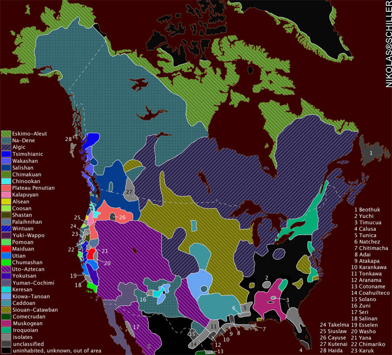
Map of the Indigenous Languages of North America
|| 8/25/2009 || 5:01 pm || + Render A Comment || ||

Map Created by Wikipedia User ish ishwar in 2005, using the GIMP software.
Click to view original map.

I came across this map of the Indigenous Languages of North America the other night and it reminded me of my previous entry related to the map of the languages of Europe.

According to the Wikipedia entry on the map:

about sources

Map redrawn and modified primary based on two maps by cartographer Roberta Bloom appearing in Mithun (1999:xviii-xxi). Incidentally, these maps are very derivative of the Driver map of the 1950s-60s (which means that, although published in 1999, it is not as up-to-date as one might think). The other main source used is the up-to-date and very well-done map found in Goddard (1996), which was revised as Goddard (1999). Essentially, Bloom’s map was used for the projection and general outline of language borders while Goddard’s maps were used to adjust Bloom’s borders to reflect the more recent research.
Additional references include Sturtevant (1978-present), Mithun (1999:606-616), and Campbell (1997:353-376). Mithun and Campbell have several maps based on the maps found in Sturtevant (1978-present) and Bright (1992).


about map content

— Map delineates each language family in a unique color.
Language isolates are all in dark grey, e.g. Chitimacha (#7) is an isolate in Louisiana. This is not meant to imply any relationship among them whatsoever. All isolates are assigned a number and listed on the right side of map.
Unclassified languages (i.e. #1 Beothuk, #4 Calusa, #8 Adai, #10 Karankawa, #12 Aranama, #15 Solano, #19 Esselen, #26 Cayuse) are in light grey and are also assigned a number and listed with the isolates on the right. (Unclassified languages in the case of North America are unclassified because there is not sufficient data to determine genealogical relationship.)
— Areas in white are either
1. uninhabited (in Alaska, Canada, Greenland),
2. unknown (due to early extinction and little or no data; this is mostly in the East), or
3. outside of subject area (in Mexico). (note that Seri (#17) is included because it is usually considered part of the Southwest culture area and also included in various Hokan phylum proposals.)
— This is a historical map: Although most languages are still spoken in North America, the extent of their distribution has been profoundly affected by European contact — many languages have become extinct (sometimes including even the peoples).
— Language areas are those at earliest time of European contact, as far as can be determined. Since contact occurred at different times in different areas, no historical Native American maps of the entire continent are of a single time period.
Language areas are not as well-defined as this map would suggest: borders are often fuzzy and arbitrary and the entire language area may not be fully occupied by language speakers.
— Na-Dene here is Athabaskan-Eyak-Tlingit, excluding Haida (#28).
— The following groupings are disputed by some (or are considered not fully demonstrated):
1. Plateau Penutian (aka Shahapwailutan) = Klamath-Modoc (isolate) + Molala (isolate) + Sahaptian (family). Sometimes Cayuse (#26) is included in Plateau Penutian, but this language is not very well documented and is now extinct. Thus, it is considered unclassified here.
2. Yuki-Wappo = Yuki (isolate) + Wappo (isolate).


Note: Since I inverted the color scheme when publishing this map, the white is black and the grey is still grey.

What struck me about this map was how many languages were spoken in North America before European colonization. I’m curious about how similar and dissimilar some of the languages were to each other, but alas, I can never hear all of them now. When it comes to the spatial proximity of the language isolates with languages of larger tribes, I’m curious as to how these languages were able to remain linguistically different. While some tribes travelled each year between summer and winter cities, I would imagine that there was some interaction- either through peaceful trade or warfare. Sadly, most of that information has been lost, but I’m glad some researchers have taken the time to attempt to draw the map above.


Related Found Maps:

+ MORE


[Commissioned Map] National Gallery of Art Sculpture Garden Quilt – Tessellation #4 / Drafts #7 & #8
|| 8/22/2009 || 7:12 pm || + Render A Comment || ||

:: Rendered at 900 x 600 ::
Sculpture Garden Quilt - Tessellation 4 featuring the Hexagon Quilt Projection by Nikolas Schiller

A few days ago I started on a new commissioned map of the Sculpture Garden at the National Gallery of Art on the National Mall in Washington, DC. The client made it somewhat easier for me because they were interested in either a Hexagon Quilt Projection map (above) or an Octagon Quilt Projection map (below). Unlike the previous two drafts, today’s drafts feature a far-away view of the area immediately around the Sculpture Garden.

View the Google Map of the Sculpture Garden at the National Gallery of Art


Please contact me if you would like to have a custom map designed for your home, office, or as a gift for someone special!


:: Rendered at 900 x 600 ::
Sculpture Garden Quilt - Tessellation 4 featuring the Octagon Quilt Projection by Nikolas Schiller


[Commissioned Map] National Gallery of Art Sculpture Garden Quilt – Tessellation #3 / Drafts #5 & #6
|| 8/19/2009 || 6:42 pm || 1 Comment Rendered || ||

:: Rendered at 900 x 600 ::
Sculpture Garden Quilt - Tessellation 3 featuring the Hexagon Quilt Projection by Nikolas Schiller

The other day I started on a new commissioned map of the Sculpture Garden at the National Gallery of Art on the National Mall in Washington, DC. The client made it somewhat easier for me because they were interested in either a Hexagon Quilt Projection map (above) or an Octagon Quilt Projection map (below). Like the previous two drafts, today’s drafts feature a close-up view of the area around the Sculpture Garden.

View the Google Map of the Sculpture Garden at the National Gallery of Art


Please contact me if you would like to have a custom map designed for your home, office, or as a gift for someone special!


:: Rendered at 900 x 600 ::
Sculpture Garden Quilt - Tessellation 3 featuring the Octagon Quilt Projection by Nikolas Schiller


The Daily Render By
A Digital Scrapbook for the Past, Present, and Future.

©2004-2023 Nikolas R. Schiller - Colonist of the District of Columbia - Privacy Policy - Fair Use - RSS - Contact


::LAST 51 POSTS::

Fair Use


52 queries. 0.784 seconds.
Powered by WordPress

Photo by Charlie McCormick
Nikolas Schiller is a second-class American citizen living in America's last colony, Washington, DC. This blog is my on-line repository of what I have created or found on-line since May of 2004. If you have any questions or comments, please contact:

If you would like to use content found here, please consult my Fair Use page.

::THE QUILT PROJECTION::

Square
Square

Diamond
diamond

Hexagon
hexagon

Octagon
octagon

Dodecagon
Dodecagon

Beyond
beyond

::OTHER PROJECTIONS::

The Lenz Project
Lenz

Mandala Project
Mandala

The Star Series


Abstract Series
abstract

Memory Series
Memory

Mother Earth Series
Mother Earth

Misc Renderings
Misc

::POPULAR MAPS::

- The Los Angeles Interchanges Series
- The Lost Series
- Terra Fermi
- Antique Map Mashups
- Google StreetView I.E.D.
- LOLmaps
- The Inaugural Map
- The Shanghai Map
- Ball of Destruction
- The Lenz Project - Maps at the Library of Congress
- Winner of the Everywhere Man Award

::MONTHLY ARCHIVES::


::LOCATIONS & CATEGORIES::

  • 2004 Elections (2)
  • 2008 Elections (35)
  • 2014 Elections (4)
  • 2016 Elections (2)
  • ACLU (3)
  • Activism (287)
  • Adbusters (13)
  • Advertisements (33)
  • aerial photography (19)
  • Analysis (31)
  • Animals (30)
  • animated gif (7)
  • Animation (25)
  • Antique (104)
  • Apple (1)
  • Arabic (17)
  • Architectural Archeology (9)
  • Artomatic (25)
  • Astronomy (15)
  • Astrophotography (9)
  • Audio (2)
  • Awards (3)
  • Backpacking (2)
  • banner graphics (5)
  • Beat Google to the Map (56)
  • bicycle (23)
  • Birds-Eye View (5)
  • Blaeu (10)
  • Book Covers (7)
  • Bridge (10)
  • Building (15)
  • calendar (28)
  • calligraphy (6)
  • Capital (61)
  • Cars (18)
  • Cartography (74)
  • Cartoon (9)
  • Celestial (31)
  • Censorship (32)
  • Chinese (7)
  • Chronicling America (34)
  • Classroom (5)
  • Clothing (12)
  • Commentary (76)
  • Commissioned (27)
  • Credit Cards (3)
  • Crime (12)
  • Cyrillic Alphabet (1)
  • DAILY LINKS (30)
  • Dance (2)
  • DC History (93)
  • Design (102)
  • Digital Scrap (5)
  • Election (11)
  • ESA (3)
  • Facebook (19)
  • Fantasy (3)
  • Fashion (23)
  • Fast Food (2)
  • FBI (7)
  • Flag (15)
  • flickr (4)
  • Found Map (56)
  • French (9)
  • Gallery (54)
  • Gardening (25)
  • General (256)
  • George Bush (12)
  • GIS (69)
  • GMO Labeling (4)
  • Google (31)
  • Google AdSense (4)
  • Google AdWords (3)
  • Google Earth (28)
  • Google Maps (47)
  • Google Reader (4)
  • Google Streetview (8)
  • GPS (7)
  • Graffiti (5)
  • Greek (4)
  • Green (72)
  • Green Party (18)
  • Healthcare (15)
  • Highway (35)
  • Hiking (2)
  • Hipster (2)
  • history (151)
  • Holidays (10)
  • House Party (2)
  • Hubble Telescope (2)
  • Humor (88)
  • In The News (88)
  • Insects (2)
  • Interactive (74)
  • Interiors (4)
  • IP Trace (28)
  • Latin (22)
  • Law (15)
  • Lecture (11)
  • Legislation (19)
  • Library (21)
  • Library of Congress (66)
  • Location (1,018)
  • LOLMaps (3)
  • Mass Transit (6)
  • Memorandum (2)
  • meta-data (32)
  • Mobile Phone Applications (1)
  • Movie (3)
  • MrSID (4)
  • MSN (5)
  • Museum (5)
  • Music (48)
  • MySpace (6)
  • NASA (10)
  • National Archives (3)
  • News (182)
  • Obituary (2)
  • Oil (4)
  • Ornithology (4)
  • orthophotography (4)
  • OSCE (16)
  • Photography (134)
  • Poetry (18)
  • Portuguese (1)
  • postmodern (8)
  • QR code (9)
  • QTVR (4)
  • Radio (3)
  • Renderings (675)
  • RSS (3)
  • Seasons (12)
  • Sold (40)
  • Spanish (7)
  • Speech (5)
  • Sports (1)
  • Stadium (40)
  • statehood (94)
  • Statistics (2)
  • Stellarium (4)
  • Stereogram (1)
  • Street (21)
  • Street Art (10)
  • Submissions (5)
  • Tattoo (2)
  • Testimony (2)
  • time-lapse (19)
  • Torture (3)
  • Transportation (6)
  • TV (23)
  • Twitter (5)
  • University (41)
  • Update (24)
  • Vegetarianism (2)
  • Video (49)
  • Vimeo (18)
  • visualization (36)
  • Washington Critic (2)
  • Weather (19)
  • Web Crawler (9)
  • Wikipedia (14)
  • Wordpress (4)
  • Wordpress Upgrade (2)
  • World Wind (3)
  • Yahoo (6)
  • YouTube (113)
  • Zodiac (23)


  • thank you,
    come again!