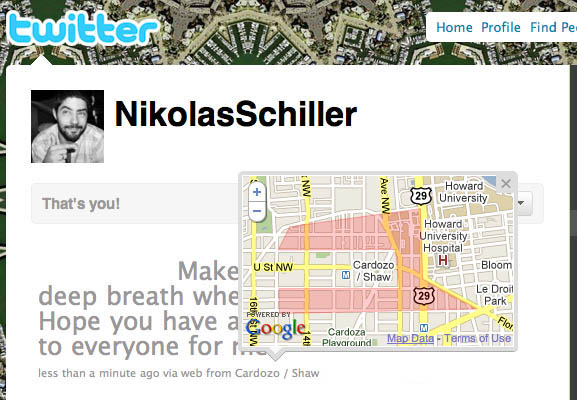
The other day I allowed Twitter to track my location. Much to my chagrin, the map that was created looks awful. At first I thought it looked like PacMan and now I’ve come to the conclusion that it looks like T-Rex, and that ‘T’ stands for Twitter.
| FRONT PAGE |
GEOSPATIAL ART |
DC HISTORY / TIMELINE |
NEWS |
COLONIST |
FOUND MAPS |
FRACTALS |
|
PHOTOGRAPHY |
ANTIQUE |
DESIGN |
VIDEO |
|
CONTACT |
A T-Rex Google Map On My Neighborhood Via Twitter
|| 3/15/2010 || 11:23 pm || Comments Off on A T-Rex Google Map On My Neighborhood Via Twitter || ||
No comments yet.
+ RSS feed for comments on this post.
Sorry, the comment form is closed at this time.
©2004-2026 Nikolas R. Schiller - Former Colonist of the District of Columbia - Privacy Policy - Fair Use - RSS - Contact
::LAST 51 POSTS::
55 queries. 0.459 seconds.
Powered by WordPress


::THE QUILT PROJECTION::
Square |
Diamond |
Hexagon |
Octagon |
Dodecagon |
Beyond |
::OTHER PROJECTIONS::
The Lenz Project |
Mandala Project |
The Star Series |
Abstract Series |
Memory Series
|
Mother Earth Series
|
|
Misc Renderings
 |
::POPULAR MAPS::
- The Los Angeles Interchanges Series::MONTHLY ARCHIVES::
::LOCATIONS & CATEGORIES::