The Daily Render

by

A Digital Scrapbook for the Past, Present, and Future

| FRONT PAGE | GEOSPATIAL ART | DC HISTORY / TIMELINE | NEWS | COLONIST | FOUND MAPS | FRACTALS |
| PHOTOGRAPHY | ANTIQUE | DESIGN | VIDEO | | CONTACT |

Marquette High School Quilt
|| 11/28/2005 || 1:39 pm || 2 Comments Rendered || ||

: rendered at 18,000 X 12,000 :

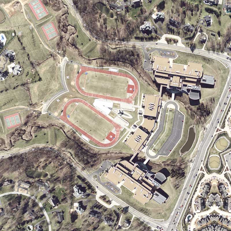
In the last two weeks I’ve reconnected with about 10 different folks I knew back in high school. To celebrate this, and to actually follow through with one of my old ideas, I made a rendering for my high school in Clarkson Valley, MissouriMarquette High School. Located about 22 miles from downtown Saint Louis, in the affluent West County, this public high school cost over 20 million dollars to construct and in less than 10 years it was expanded to hold more students. There were trailers placed in the front of the school for a few years and the year after I graduated in 1999, they finished the expansion and removed the trailers. The aerial photograph used was taken by the USGS in March of 2002, and if you look closely, the sidewalk in front of the school is still visible where the trailers used to be.

I could probably go on & on about aboutt this rendering, filling in every detail of the complex mental map I have, but I won’t. If I do another rendering, I’ll be sure to add another story or two about that place, space, and time.

For Christmas, I’d like to print up a copy of this rendering and donate it to the school….

: detail :

View the rest of the details:

+ MORE


GWU Quilt #4
|| 11/21/2005 || 11:26 pm || Comments Off on GWU Quilt #4 || ||

: rendered at 18,000 X 12,000 :

4 different maps in this series, and I must say I’m very happy with it.

View Details:

+ MORE


GWU Quilt #3
|| 11/20/2005 || 1:18 pm || Comments Off on GWU Quilt #3 || ||

: rendered at 18,000 X 12,000 :

#4 on it’s way..

View Details:

+ MORE


GWU Quilt #2
|| 11/19/2005 || 8:14 pm || Comments Off on GWU Quilt #2 || ||

: rendered at 18,000 X 12,000 :

I am adding/subtracting a new line of symmetry for each rendering… #3 on it’s way..

Vew rendering details:

+ MORE


GWU Quilt
|| 11/18/2005 || 7:07 am || Comments Off on GWU Quilt || ||

: rendered at 18,000 X 12,000 :

The lecture at GWU inspired me :-)

I used to live near the line of symmetry:
My old dorm room is wedged between the reflections of the E St. building

+ MORE


Dupont Circle Quilt
|| 11/17/2005 || 7:32 am || Comments Off on Dupont Circle Quilt || ||

: rendered at 12,000 X 8,000 :
Dupont Circle Quilt by Nikolas Schiller

I used one of the smallest tessellations yet to make this. The source imagery of the tiled Dupont Circle was only 2,600 pixels, but I made the right calculations to keep spatial resolution very similar the final product the same as the source (I counted how many times I saw the full tiled go across and multipled by 2,600). I like how it turned out, but I wish there was more merging of the circle itself, as in the circle itself would become a larger circle around the center. Up next, I am going to make one using nothing but imagery of GWU.

+ MORE


Woodson High School Quilt
|| 11/6/2005 || 12:42 pm || Comments Off on Woodson High School Quilt || ||

: rendered at 18,000 X 12,000 :

Thus begins my “8 Wards, One State” series.

Woodson High School…

+ MORE


Abstract George W. Bush
|| 10/31/2005 || 8:06 pm || 1 Comment Rendered || ||

: rendered at 10,000 X 7500 :

On Valentines Day I made this for good ‘o GW, and for Halloween I made him something a bit more abstract.

#UPDATE## 2/16/08 — added background

This was the last map I made using the 2002 USGS aerial photography of the area around the White House. By combining a United States Air Force high-resolution publicity photograph of George W. Bush, I created a unique tessellation that I overlaid on to the surface of a complex 3-D object. In the background I used the same tessellation but placed the design into in a kaleidoscopic pattern similar to the More Quilt Projection style. The result is both eerie and visually engaging. Made on Halloween, it could be taken as an abstract Halloween mask, but when viewed as a human interest map, it becomes slightly more twisted. At the center, below the obligatory American flag lapel pins, is a mirrored image of a visually redacted White House. This is the same legacy aerial photography that was used in the wildly popular Inaugural Map I published in January of 2005. This was also the first imagery of Washington, DC used by Google Maps when it was released a couple months later. It was soon updated after people complained that the White House (and the Old Executive Office Building & Treasury Department) should not be censored.

Last year when the USGS released the 2005 Washington, DC aerial photography, the entire area around the White House was completely redacted. Shortly thereafter, I created “The White House Is Off-Limits To The Public,” an interactive geovisual environment, to showcase the egregious amount of censorship that was exercised by the National Geospatial Intelligence Agency. Google still has not updated their servers with newest public domain imagery of downtown Washington, DC….

View Details:

+ MORE


Star Series – BETA
|| 10/30/2005 || 11:46 am || Comments Off on Star Series – BETA || ||

Beta release of the Star Series Image Overlay KML file for Google Earth.
Click here to download the zipped up KML file

Instructions:
Unzip the file, drag starseries.kml file to your desktop, and double click on it to lauch Google Earth

Once loaded into Google Earth, the layer will download the maps from the Star Series hosted on my website. On the Places Panel the folder titled “Star Series” will be placed. Clicking on the triangle next to the folder you can expand and collapse the contents of the folder. By clicking on the “Send Comment” link, the blog entry in which the map is referenced will load up in the Google Earth web browser allowing you to leave a comment on my blog. By adjusting the transparency of the map overlay, you can find the area on the ground which was as a guide.

The Alpha release will have icons instead of overlays to facilitate the navigation of my maps. Within each icon will be a link for the overlay of the map.

Known Issues:
Due to large size of the maps, Google Earth might slow down considerably after they are loaded.
Google Earth’s browser is based off of Internet Explorer and my website does not show up as how I’d like it to.

Please provide me with feedback!


Taking Google Earth to a new level
|| 10/29/2005 || 10:21 am || Comments Off on Taking Google Earth to a new level || ||

Today I’ve begun geocoding my maps in Google Earth. Using the Image Overlay tool, I’ve diligently tried to match my renderings with the aerial/satellite image displayed in Google Earth. In most cases I am using the same imagery that Google Earth is and in other cases, like DC, I am placing my maps (derived from older USGS imagery) over the newer imagery. With each map I add to Google Earth, I also embed a link “Send Comment” to each respective blog entry for added interactivity. I’ve completed a few of my series and the results are awesome. You can now fly around the world and discover my maps…

I am making two KML versions for Google Earth because I have already run into a problem with using the Image Overlay feature– I’ve made too many maps! After loading all of the maps, Google Earth slows down to a crawl. The work around is to make one layer with basic icons without the image overlay and have the map load within the icon’s window with a link to it’s respective Image Overlay file. This prevents the Google Earth from loading all of the maps at once, and it allows me to maintain a comment link to my blog. What I hope to have in the end is 2 master KML files- one personal & one for the web, and then produce an Image Overlay KML file for each map for the web. The personal file used for presentations and the web will be for what was described above.

To finish off this task, I now need to go back through my blog and add the Image Overlay KLM file for each respective blog entry (to make discovery bi-directional, as in you can find the map first on my website or within Google Earth). I will add a footer, “View this Map in Google Earth,” and have the Image Overlay KML link.

First up will be the master Image Overlay file from which I can extract the individual KML files for the blog entries, and then lastly make the layer for the public. The public layer is going to take the longest, but it will be the most useful. This all sounds like a lot of work, and I do believe it is, but results will be rewarding- I will have taken Google Earth to my level (wherever that may be).


The Daily Render By
A Digital Scrapbook for the Past, Present, and Future.

©2004-2026 Nikolas R. Schiller - Former Colonist of the District of Columbia - Privacy Policy - Fair Use - RSS - Contact


::LAST 51 POSTS::

Fair Use


53 queries. 3.239 seconds.
Powered by WordPress

Photo by Charlie McCormick
Hello! Thanks for stopping by! My name is Nikolas Schiller. I am an American citizen currently living in New York City and working remotely to support structural change in Washington, DC.

This blog is my online repository of what I have created or found online since May of 2004. I've been on hiatus since 2018 but plan on contributing more content in the not so distant future.

If you have any questions or comments, please contact:

If you would like to use content found here, please consult my Fair Use page.

::THE QUILT PROJECTION::

Square
Square

Diamond
diamond

Hexagon
hexagon

Octagon
octagon

Dodecagon
Dodecagon

Beyond
beyond

::OTHER PROJECTIONS::

The Lenz Project
Lenz

Mandala Project
Mandala

The Star Series


Abstract Series
abstract

Memory Series
Memory

Mother Earth Series
Mother Earth

Misc Renderings
Misc

::POPULAR MAPS::

- The Los Angeles Interchanges Series
- The Lost Series
- Terra Fermi
- Antique Map Mashups
- Google StreetView I.E.D.
- LOLmaps
- The Inaugural Map
- The Shanghai Map
- Ball of Destruction
- The Lenz Project - Maps at the Library of Congress
- Winner of the Everywhere Man Award

::MONTHLY ARCHIVES::


@NikolasSchiller

::LOCATIONS & CATEGORIES::

  • 2004 Elections (2)
  • 2008 Elections (35)
  • 2014 Elections (4)
  • 2016 Elections (2)
  • ACLU (3)
  • Activism (287)
  • Adbusters (13)
  • Advertisements (33)
  • aerial photography (19)
  • Analysis (31)
  • Animals (30)
  • animated gif (7)
  • Animation (25)
  • Antique (104)
  • Apple (1)
  • Arabic (17)
  • Architectural Archeology (9)
  • Artomatic (25)
  • Astronomy (15)
  • Astrophotography (9)
  • Audio (2)
  • Awards (3)
  • Backpacking (2)
  • banner graphics (5)
  • Beat Google to the Map (56)
  • bicycle (23)
  • Birds-Eye View (5)
  • Blaeu (10)
  • Book Covers (7)
  • Bridge (10)
  • Building (15)
  • calendar (28)
  • calligraphy (6)
  • Capital (61)
  • Cars (18)
  • Cartography (74)
  • Cartoon (9)
  • Celestial (31)
  • Censorship (32)
  • Chinese (7)
  • Chronicling America (34)
  • Classroom (5)
  • Clothing (12)
  • Commentary (76)
  • Commissioned (27)
  • Credit Cards (3)
  • Crime (12)
  • Cyrillic Alphabet (1)
  • DAILY LINKS (30)
  • Dance (2)
  • DC History (93)
  • Design (102)
  • Digital Scrap (5)
  • Election (11)
  • ESA (3)
  • Facebook (19)
  • Fantasy (3)
  • Fashion (23)
  • Fast Food (2)
  • FBI (7)
  • Flag (15)
  • flickr (4)
  • Found Map (56)
  • French (9)
  • Gallery (54)
  • Gardening (25)
  • General (256)
  • George Bush (12)
  • GIS (69)
  • GMO Labeling (4)
  • Google (31)
  • Google AdSense (4)
  • Google AdWords (3)
  • Google Earth (28)
  • Google Maps (47)
  • Google Reader (4)
  • Google Streetview (8)
  • GPS (7)
  • Graffiti (5)
  • Greek (4)
  • Green (72)
  • Green Party (18)
  • Healthcare (15)
  • Highway (35)
  • Hiking (2)
  • Hipster (2)
  • history (151)
  • Holidays (10)
  • House Party (2)
  • Hubble Telescope (2)
  • Humor (88)
  • In The News (88)
  • Insects (2)
  • Interactive (74)
  • Interiors (4)
  • IP Trace (28)
  • Latin (22)
  • Law (15)
  • Lecture (11)
  • Legislation (19)
  • Library (21)
  • Library of Congress (66)
  • Location (1,018)
  • LOLMaps (3)
  • Mass Transit (6)
  • Memorandum (2)
  • meta-data (32)
  • Mobile Phone Applications (1)
  • Movie (3)
  • MrSID (4)
  • MSN (5)
  • Museum (5)
  • Music (48)
  • MySpace (6)
  • NASA (10)
  • National Archives (3)
  • News (182)
  • Obituary (2)
  • Oil (4)
  • Ornithology (4)
  • orthophotography (4)
  • OSCE (16)
  • Photography (134)
  • Poetry (18)
  • Portuguese (1)
  • postmodern (8)
  • QR code (9)
  • QTVR (4)
  • Radio (3)
  • Renderings (675)
  • RSS (3)
  • Seasons (12)
  • Sold (40)
  • Spanish (7)
  • Speech (5)
  • Sports (1)
  • Stadium (40)
  • statehood (94)
  • Statistics (2)
  • Stellarium (4)
  • Stereogram (1)
  • Street (21)
  • Street Art (10)
  • Submissions (5)
  • Tattoo (2)
  • Testimony (2)
  • time-lapse (19)
  • Torture (3)
  • Transportation (6)
  • TV (23)
  • Twitter (5)
  • University (41)
  • Update (24)
  • Vegetarianism (2)
  • Video (49)
  • Vimeo (18)
  • visualization (36)
  • Washington Critic (2)
  • Weather (19)
  • Web Crawler (9)
  • Wikipedia (14)
  • Wordpress (4)
  • Wordpress Upgrade (2)
  • World Wind (3)
  • Yahoo (6)
  • YouTube (113)
  • Zodiac (23)


  • thank you,
    come again!