The Daily Render

by

A Digital Scrapbook for the Past, Present, and Future

| FRONT PAGE | GEOSPATIAL ART | DC HISTORY / TIMELINE | NEWS | COLONIST | FOUND MAPS | FRACTALS |
| PHOTOGRAPHY | ANTIQUE | DESIGN | VIDEO | | CONTACT |

Union Station Quilt #3
|| 3/12/2008 || 2:44 pm || Comments Off on Union Station Quilt #3 || ||

: rendered at 18,000 X 12,000 :Union Station Quilt #3.

I find it quite interesting being able to see the difference between spatial scales when comparing the two previous Union Station maps. Since this map uses .16 meters per pixel aerial photography and the previous two maps use imagery that was .3 meters per pixel, you can quite easily see how much less I am now showing of the area around Union Station. Specifically, this map only shows the U.S. Postal Museum, Union Station, the Thurgood Marshal Federal Building, and the U.S. Securities and Exchange Commission.View the Google Map of Union Station in downtown Washington, DC.

View the rest of the details:

+ MORE


Scott Circle Quilt #2
|| 3/9/2008 || 9:10 pm || Comments Off on Scott Circle Quilt #2 || ||

: rendered at 18,000 X 12,000 :
Scott Circle Quilt #2 by Nikolas Schiller

Read more about Scott Circle in my previous entry.

View the Google Map of Scott Circle in downtown Washington, DC.

View the rest of the details:

+ MORE


Scott Circle Quilt
|| 3/8/2008 || 1:32 pm || Comments Off on Scott Circle Quilt || ||

: rendered at 18,000 X 12,000 :
Scott Circle Quilt by Nikolas Schiller

I am in the process of making hexagon quilt projection maps of all the major traffic circles in Washington, DC. I have most of the circles covered and intend on continuing this project as I acquire new imagery of Washington, DC. Of important note is that Dupont, Logan, Washington, and Scott circles all lie with the area that is censored in Google Maps. Also, this is one of the first maps that I’ve made in a few years that features National Geographic‘s headquarters. I will probably make a derivative map dedicated to National Geographic.

View the Google Map of Scott Circle in downtown Washington, DC.

View the rest of the details:

+ MORE


Washington + Dupont Circle Quilt
|| 3/2/2008 || 11:43 am || Comments Off on Washington + Dupont Circle Quilt || ||

: rendered at 18,000 X 12,000 :
Washington + Dupont Circle Quilt by Nikolas Schiller

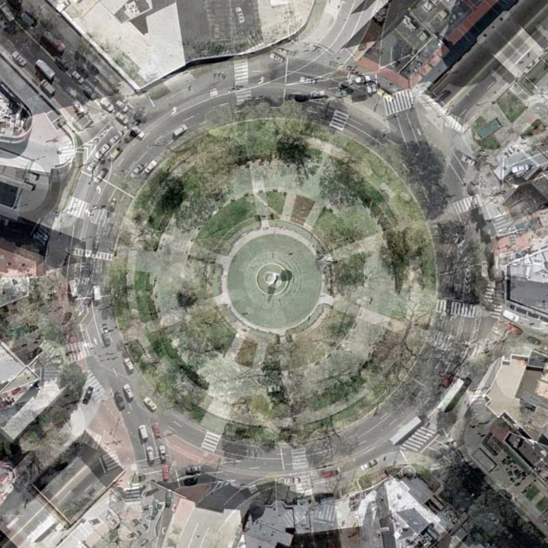
I decided to switch things up a bit with today’s rendering. I have become very efficient with most of the processes used to create my maps, which both makes them standardized and sometimes a bit too similar to each other (while paradoxically being different geographies). This map and probably the next few maps are going to be slightly different.

In order to have the most recent maps of Logan Circle, Dupont Circle, and Washington Circle look similar to each other, I would take the first derivative tessellation and overlay it on top of the tessellation that I was constructing. By adjusting the transparency, I can overlay the circles directly on top of each other which makes the subsequent map look nearly identical.

Normally, I simply delete the original tessellation when I have the two lined up perfectly, however in today’s map I chose to not delete the other map. Instead, I adjusted the transparency of Dupont Circle to 51% to show both geographies at once. The result is something that I wasn’t expecting, but am quite pleased with the results. I can see myself using this process again. It’s like a double exposure…

View the Google Map of Washington Circle in the Foggy Bottom neighborhood of Washington, DC.

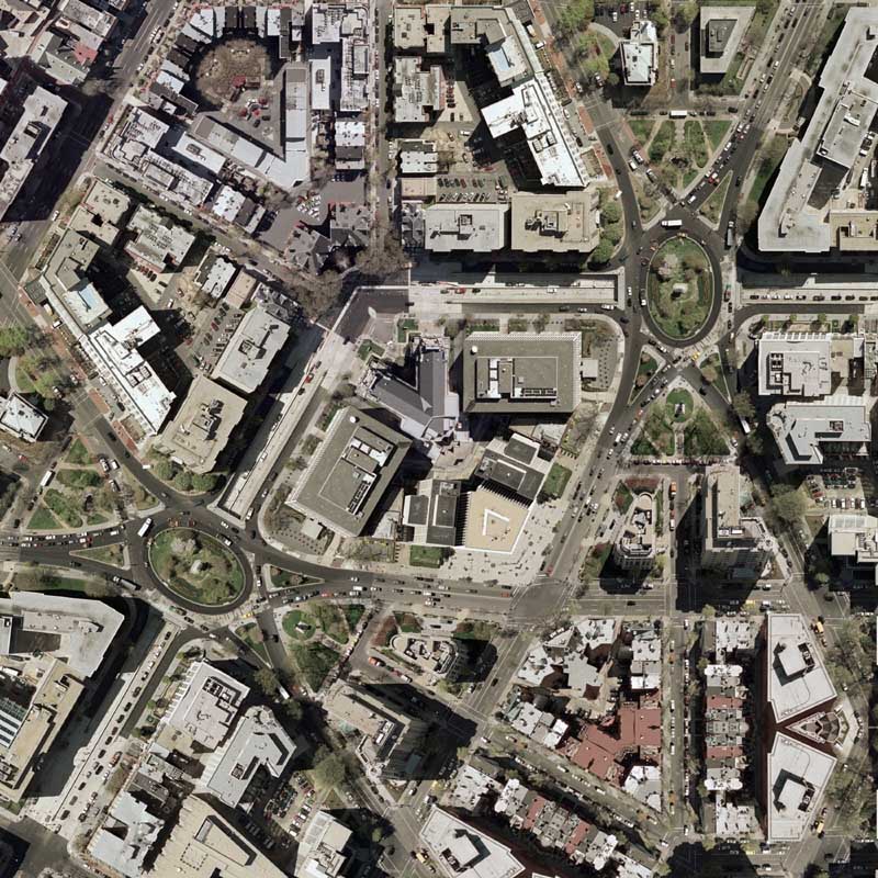
View the Google Map of Dupont Circle in Washington, DC.

View the rest of the details:

+ MORE


ESL Music website upgrade
|| 1/18/2008 || 11:17 pm || Comments Off on ESL Music website upgrade || ||

Screen Grab from the Supreme Illusion product page

Yesterday I was at The Consulate picking up copies of the record and I found that ESL Music has a new website up. Designed by Lightmaker, the website looks incredible. The intro banner animation is top notch! It makes me want to upgrade this website.


Cities & Nature is now available
|| 1/5/2008 || 1:35 pm || Comments Off on Cities & Nature is now available || ||

I look forward to seeing my copy when it arrives! The book cover uses my map of Central Park in New York City. From the screen grab above, the final design looks a bit greener than the original map, but I won’t know until I see my copy. Regardless, I genuinely look forward to reading it instead of fussing over the colors. What’s inside is what counts!


To be hung at a local gallery:
|| 12/20/2007 || 11:43 am || Comments Off on To be hung at a local gallery: || ||

Israel / Palestine 1993

“Israel / Palestine 1993”
Created July 3rd, 2006
Map Source: “Atlas of the Middle East” (1993) by the U.S. Central Intelligence Agency.
Courtesy of the Perry-Castañeda Library Map Collection at the University of Texas at Austin.
Cartoon Embellishment: “Handala” by Naji al-Ali (c. 1937 – 29 August 1987)

I signed the loan agreement papers earlier this week and placed an order for the printing of a 48″ x 32″ canvas print. I will post official information once I have the go-ahead.

+ MORE


Concentric Quilt NE
|| 12/6/2007 || 1:54 pm || Comments Off on Concentric Quilt NE || ||

: rendered at 18,000 X 12,000 :
Concentric Quilt - NE by Nikolas Schiller

Read more about this series here.

View Details:

+ MORE


My first album cover: Thievery Corporation – “Supreme Illusion”
|| 9/17/2007 || 1:06 pm || Comments Off on My first album cover: Thievery Corporation – “Supreme Illusion” || ||

I am very honored to have my first album cover be from DC-based, international recording artist, Thievery Corporation. They have been nominated twice for a Grammy Award for best package design and I personally feel that this album cover uniquely showcases their “outernational” style. Record cover features Lower Manhattan Quilt and Pentagon Quilt


Related Music Entries:

+ MORE


Google’s View of D.C. Melds New and Sharp, Old and Fuzzy – Washington Post
|| 7/22/2007 || 4:39 pm || Comments Off on Google’s View of D.C. Melds New and Sharp, Old and Fuzzy – Washington Post || ||


Today my analysis concerning Google’s censorship of downtown Washington, DC made it into a story on the front page of the Metro section of the Washington Post.

Here are two snippets from the article by Jenna Johnson titled, “Google’s View of D.C. Melds New and Sharp, Old and Fuzzy”

The older images frustrate cartographer Nikolas Schiller, 26, who takes an artistic approach to mapmaking and is working on an atlas. Schiller, who lives in the U Street area, said that too much of the District is represented using the older photos, diminishing the amount of information — and thrill — that aerial photos can provide.

“Maps are about power,” he said. “Maps decide what gets developed, who lives where, how people get around.”

Schiller said he thinks Google should just use the 2002 map for the small spots the government has censored rather than the whole downtown area.

And he said he’s puzzled that any level of blurriness is needed by anyone — even the government — especially because he recently took a detailed tour of a nuclear reactor south of Detroit via Google Earth.

“Where is the concept of national security in this?” he asked.

By random chance, tomorrow’s map is the nuclear reactor mentioned in the article.

Read the entire article:

+ MORE


The Daily Render By
A Digital Scrapbook for the Past, Present, and Future.

©2004-2026 Nikolas R. Schiller - Former Colonist of the District of Columbia - Privacy Policy - Fair Use - RSS - Contact


::LAST 51 POSTS::

Fair Use


50 queries. 3.196 seconds.
Powered by WordPress

Photo by Charlie McCormick
Hello! Thanks for stopping by! My name is Nikolas Schiller. I am an American citizen currently living in New York City and working remotely to support structural change in Washington, DC.

This blog is my online repository of what I have created or found online since May of 2004. I've been on hiatus since 2018 but plan on contributing more content in the not so distant future.

If you have any questions or comments, please contact:

If you would like to use content found here, please consult my Fair Use page.

::THE QUILT PROJECTION::

Square
Square

Diamond
diamond

Hexagon
hexagon

Octagon
octagon

Dodecagon
Dodecagon

Beyond
beyond

::OTHER PROJECTIONS::

The Lenz Project
Lenz

Mandala Project
Mandala

The Star Series


Abstract Series
abstract

Memory Series
Memory

Mother Earth Series
Mother Earth

Misc Renderings
Misc

::POPULAR MAPS::

- The Los Angeles Interchanges Series
- The Lost Series
- Terra Fermi
- Antique Map Mashups
- Google StreetView I.E.D.
- LOLmaps
- The Inaugural Map
- The Shanghai Map
- Ball of Destruction
- The Lenz Project - Maps at the Library of Congress
- Winner of the Everywhere Man Award

::MONTHLY ARCHIVES::


@NikolasSchiller

::LOCATIONS & CATEGORIES::

  • 2004 Elections (2)
  • 2008 Elections (35)
  • 2014 Elections (4)
  • 2016 Elections (2)
  • ACLU (3)
  • Activism (287)
  • Adbusters (13)
  • Advertisements (33)
  • aerial photography (19)
  • Analysis (31)
  • Animals (30)
  • animated gif (7)
  • Animation (25)
  • Antique (104)
  • Apple (1)
  • Arabic (17)
  • Architectural Archeology (9)
  • Artomatic (25)
  • Astronomy (15)
  • Astrophotography (9)
  • Audio (2)
  • Awards (3)
  • Backpacking (2)
  • banner graphics (5)
  • Beat Google to the Map (56)
  • bicycle (23)
  • Birds-Eye View (5)
  • Blaeu (10)
  • Book Covers (7)
  • Bridge (10)
  • Building (15)
  • calendar (28)
  • calligraphy (6)
  • Capital (61)
  • Cars (18)
  • Cartography (74)
  • Cartoon (9)
  • Celestial (31)
  • Censorship (32)
  • Chinese (7)
  • Chronicling America (34)
  • Classroom (5)
  • Clothing (12)
  • Commentary (76)
  • Commissioned (27)
  • Credit Cards (3)
  • Crime (12)
  • Cyrillic Alphabet (1)
  • DAILY LINKS (30)
  • Dance (2)
  • DC History (93)
  • Design (102)
  • Digital Scrap (5)
  • Election (11)
  • ESA (3)
  • Facebook (19)
  • Fantasy (3)
  • Fashion (23)
  • Fast Food (2)
  • FBI (7)
  • Flag (15)
  • flickr (4)
  • Found Map (56)
  • French (9)
  • Gallery (54)
  • Gardening (25)
  • General (256)
  • George Bush (12)
  • GIS (69)
  • GMO Labeling (4)
  • Google (31)
  • Google AdSense (4)
  • Google AdWords (3)
  • Google Earth (28)
  • Google Maps (47)
  • Google Reader (4)
  • Google Streetview (8)
  • GPS (7)
  • Graffiti (5)
  • Greek (4)
  • Green (72)
  • Green Party (18)
  • Healthcare (15)
  • Highway (35)
  • Hiking (2)
  • Hipster (2)
  • history (151)
  • Holidays (10)
  • House Party (2)
  • Hubble Telescope (2)
  • Humor (88)
  • In The News (88)
  • Insects (2)
  • Interactive (74)
  • Interiors (4)
  • IP Trace (28)
  • Latin (22)
  • Law (15)
  • Lecture (11)
  • Legislation (19)
  • Library (21)
  • Library of Congress (66)
  • Location (1,018)
  • LOLMaps (3)
  • Mass Transit (6)
  • Memorandum (2)
  • meta-data (32)
  • Mobile Phone Applications (1)
  • Movie (3)
  • MrSID (4)
  • MSN (5)
  • Museum (5)
  • Music (48)
  • MySpace (6)
  • NASA (10)
  • National Archives (3)
  • News (182)
  • Obituary (2)
  • Oil (4)
  • Ornithology (4)
  • orthophotography (4)
  • OSCE (16)
  • Photography (134)
  • Poetry (18)
  • Portuguese (1)
  • postmodern (8)
  • QR code (9)
  • QTVR (4)
  • Radio (3)
  • Renderings (675)
  • RSS (3)
  • Seasons (12)
  • Sold (40)
  • Spanish (7)
  • Speech (5)
  • Sports (1)
  • Stadium (40)
  • statehood (94)
  • Statistics (2)
  • Stellarium (4)
  • Stereogram (1)
  • Street (21)
  • Street Art (10)
  • Submissions (5)
  • Tattoo (2)
  • Testimony (2)
  • time-lapse (19)
  • Torture (3)
  • Transportation (6)
  • TV (23)
  • Twitter (5)
  • University (41)
  • Update (24)
  • Vegetarianism (2)
  • Video (49)
  • Vimeo (18)
  • visualization (36)
  • Washington Critic (2)
  • Weather (19)
  • Web Crawler (9)
  • Wikipedia (14)
  • Wordpress (4)
  • Wordpress Upgrade (2)
  • World Wind (3)
  • Yahoo (6)
  • YouTube (113)
  • Zodiac (23)


  • thank you,
    come again!