: rendered at 18,000 X 12,000 :

The other day I realized I hadn’t made any quilts of San Antonio, Texas yet….
View the Google Map of downtown San Antonio, Texas.
+ MORE
| FRONT PAGE |
GEOSPATIAL ART |
DC HISTORY / TIMELINE |
NEWS |
COLONIST |
FOUND MAPS |
FRACTALS |
|
PHOTOGRAPHY |
ANTIQUE |
DESIGN |
VIDEO |
|
CONTACT |
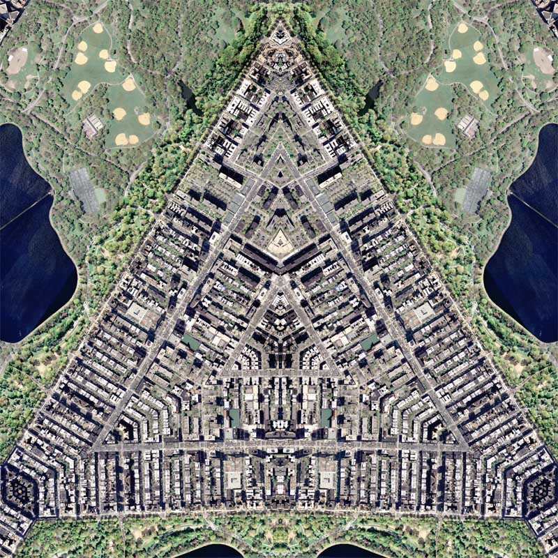
San Antonio Quilt
|| 5/4/2007 || 8:38 am || Comments Off on San Antonio Quilt || ||
The other day I realized I hadn’t made any quilts of San Antonio, Texas yet….
View the Google Map of downtown San Antonio, Texas.
+ MORE
Cities & Nature – My first book cover
|| 1/31/2007 || 12:20 am || Comments Off on Cities & Nature – My first book cover || ||
Today I received the payment from Routledge for the cover of a book titled “Cities & Nature” by my former professor Lisa Benton-Short and John Rennie-Short. It’s scheduled to be published on 11/28/07.
Details (w/o graphic)
Cities and Nature
Author(s) – Lisa Benton-Short, John Rennie-Short
Series: Routledge Critical Introductions to Urbanism and the CityIntroducing the reader to the city as part of the environment and so subject to environmental constraints and opportunities, this timely book is based on the claim that to fully understand the city we need to understand both the physical and social elements of the urban environment. Reintroducing a social science perspective to the examination of the city and its physical environment, the book is organized into three sections:
– urban environment in historical perspective
– issues in urban-nature relations
– realigning urban-nature relations.Illuminated throughout with thematic and place based cases from across the globe, the authors skilfully critique the dominant academic discourse that ignores the environmental base of urban life and living, and considers the urban natural environment as subject to social influences.
You can preorder the book here and here. I get a couple for free :)
Israel / Palestine 1993
|| 7/3/2006 || 3:59 pm || 1 Comment Rendered || ||

On Saturday day on I obtained a scanned map of Israel & Palestine from the “Atlas of the Middle East”, published in January 1993 by the U.S. Central Intelligence Agency. I was thinking of using the map for something quasi political, but this last week Israel blew up the only power plant in Gaza. An act identified as an international war crime where women, children, the sick, and eldery were all collectively punished through this illegal act on civilians. Israel also abducted 8 elected members of parliament. I can only imagine what it would be like if my city council members were kidnapped. Worse, my good friend was supposed to be going to Beruit next month and I don’t think she’ll be able to go now. I chose to add Naji al-Ali’s cartoon character Handala to this map as my way of showing shame.
From Wikipedia on Handala:
Handala is the most famous of Naji al-Ali’s characters. He is depicted as a ten-year old boy, and appeared for the first time in Al-Siyasa in Kuwait in 1969. The figure turned his back to the viewer from the year 1973, and clasped his hands behind his back. The artist explained that the ten-year old represented his age when forced to leave Palestine and would not grow up until he could return to his homeland; his turned back and clasped hands symbolised the character’s rejection of “outside solutions”. Handala wears ragged clothes and is barefoot, symbolising his allegiance to the poor. In later cartoons, he sometimes appears throwing stones or writing graffiti. Handala became the signature of Naji al-Ali’s cartoons and remains an iconic symbol of Palestinian identity and defiance; the artist remarked that “this being that I have invented will certainly not cease to exist after me, and perhaps it is no exaggeration to say that I will live on with him after my death”.
Yesterday I did run into a wayward and former Seeds of Peace camp counselor at the U-Haul. This did give me some hope…
View Map details:
Of interesting note, the map states clearly:
“The 1950 Israeli proclamation that Jerusalem be the national capital is not recognized by the United States Government”
I chose the placement of Handala so that his head surrounds Israel to point out focus of shame. By adding the character to the map, he becomes a cartoon cartouche. I am not aware of any contemporary maps that have iconic cartoon characters on them.

The points of the found star in the map are interesting. The confluence of the West Bank creates the tips and for some reason the C.I.A. chose to use odd stripes to show the West Bank as a country. Why not a normal whole color like every other country? Cartographic bias?
The best line from this section of the map is:
GAZA STRIP – Israeli occupied- status to be determined.


####
UPDATE 2/1/08
I am offering ten signed prints of ISRAEL / PALESTINE 1993 for sale at the gallery. Printed at 48″ x 32″ with archival inks on stretched canvas, the map is printed large enough so that you can read the tiny print on the original map.
If you are interested in attending the opening night reception, I have added an event invitation on Facebook where you can RSVP.
Harvard Quilt – NE
|| 3/2/2006 || 8:59 am || Comments Off on Harvard Quilt – NE || ||

A friend of mine that I have been spending a lot of time with lately graduated from Harvard a few years ago. When I told her that I was going to make a map of Harvard she showed me which dorm she lived in. When I set up the tessellation I tried my best to place her dorm, the Dunster House, near the seam on the NE & NW tessellations. The SE & SW tessellations placed her dorm on the edges of the tessellation, so I haven’t got around to making those two maps yet, but I plan on it.
One of my favorite aspects of my map making activities is seeing how the final product turns out. Where will the seams line up? What buildings will get reflected along a line of symmetry? What part of the map will be the most beautiful? Will I find a random reflection? etc. etc. It turns out that this map and the following map, have her former dorm placed beautifully. I also broke away from the standard 2 / 3 / 4 seamed maps, and made 6 seamed map, and I must say that I very happy with how this map turned out. Check the details to see what I’m talking about!
View the Google Map of Harvard University
View Details:
+ MORE
Harvard Quilt – NW
|| 3/1/2006 || 9:28 pm || Comments Off on Harvard Quilt – NW || ||

Read my comments from the Harvard Quilt NE here.
View the Google Map of Harvard University
View Details:

+ MORE
Atlanta Quilt
|| 2/22/2006 || 8:57 am || Comments Off on Atlanta Quilt || ||

This is the first iteration of a series of maps of downtown Atlanta, Georgia.
View the Google Map of Atlanta, Georgia
+ MORE
Chicago Quilt
|| 2/8/2006 || 9:04 am || Comments Off on Chicago Quilt || ||

So I’ve finally got around to making some maps of Chicago. I’ve had this imagery sitting on my computer for almost a year now, but I just never got around to tessellating it. I chose this location of downtown Chicago (view google map) because it is where the AAG’s Annual Meeting is going to take place next month.
Ideally, I’d like to have one of these printed out and maybe given away in a raffle similar to last year. Anyways, I am making a few different maps of Chicago. I have #2 finished rendering and #3 is in the pipeline. Tonight I will prepare both of them for tomorrow. I think it might be a good idea to snag some other imagery of Chicago to make my coverage of the city slightly better.
+ MORE
Mission Dolores Quilt #2
|| 12/25/2005 || 12:29 pm || Comments Off on Mission Dolores Quilt #2 || ||
Mission Dolores Quilt
|| 12/24/2005 || 2:25 pm || Comments Off on Mission Dolores Quilt || ||
Beverly Hills Quilt #4
|| 12/3/2005 || 12:03 pm || Comments Off on Beverly Hills Quilt #4 || ||

This is the final rendering of the series and I like it best. Comare it to Beverly Hills Quilt #2, which this rendering is the “inverse” of.
+ MORE
©2004-2026 Nikolas R. Schiller - Former Colonist of the District of Columbia - Privacy Policy - Fair Use - RSS - Contact
::LAST 51 POSTS::
50 queries. 0.471 seconds.
Powered by WordPress


::THE QUILT PROJECTION::
Square |
Diamond |
Hexagon |
Octagon |
Dodecagon |
Beyond |
::OTHER PROJECTIONS::
The Lenz Project |
Mandala Project |
The Star Series |
Abstract Series |
Memory Series
|
Mother Earth Series
|
|
Misc Renderings
 |
::POPULAR MAPS::
- The Los Angeles Interchanges Series::MONTHLY ARCHIVES::
::LOCATIONS & CATEGORIES::

