The Daily Render

by

A Digital Scrapbook for the Past, Present, and Future

| FRONT PAGE | GEOSPATIAL ART | DC HISTORY / TIMELINE | NEWS | COLONIST | FOUND MAPS | FRACTALS |
| PHOTOGRAPHY | ANTIQUE | DESIGN | VIDEO | | CONTACT |

Who Carries 8 Quarters? Photographs of the Wall Street Journal Newspaper Vending Machine Which Takes Credit Cards
|| 9/26/2009 || 4:42 pm || 1 Comment Rendered || ||

Photograph of the Wall Street Journal Newspaper Vending Machine

The other day I was outside of a Metro station in Clarendon, Virginia and noticed this unique Wall Street Journal vending machine. Its the first time I’ve seen a newspaper vending machine take credit cards. But then again, who carries 8 quarters in their pocket?

View the other two photos:

+ MORE


The Pentagon Timelapse Animated GIF (2001-2005)
|| 9/1/2009 || 5:00 pm || + Render A Comment || ||

Still frame from The Pentagon Timelapse Animated GIF featuring USGS aerial photography from 2005Still frame from The Pentagon Timelapse Animated GIF featuring USGS aerial photography from 2005
Click the image above to watch the animation

Last night I was going through one of my external hard drives and rediscovered a cache of “old” satellite imagery. I rarely publish any entries that use satellite imagery due to copyright issues because, generally speaking, the company that owns the satellite also owns all the pixels and this prevents me from legally creating derivative works. Today, however, I decided to test the boundaries with this legacy satellite imagery of the Pentagon and feel that this creation is protected under the fair use doctrine of US copyright law. You can always contact GeoEye if you are interested in purchasing satellite imagery from the IKONOS satellite.

The Animated GIF below features 9 frames consisting of 7 satellite images from the IKONOS Satellite (2001-2002) and two public domain aerial photographs from the USGS (2002 & 2005). It begins with satellite imagery taken four days before 9/11/01 and ends with a USGS aerial photograph taken in September 2005. The frames in between show the aftermath and the subsequent rebuilding of the Pentagon. I did my best to line up the building in my image editing program, but it’s not 100% perfect due to the angle in which some of the imagery was taken.


I have chosen to place the The Pentagon Timelapse Animated GIF “below the fold” so that visitors to the front page of this website are not downloading the somewhat large file. Please be patient while it downloads……

+ MORE


An Act for establishing the Temporary and Permanent seat of the Government of the United States
|| 2/24/2009 || 12:35 pm || Comments Off on An Act for establishing the Temporary and Permanent seat of the Government of the United States || ||

For last month or so I’ve been adding historic pieces of legislation here on my blog. The aim here, and the general aim of this blog, is to keep an ongoing, on-line journal that features things that I’m either interested in or things that I have created. Historic pieces of legislation related to the District of Columbia fall into the former category, and today’s entry is the text & scans of the act that established the Temporary (Philadelphia) and Permanent Seat of the Government of the United States in a “district of territory” that would eventually become named the District of Columbia.


+ MORE


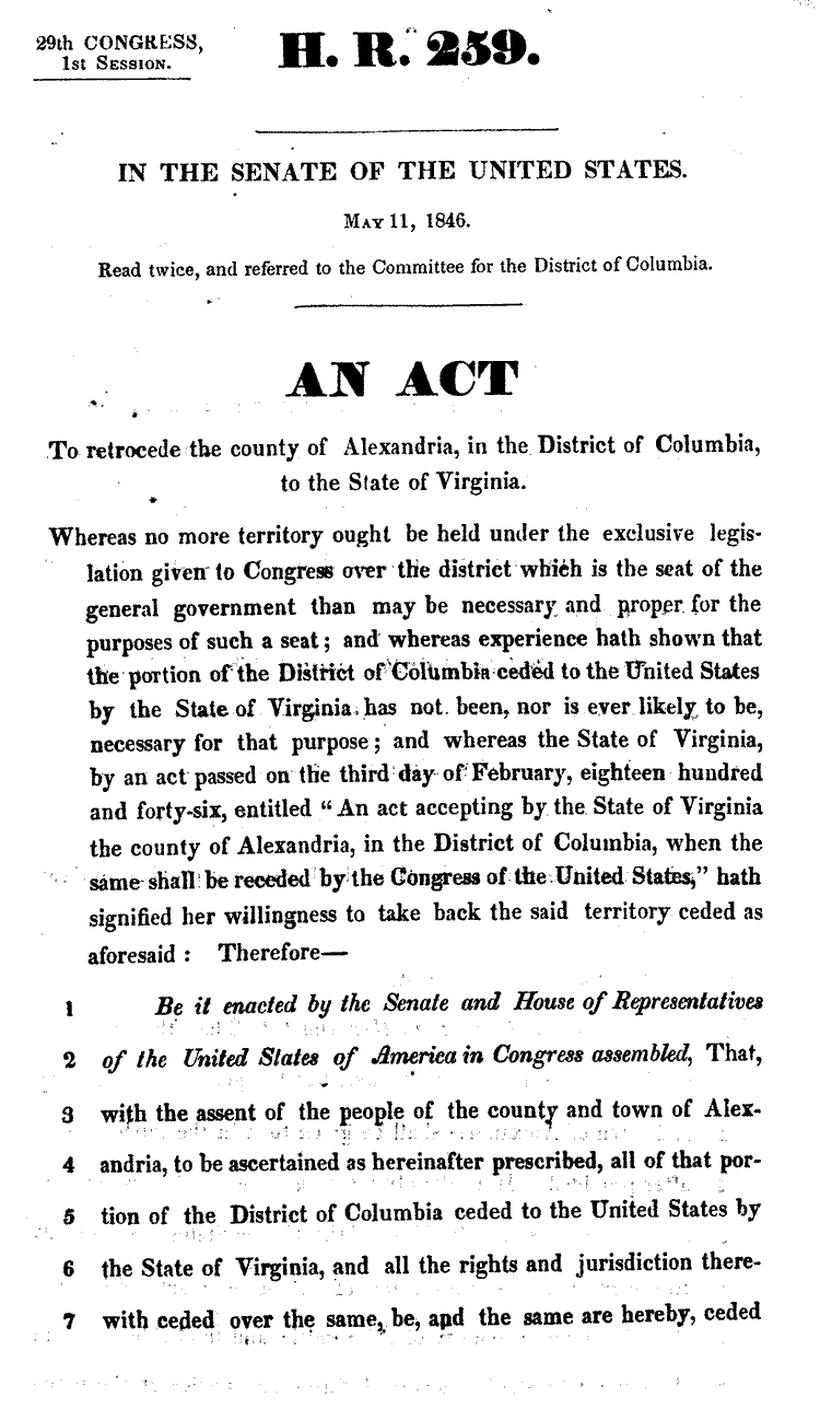
Text of H.R. 259 – An act to retrocede the county of Alexandria, in the District of Columbia, to the State of Virginia
|| 2/19/2009 || 7:12 pm || 1 Comment Rendered || ||

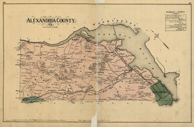
From 1840 to 1846, residents of Alexandria petitioned Congress and the Virginia legislature to approve retrocession. On February 3, 1846 the Virginia General Assembly agreed to accept the retrocession of Alexandria if Congress approved. Following additional lobbying by Alexandrians, Congress passed legislation (below) on July 9, 1846 to return all the District’s territory south of the Potomac River back to the Commonwealth of Virginia, pursuant to a referendum that would be held later in the year, and President Polk signed this first piece of legislation the next day.

A referendum on retrocession was then held on September 1–2, 1846 and the residents of the City of Alexandria voted in favor of the retrocession, 734 to 116, however, the residents of Alexandria County voted against retrocession 106 to 29. Despite the objections of those living in Alexandria County, President Polk certified the referendum and issued a proclamation of transfer on September 7, 1846. However, the Virginia legislature did not immediately accept the retrocession offer. Virginia legislators were concerned that the people of Alexandria County had not been properly included in the retrocession proceedings. After months of debate, the Virginia General Assembly voted to formally accept the retrocession legislation on March 13, 1847.

In Abraham Lincoln’s first State of the Union, delivered on December 3, 1861, he suggested restoring the District of Columbia to George Washington’s original boundaries:

The present insurrection [Civil War] shows, I think, that the extension of this District across the Potomac at the time of establishing the capital here was eminently wise, and consequently that the relinquishment of that portion of it which lies within the state of Virginia was unwise and dangerous. I submit for your consideration the expediency of regarding that part of the District and the restoration of the original boundaries thereof through negotiations with the State of Virginia.

I also question the legitimacy of the retrocession because in the bill below you can see that it states that both the county AND the town of Alexandria were to pass the referendum. The county of Alexandria never voted in favor of retrocession, only the town voted for it. Imagine if the land was returned back to the District of Columbia?

Continue:

+ MORE


[Commission] Shirlington Quilt
|| 10/15/2008 || 6:16 pm || Comments Off on [Commission] Shirlington Quilt || ||

: rendered at 9,000 X 6,000 :

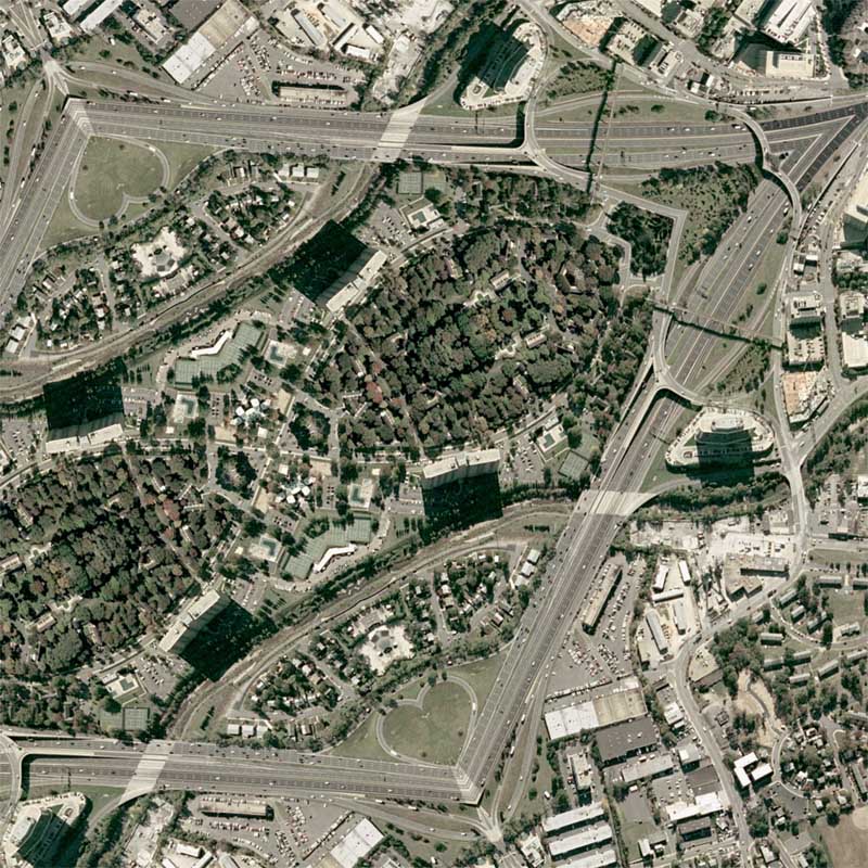
I’ve been working on this commissioned map for a few months now. It was originally going to be Paris, but we decided to it would be easier to make a map of their house. I spent some extra time transforming the nearby highway into a heart (below) to signify the love between the husband and wife. I think it looks beautiful :-) It will be placed in the client’s home, which is featured within the map.

View the Google Map of the Shirlington neighborhood of Arlington, Virginia.

: detail :

View the rest of the details:

+ MORE


Of (the Tartars) manners both good and bad (around 400 years ago)
|| 4/19/2008 || 3:26 pm || Comments Off on Of (the Tartars) manners both good and bad (around 400 years ago) || ||

1732 Map of Great Tartary by Herman Moll
Obtained from the David Rumsey Map Collection

Today’s entry follows up my successful layout of Ovid’s Remedia Amoris / The Cure for Love and employs the same side by side Latin / English text. Below you will find Chapter 5 of Richard Hakluyt’s The Principal Navigations, Voiages, Traffiques and Discoueries of the English Nation – Volume 2 published 1598-1600 in London, England.

Richard Hakluyt was an English author, editor, translator, and personal chaplain to Sir Robert Cecil, 1st Earl of Salisbury, principal Secretary of State to Elizabeth I and James I. A great history of his life and works can be found in his Wikipedia entry. Most notably, he was one of the biggest advocates for English colonization of Virginia. Some of his other exploration-related works include the Discovery of Muscovy, Voyagers Tales, Voyages in Searth of the North-West Passage, and numerous similar volumes related to The Principal Navigations, Voiages, Traffiques and Discoueries of the English Nation (Project Gutenberg lists a total of 12 volumes altogether).

In the chapter below he describes the manners of the people of Tartary. This antiquated geographic name was used by Europeans from the Middle Ages until the twentieth century to designate the great tract of northern and central Asia stretching from the Caspian Sea and the Ural Mountains to the Pacific Ocean (see map above). Inhabited by Turkic and Mongol peoples of the Mongol Empire who were generically referred to as “Tartars”, the present day geography includes the current areas of Siberia, Turkestan (including East Turkestan), Greater Mongolia, and parts China. In many ways the book reminds me of how an antiquarian National Geographic article might have read. The aim of this book, and many of his other works, was to consolidate what others had written about different regions around the known world and in doing so help spread the diffusion of geographic & ethnographic knowledge.

Lastly, in regards to the transcription below, I did not modify the original Project Gutenberg text, so when reading please note that there are some typographic differences in the old English and contemporary English. Remember to change the lowercase V to a lowercase U and in some cases, change the I’s to J’s. I did consider updating the text to modern English, but in some ways I feel that it would be better to keep the text in it’s originally transcribed format. Unlike Ovid’s Remedia Amoris / The Cure for Love, I did not include the line numbers because they were not given in the original text. I did, however, separate the text into easy to read paragraphs. If you are reading this entry via Google Reader, the chapter can be better read by hiding the sidebar that shows your subscriptions by clicking the small arrow on the left separator or by pressing “u” on your keyboard to switch to wide screen.

I hope you enjoy reading it as much as I did:

+ MORE


My first album cover: Thievery Corporation – “Supreme Illusion”
|| 9/17/2007 || 1:06 pm || Comments Off on My first album cover: Thievery Corporation – “Supreme Illusion” || ||

I am very honored to have my first album cover be from DC-based, international recording artist, Thievery Corporation. They have been nominated twice for a Grammy Award for best package design and I personally feel that this album cover uniquely showcases their “outernational” style. Record cover features Lower Manhattan Quilt and Pentagon Quilt


Related Music Entries:

+ MORE


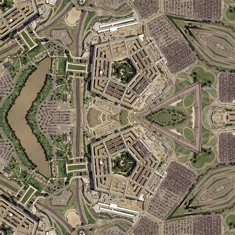
Pentagon Quilt #2
|| 4/23/2006 || 8:01 am || Comments Off on Pentagon Quilt #2 || ||

: rendered at 18,000 X 12,000 :

I might made another that creates a hexagon or an octogon out of the Pentagon. I think it would look really cool :-)

View the Google Map of the Pentagon

: zoom out from center :

View Details:

+ MORE


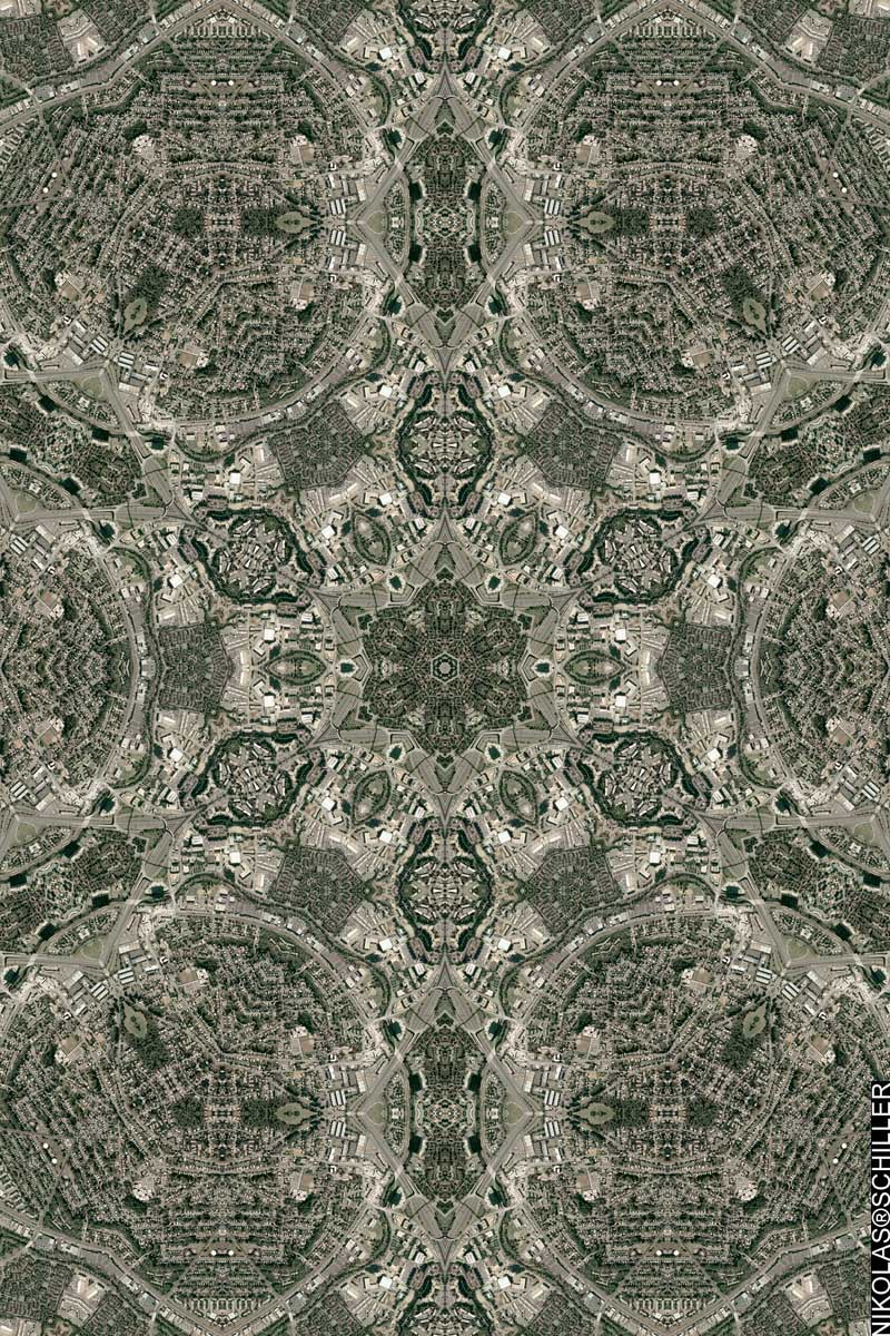
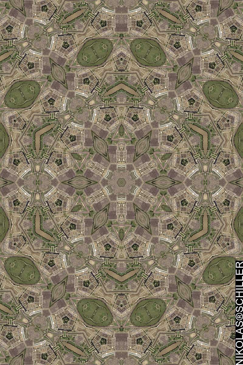
Pentagon Quilt
|| 4/22/2006 || 8:42 am || Comments Off on Pentagon Quilt || ||

: rendered at 18,000 X 12,000 :
Pentagon Quilt by Nikolas Schiller

I’ve decided to venture over the Potomac River and make a few maps of the Washington, DC hinterland. Up next will be Rosslyn and the CIA building.

I don’t know why I decided to make maps of the Pentagon & CIA, but I figured why not just focus on a couple buildings? Most of my maps are comprised of specific areas instead of specific buildings, so in some respects, while they are not technically different, these two maps are a slight departure from the norm.

View the Google Map of the Pentagon

: detail :

View the rest of the details:

+ MORE


ISO – La Haine
|| 11/8/2005 || 7:59 am || Comments Off on ISO – La Haine || ||

So last night while I was coding my “Geospatial Art” layer for Google Earth, I decided to attempt to find a copy of “La Haine,” online, and of course I couldn’t! The film was recently released on DVD, but only with Region 2 encoding (WTF!). I decided to put a posting on craigslist about it the film, and hopefully someone will respond…. I really want to see the film again!

I was thinking about synergistic events and how the riots in France could easily be replicated here in Washington, DC. Granted I am not one to cause destruction of other people’s belongings, read: I am NOT going to do this, but I was thinking last night how poignant it would be to see the marginalized residents of SE Washington, DC burning cars to show the world that poverty exists here in DC as well. The most far-fetched idea that someone came up with was burning 51 cars from Virginia & Maryland in the confines of DC. The 51 cars would represent DC as the 51st state, and the synergistic aspect to this theoretical vandalism is the Supreme Court ruling last week that struck down the commuter tax the District hoped to impose on Maryland & Virginia drivers. Essentially, DC residents are marginalized both economically (some residents) and democratically (all residents), and the destruction of cars from Maryland & Virginia would show the world that the residents are fed up and beginning to fight back.


The Daily Render By
A Digital Scrapbook for the Past, Present, and Future.

©2004-2023 Nikolas R. Schiller - Colonist of the District of Columbia - Privacy Policy - Fair Use - RSS - Contact


::LAST 51 POSTS::

Fair Use


51 queries. 0.674 seconds.
Powered by WordPress

Photo by Charlie McCormick
Nikolas Schiller is a second-class American citizen living in America's last colony, Washington, DC. This blog is my on-line repository of what I have created or found on-line since May of 2004. If you have any questions or comments, please contact:

If you would like to use content found here, please consult my Fair Use page.

::THE QUILT PROJECTION::

Square
Square

Diamond
diamond

Hexagon
hexagon

Octagon
octagon

Dodecagon
Dodecagon

Beyond
beyond

::OTHER PROJECTIONS::

The Lenz Project
Lenz

Mandala Project
Mandala

The Star Series


Abstract Series
abstract

Memory Series
Memory

Mother Earth Series
Mother Earth

Misc Renderings
Misc

::POPULAR MAPS::

- The Los Angeles Interchanges Series
- The Lost Series
- Terra Fermi
- Antique Map Mashups
- Google StreetView I.E.D.
- LOLmaps
- The Inaugural Map
- The Shanghai Map
- Ball of Destruction
- The Lenz Project - Maps at the Library of Congress
- Winner of the Everywhere Man Award

::MONTHLY ARCHIVES::


::LOCATIONS & CATEGORIES::

  • 2004 Elections (2)
  • 2008 Elections (35)
  • 2014 Elections (4)
  • 2016 Elections (2)
  • ACLU (3)
  • Activism (287)
  • Adbusters (13)
  • Advertisements (33)
  • aerial photography (19)
  • Analysis (31)
  • Animals (30)
  • animated gif (7)
  • Animation (25)
  • Antique (104)
  • Apple (1)
  • Arabic (17)
  • Architectural Archeology (9)
  • Artomatic (25)
  • Astronomy (15)
  • Astrophotography (9)
  • Audio (2)
  • Awards (3)
  • Backpacking (2)
  • banner graphics (5)
  • Beat Google to the Map (56)
  • bicycle (23)
  • Birds-Eye View (5)
  • Blaeu (10)
  • Book Covers (7)
  • Bridge (10)
  • Building (15)
  • calendar (28)
  • calligraphy (6)
  • Capital (61)
  • Cars (18)
  • Cartography (74)
  • Cartoon (9)
  • Celestial (31)
  • Censorship (32)
  • Chinese (7)
  • Chronicling America (34)
  • Classroom (5)
  • Clothing (12)
  • Commentary (76)
  • Commissioned (27)
  • Credit Cards (3)
  • Crime (12)
  • Cyrillic Alphabet (1)
  • DAILY LINKS (30)
  • Dance (2)
  • DC History (93)
  • Design (102)
  • Digital Scrap (5)
  • Election (11)
  • ESA (3)
  • Facebook (19)
  • Fantasy (3)
  • Fashion (23)
  • Fast Food (2)
  • FBI (7)
  • Flag (15)
  • flickr (4)
  • Found Map (56)
  • French (9)
  • Gallery (54)
  • Gardening (25)
  • General (256)
  • George Bush (12)
  • GIS (69)
  • GMO Labeling (4)
  • Google (31)
  • Google AdSense (4)
  • Google AdWords (3)
  • Google Earth (28)
  • Google Maps (47)
  • Google Reader (4)
  • Google Streetview (8)
  • GPS (7)
  • Graffiti (5)
  • Greek (4)
  • Green (72)
  • Green Party (18)
  • Healthcare (15)
  • Highway (35)
  • Hiking (2)
  • Hipster (2)
  • history (151)
  • Holidays (10)
  • House Party (2)
  • Hubble Telescope (2)
  • Humor (88)
  • In The News (88)
  • Insects (2)
  • Interactive (74)
  • Interiors (4)
  • IP Trace (28)
  • Latin (22)
  • Law (15)
  • Lecture (11)
  • Legislation (19)
  • Library (21)
  • Library of Congress (66)
  • Location (1,018)
  • LOLMaps (3)
  • Mass Transit (6)
  • Memorandum (2)
  • meta-data (32)
  • Mobile Phone Applications (1)
  • Movie (3)
  • MrSID (4)
  • MSN (5)
  • Museum (5)
  • Music (48)
  • MySpace (6)
  • NASA (10)
  • National Archives (3)
  • News (182)
  • Obituary (2)
  • Oil (4)
  • Ornithology (4)
  • orthophotography (4)
  • OSCE (16)
  • Photography (134)
  • Poetry (18)
  • Portuguese (1)
  • postmodern (8)
  • QR code (9)
  • QTVR (4)
  • Radio (3)
  • Renderings (675)
  • RSS (3)
  • Seasons (12)
  • Sold (40)
  • Spanish (7)
  • Speech (5)
  • Sports (1)
  • Stadium (40)
  • statehood (94)
  • Statistics (2)
  • Stellarium (4)
  • Stereogram (1)
  • Street (21)
  • Street Art (10)
  • Submissions (5)
  • Tattoo (2)
  • Testimony (2)
  • time-lapse (19)
  • Torture (3)
  • Transportation (6)
  • TV (23)
  • Twitter (5)
  • University (41)
  • Update (24)
  • Vegetarianism (2)
  • Video (49)
  • Vimeo (18)
  • visualization (36)
  • Washington Critic (2)
  • Weather (19)
  • Web Crawler (9)
  • Wikipedia (14)
  • Wordpress (4)
  • Wordpress Upgrade (2)
  • World Wind (3)
  • Yahoo (6)
  • YouTube (113)
  • Zodiac (23)


  • thank you,
    come again!