: rendered at 18,000 X 12,000 :

Using a portion of Madison Offset, I created a couple more tessellations and ultimately this fractal Octagon Quilt Projection Map.
View the Google Map of Madison, Wisconsin.
: detail :

+ MORE
| FRONT PAGE |
GEOSPATIAL ART |
DC HISTORY / TIMELINE |
NEWS |
COLONIST |
FOUND MAPS |
FRACTALS |
|
PHOTOGRAPHY |
ANTIQUE |
DESIGN |
VIDEO |
|
CONTACT |
Madison Quilt
|| 3/8/2011 || 4:03 pm || Comments Off on Madison Quilt || ||
Using a portion of Madison Offset, I created a couple more tessellations and ultimately this fractal Octagon Quilt Projection Map.
View the Google Map of Madison, Wisconsin.
+ MORE
DFW Quilt #2
|| 6/8/2010 || 1:40 pm || Comments Off on DFW Quilt #2 || ||

Using a portion of DFW Quilt, I created this recursively sampled Octagon Quilt projection map. The muted tones from the airport’s concrete tarmac contrasted with the planes and the built environment make this quite a unique map.
View the Google Map of Dallas-Fort Worth International Airport.

+ MORE
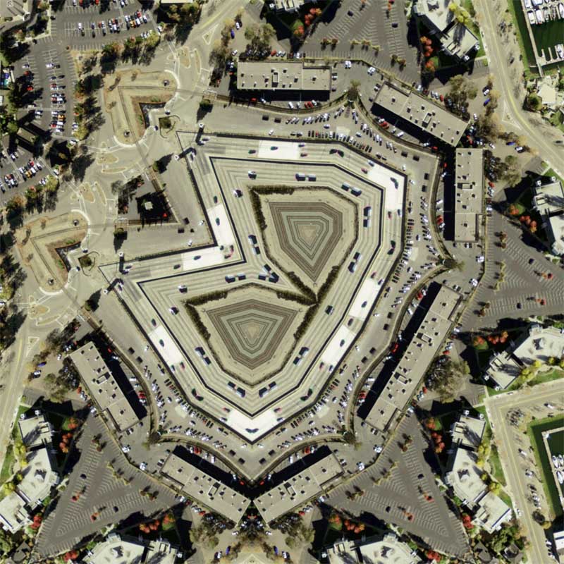
Harborside Quilt #3
|| 2/19/2010 || 1:45 pm || 1 Comment Rendered || ||

This final edition is derived from sampled imagery from the previous two renderings. I chose the layout for this version based on the beautiful geometric design that is created at the center of the map. These two recursive samplings have created an almost crystalline map of the area.
View the Google Map of Oakland Habour.
Here’s another YouTube video that shows Harborside Health Center on KTVU:
+ MORE
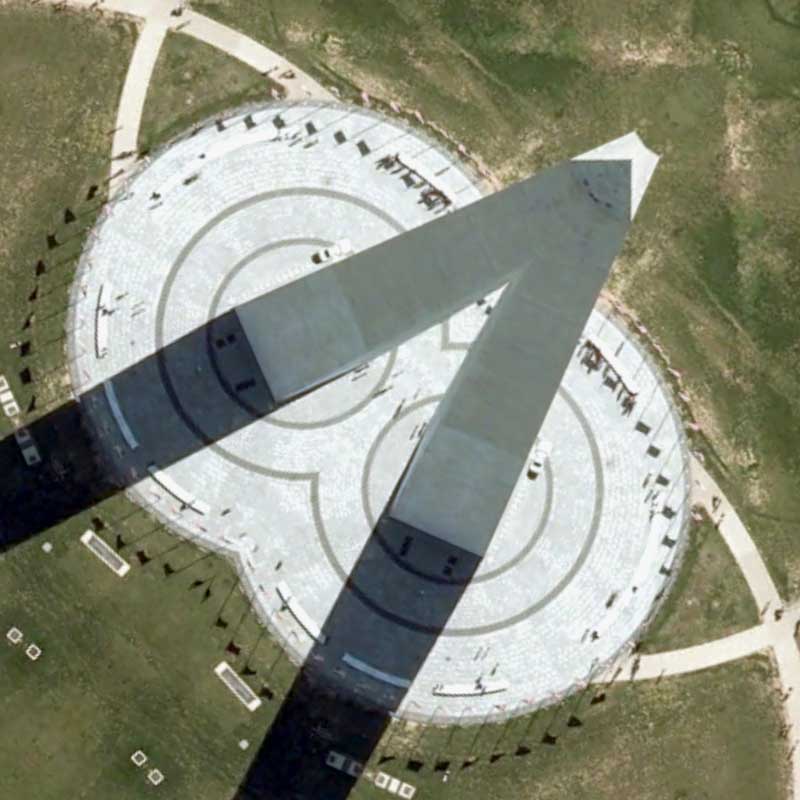
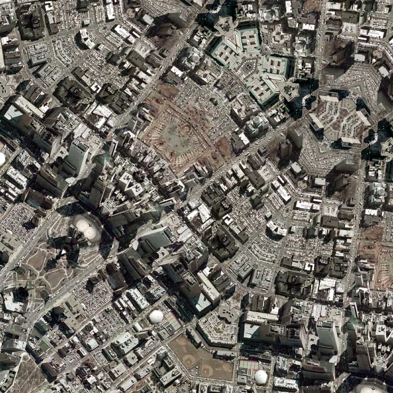
Washington Monument Quilt #2
|| 10/22/2009 || 5:22 pm || Comments Off on Washington Monument Quilt #2 || ||

When the 2005 USGS aerial photography was released to the public in the spring of 2007 there were a few places that were censored through pixilation. On this blog I documented how the White House was censored. I documented how the U.S. Capitol was censored. And I even experimented with a QR-Code to show that the Washington Monument was censored. After doing some exploration within the newly obtained 2008 Washington, DC orthophotography, I discovered that the White House and the U.S. Capitol are STILL censored.
However, now that the construction of the new visitors center at the Washington Monument has been completed, which is the reason, I am told, why the Washington Monument was originally censored in the 2005 imagery, the imagery of the monument is now available without pixilation. Moreover, its the exact same imagery that is being used on Google Maps. While I expect to showcase the censorship of the White House & U.S. Capitol in some future entries, I decided to make make my first map of this new dataset of the Washington Monument because I wasn’t able to make it using the last batch of imagery.
To construct this map, I first rendered a full-size Hexagon Quilt Projection map using the original imagery, then sampled a portion of the resulting map, and used the sampled portion to create this derivative map. I chose to sample the portion in the first map because of two underlying aspects of the map. First, I really liked the way the shadows of the Washington Monument combined together. Secondly, I liked the way the apex of the Washington Monument was combined (see detail below) to create a pyramid. Over the years I have enjoyed playing with the notion of aerial & architectural chiaroscuro, as in, using shadows generated by buildings within the original aerial photography to create a new, larger shadow. This map embodies this ongoing design element perfectly.
View the Google Map of the Washington Monument on the National Mall in Washington, DC.
+ MORE
National Gallery of Art Sculpture Garden Quilt [COMMISSIONED MAP]
|| 10/16/2009 || 3:11 pm || Comments Off on National Gallery of Art Sculpture Garden Quilt [COMMISSIONED MAP] || ||

After making eight different drafts, the client liked a modified version the best. Using derivative imagery from Draft #4, I was able to create the map above. It features the area around the fountain at the National Gallery of Art Sculpture Garden on the National Mall in Washington, DC. The client is having this map printed at 20″ x 16″ so the final printed version will look slightly different than the version above. As always, contact me if you interested in having a custom map created for you.

+ MORE
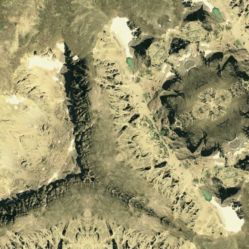
Front Range Quilt #2
|| 6/20/2009 || 10:15 pm || Comments Off on Front Range Quilt #2 || ||
Using this portion of Front Range Quilt, I created this derivative map. I sampled that portion because I like the nature of how the shadows of the ridge presented themselves and I wanted to include the tarn at the base of Andrews Glacier. I opted for the Dodecagon Quilt Projection because I felt it that it would work nicely since I am not trying to capture any specific buildings or streets in the source imagery (there are none!).
View the Google Map of the Front Range in Rocky Mountain National Park in Colorado.

View the rest of the map details:
+ MORE
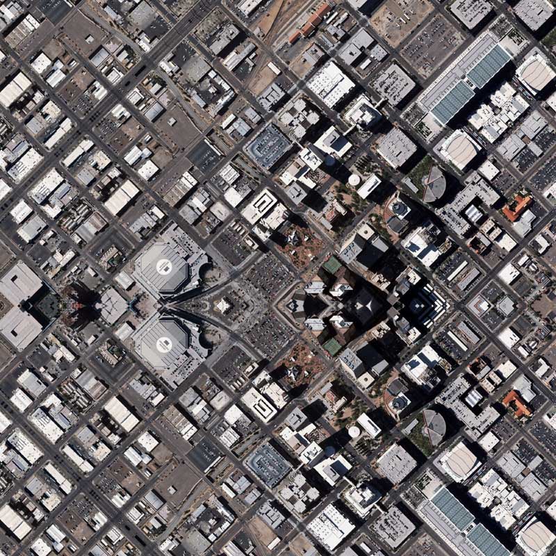
Phoenix Quilt #2
|| 4/11/2009 || 6:24 pm || Comments Off on Phoenix Quilt #2 || ||

Using this portion of Phoenix Quilt, I created this derivative map of downtown Phoenix, Arizona. For this map I decided to employ the Dodecagon Quilt Projection because its been a little while since I’ve used that projection. I also liked the way the rooftop of the Sandra Day O’Connor US District Court creates a nice design around the center.
View the Google Map of downtown Phoenix, Arizona

View the rest of the map details:
+ MORE
Newark Quilt #2
|| 12/13/2008 || 10:04 pm || Comments Off on Newark Quilt #2 || ||

Using this portion of Newark Quilt, I was able to constructive this Hexagon Quilt Projection derivative map. If you look closely there is a nice hexagram in the center of the map. I’d like to make a map of Trenton, New Jersey next.
View the Google Map of downtown Newark, New Jersey

+ MORE
Eye 670 – A perspective of Interstate 670 in downtown Kansas City
|| 12/10/2008 || 3:04 pm || Comments Off on Eye 670 – A perspective of Interstate 670 in downtown Kansas City || ||

Using this portion of Kansas City Quilt #2, I created this derivative map of downtown Kansas City, Missouri. This map is a unique map because it features aspects of the Lenz Projection and the Quilt Projection combined to create what looks like a human eye. By combing what it looks like with the location, I-670, the name of this map becomes a play on words.
View the Google Map of downtown Kansas City, Missouri

+ MORE
©2004-2026 Nikolas R. Schiller - Former Colonist of the District of Columbia - Privacy Policy - Fair Use - RSS - Contact
::LAST 51 POSTS::
49 queries. 0.429 seconds.
Powered by WordPress


::THE QUILT PROJECTION::
Square |
Diamond |
Hexagon |
Octagon |
Dodecagon |
Beyond |
::OTHER PROJECTIONS::
The Lenz Project |
Mandala Project |
The Star Series |
Abstract Series |
Memory Series
|
Mother Earth Series
|
|
Misc Renderings
 |
::POPULAR MAPS::
- The Los Angeles Interchanges Series::MONTHLY ARCHIVES::
::LOCATIONS & CATEGORIES::