The Daily Render

by

A Digital Scrapbook for the Past, Present, and Future

| FRONT PAGE | GEOSPATIAL ART | DC HISTORY / TIMELINE | NEWS | COLONIST | FOUND MAPS | FRACTALS |
| PHOTOGRAPHY | ANTIQUE | DESIGN | VIDEO | | CONTACT |

A Navy Yard Perspective
|| 5/30/2009 || 1:43 pm || 1 Comment Rendered || ||

: rendered at 9,000 X 6,000 :
A Navy Yard Perspective by Nikolas R. Schiller

While on blogging hiatus, I made this map on May 12th, but didn’t post it. I don’t really have any rationale for not posting it except that I wanted to take a month off from blogging to see where my daily visitor threshold was; as in finding how many people visited my website without daily blogging. So in order to ascertain the data, I purposely withheld this entry.

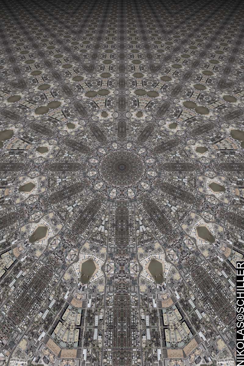
Following up last year’s Artomatic maps, which also featured the area prior to development, I decided to try something a little different. When making this map I spent a lot of time working with the field of view parameters to create the depth of perspective. In the foreground (the lower half) you have a somewhat close-up view of the area around the Navy Yard Metro station in Southeast, Washington, DC and in the upper half you have a larger field of view that appears to stretch out to infinite. The aerial photography was taken in the spring of 2005 before the stadium and subsequent nearby development had been completed. Even if you look at the current Google Maps of the area, the construction of this year’s Artomatic venue had not even began.


View the Google Map of the Navy Yard in Washington, DC, which features newer imagery

: detail of the Navy Yard Metro prior to construction :

View the rest of the map details:

+ MORE


Fashion District Quilt #2
|| 4/17/2009 || 7:06 pm || Comments Off on Fashion District Quilt #2 || ||

: rendered at 18,000 X 12,000 :
Fashion District Quilt 2 by Nikolas R. Schiller

Using this portion of Fashion District Quilt, I composed this derivative map. I chose this layout because I liked the way the tessellation created almost-circular building clusters.


View the Google Map of the Fashion District in Los Angeles, California

: detail :

View the rest of the map details:

+ MORE


Fashion District Quilt
|| 4/16/2009 || 6:25 pm || Comments Off on Fashion District Quilt || ||

: rendered at 18,000 X 12,000 :
Fashion District Quilt by Nikolas R. Schiller

As I was doing research for the upcoming exhibition in Los Angeles, I decided to map out the area around the Gallery 727. After consulting a few different maps, I found that the gallery is technically located in the area known as the Fashion District, albeit on the periphery. Google Maps lists the area as the Historic Core, but I don’t think “Historic Core Quilt” has a good ring to it. I chose the Octagon Quilt Projection because I like the way the shadows in the streets form a compass rose around the center of the map.


View the Google Map of the Fashion District in Los Angeles, California

: detail :

View the rest of the map details:

+ MORE


Phoenix Quilt #2
|| 4/11/2009 || 6:24 pm || Comments Off on Phoenix Quilt #2 || ||

: rendered at 18,000 X 12,000 :
Phoenix Quilt 2 by Nikolas R. Schiller

Using this portion of Phoenix Quilt, I created this derivative map of downtown Phoenix, Arizona. For this map I decided to employ the Dodecagon Quilt Projection because its been a little while since I’ve used that projection. I also liked the way the rooftop of the Sandra Day O’Connor US District Court creates a nice design around the center.


View the Google Map of downtown Phoenix, Arizona

: detail :

View the rest of the map details:

+ MORE


Phoenix Quilt
|| 4/9/2009 || 12:31 pm || Comments Off on Phoenix Quilt || ||

: rendered at 18,000 X 12,000 :
Phoenix Quilt by Nikolas R. Schiller

Over the years I’ve done my best to map every major city throughout the United States. Some cities & states withhold their imagery from the public domain and I’ve been unable to map those geographies (I’m looking you at Vermont!). While Tuscon, Arizona was released to the public a few years back, Phoenix, the primary city of Arizona, was not released until sometime last year. I don’t get updates of when new imagery is released in the public domain, which has kept me in the dark about when other cities are releasing new imagery, otherwise I would have mapped Phoenix sooner.

For this map I decided to employ the Diamond Quilt Projection on the area around downtown Phoenix. The source aerial photography was originally .8 feet per pixel, but in order to capture more of the downtown area I reduced the spatial resolution of the source imagery to cover more area. In doing so, I have most of the important buildings in downtown Phoenix. Known as Cooper Square, the buildings in this map include Chase Field, U.S. Airways Center, Sandra Day O’Connor US District Court, Bank of America Tower, City Hall, Maricopa County government buildings, Phoenix Civic Center, and Patriot Square Park. Unlike most of my state capital maps, the Phoenix state capitol is located to the west and I will probably have to go back and make a subsequent map so I can include it in my ongoing series of state capitol buildings.

Anyways, I resampled a portion of this map and will post it tomorrow.


View the Google Map of downtown Phoenix, Arizona

: detail :

View the rest of the map details:

+ MORE


A Gigapan of Erie Coke Corporation Eye
|| 3/22/2009 || 4:43 pm || Comments Off on A Gigapan of Erie Coke Corporation Eye || ||


After posting the map, I decided to upload it to the Gigapan website in order to add a little more interactivity to the map.


If you are subscribed to my RSS feed and are reading this on through your RSS reader, please click here to view it on my website or click here to view it on the Gigapan website.


Related Interactive Entries:

+ MORE


Erie Coke Corporation Eye
|| || 3:37 pm || Comments Off on Erie Coke Corporation Eye || ||

: rendered at 9,000 X 6,000 :
Erie Coke Corporation Eye by Nikolas R. Schiller

After I rendered Erie Coke Corporation Quilt, I sampled a portion of the map to create a derivative tessellation. I applied this tessellation to the miscellaneous projection template I created last year when I mapped downtown Kansas City, Missouri. While the previous version looked more like a human eye made of the highway, this rendition is about focusing in on the pollution coming from the smokestack at the Erie Coke Corporation. I tend to work in perfect symmetries and by centering the plant, this map becomes asymmetrical and somewhat out of balance. I achieved this by moving the center of kaleidescope to the right side, and after a few minor tweaks, I was able to magnify the smokestack without degrading the source aerial photography (see below). Or check out the interactive Gigapan.


View the Google Map of the Erie Coke Corporation outside of Erie, Pennsylvania

: detail :

View the rest of the map details:

+ MORE


Erie Coke Corporation Quilt
|| 3/20/2009 || 1:08 pm || Comments Off on Erie Coke Corporation Quilt || ||

: rendered at 18,000 X 12,000 :
Erie Coke Corporation Quilt by Nikolas R. Schiller

Coke is used as a fuel and as a reducing agent in smelting iron ore in a blast furnace. Cokes are the solid carbonaceous material derived from destructive distillation of low-ash, low-sulfur bituminous coal. Cokes from coal are grey, hard, and porous and the process of their creation gives off a lot smoke. It was also this smoke that brought me to this imagery.

The other night I was looking for new cities to map and came across the imagery of Erie, Pennsylvania. As I was looking around I found this blemish of industry near the center of the town. Like the maps Baton Rouge Quilt – An Oil Refinery Reflection and Enrico Fermi Nuclear Reactor Quilt, this map focuses on the smoke being generated by the geographic subject. I chose the Octagon Quilt Projection because I was able to create a smoke reflection that points to the eight general directions: North, South, East, West, North West, South West, North East, and South East (see image below).

What I find most interesting about the land on which the Erie Coke Corporation is situated is how dark the ground is. Surrounded by the blue hues of Lake Erie, the ground that factory sits on is completely black from all the coal that has been processed throughout the years. It makes me wonder how much pollution generated from this plant goes into the Lake and in the air around the town.


View the Google Map of the Erie Coke Corporation outside of Erie, Pennsylvania

: detail :

View the rest of the map details:

+ MORE


West Sahara Lake Circles Quilt #2
|| 3/8/2009 || 4:59 pm || Comments Off on West Sahara Lake Circles Quilt #2 || ||

: rendered at 18,000 X 12,000 :
West Sahara Lake Circles Quilt #2 by Nikolas R. Schiller

Using this portion of West Sahara Lake Circles Quilt to make this derivative map.

Upon closer inspection of the aerial photography, I think I know where all that water from Lake Mead went. Swimming pools!

View the Google Map of the West Sahara Lake neighborhood in Las Vegas, Nevada

: detail :

View the rest of the map details:

+ MORE


West Sahara Lake Circles Quilt
|| 3/4/2009 || 1:05 pm || Comments Off on West Sahara Lake Circles Quilt || ||

: rendered at 18,000 X 12,000 :
West Sahara Lake Circles Quilt by Nikolas R. Schiller

Last night, after watching the video in my previous posting, I decided to look around the satellite/aerial imagery of Las Vegas to gauge the level of sprawl. Upon further inspection I discovered how much of Las Vegas is composed of large tracts of suburban, low-density housing. I knew there was a lot of this type of development, but it wasn’t until I started looking closely did I see the pattern of the development.

The neighborhood of Las Vegas that I chose to use for today’s map is called West Sahara. It’s a large retirement community that allows only people aged 55 or older to be residents. I guess you could say that I’m happy that I’m not even allowed to live there for at least 27 years. But as I mused before, will there be any water left in 2036 when I qualify to live in neighborhood? I jest, I would never live there– put me in the mountains or a city, but not in a cookie cutter house surrounded by only people my age.

Anyways, I chose the location because it features one of my favorite transportation designs, the traffic circle. I might make a derivative map of this location later today…

View the Google Map of the West Sahara Lake neighborhood in Las Vegas, Nevada

: detail :

View the rest of the map details:

+ MORE


The Daily Render By
A Digital Scrapbook for the Past, Present, and Future.

©2004-2026 Nikolas R. Schiller - Former Colonist of the District of Columbia - Privacy Policy - Fair Use - RSS - Contact


::LAST 51 POSTS::

Fair Use


53 queries. 3.526 seconds.
Powered by WordPress

Photo by Charlie McCormick
Hello! Thanks for stopping by! My name is Nikolas Schiller. I am an American citizen currently living in New York City and working remotely to support structural change in Washington, DC.

This blog is my online repository of what I have created or found online since May of 2004. I've been on hiatus since 2018 but plan on contributing more content in the not so distant future.

If you have any questions or comments, please contact:

If you would like to use content found here, please consult my Fair Use page.

::THE QUILT PROJECTION::

Square
Square

Diamond
diamond

Hexagon
hexagon

Octagon
octagon

Dodecagon
Dodecagon

Beyond
beyond

::OTHER PROJECTIONS::

The Lenz Project
Lenz

Mandala Project
Mandala

The Star Series


Abstract Series
abstract

Memory Series
Memory

Mother Earth Series
Mother Earth

Misc Renderings
Misc

::POPULAR MAPS::

- The Los Angeles Interchanges Series
- The Lost Series
- Terra Fermi
- Antique Map Mashups
- Google StreetView I.E.D.
- LOLmaps
- The Inaugural Map
- The Shanghai Map
- Ball of Destruction
- The Lenz Project - Maps at the Library of Congress
- Winner of the Everywhere Man Award

::MONTHLY ARCHIVES::


@NikolasSchiller

::LOCATIONS & CATEGORIES::

  • 2004 Elections (2)
  • 2008 Elections (35)
  • 2014 Elections (4)
  • 2016 Elections (2)
  • ACLU (3)
  • Activism (287)
  • Adbusters (13)
  • Advertisements (33)
  • aerial photography (19)
  • Analysis (31)
  • Animals (30)
  • animated gif (7)
  • Animation (25)
  • Antique (104)
  • Apple (1)
  • Arabic (17)
  • Architectural Archeology (9)
  • Artomatic (25)
  • Astronomy (15)
  • Astrophotography (9)
  • Audio (2)
  • Awards (3)
  • Backpacking (2)
  • banner graphics (5)
  • Beat Google to the Map (56)
  • bicycle (23)
  • Birds-Eye View (5)
  • Blaeu (10)
  • Book Covers (7)
  • Bridge (10)
  • Building (15)
  • calendar (28)
  • calligraphy (6)
  • Capital (61)
  • Cars (18)
  • Cartography (74)
  • Cartoon (9)
  • Celestial (31)
  • Censorship (32)
  • Chinese (7)
  • Chronicling America (34)
  • Classroom (5)
  • Clothing (12)
  • Commentary (76)
  • Commissioned (27)
  • Credit Cards (3)
  • Crime (12)
  • Cyrillic Alphabet (1)
  • DAILY LINKS (30)
  • Dance (2)
  • DC History (93)
  • Design (102)
  • Digital Scrap (5)
  • Election (11)
  • ESA (3)
  • Facebook (19)
  • Fantasy (3)
  • Fashion (23)
  • Fast Food (2)
  • FBI (7)
  • Flag (15)
  • flickr (4)
  • Found Map (56)
  • French (9)
  • Gallery (54)
  • Gardening (25)
  • General (256)
  • George Bush (12)
  • GIS (69)
  • GMO Labeling (4)
  • Google (31)
  • Google AdSense (4)
  • Google AdWords (3)
  • Google Earth (28)
  • Google Maps (47)
  • Google Reader (4)
  • Google Streetview (8)
  • GPS (7)
  • Graffiti (5)
  • Greek (4)
  • Green (72)
  • Green Party (18)
  • Healthcare (15)
  • Highway (35)
  • Hiking (2)
  • Hipster (2)
  • history (151)
  • Holidays (10)
  • House Party (2)
  • Hubble Telescope (2)
  • Humor (88)
  • In The News (88)
  • Insects (2)
  • Interactive (74)
  • Interiors (4)
  • IP Trace (28)
  • Latin (22)
  • Law (15)
  • Lecture (11)
  • Legislation (19)
  • Library (21)
  • Library of Congress (66)
  • Location (1,018)
  • LOLMaps (3)
  • Mass Transit (6)
  • Memorandum (2)
  • meta-data (32)
  • Mobile Phone Applications (1)
  • Movie (3)
  • MrSID (4)
  • MSN (5)
  • Museum (5)
  • Music (48)
  • MySpace (6)
  • NASA (10)
  • National Archives (3)
  • News (182)
  • Obituary (2)
  • Oil (4)
  • Ornithology (4)
  • orthophotography (4)
  • OSCE (16)
  • Photography (134)
  • Poetry (18)
  • Portuguese (1)
  • postmodern (8)
  • QR code (9)
  • QTVR (4)
  • Radio (3)
  • Renderings (675)
  • RSS (3)
  • Seasons (12)
  • Sold (40)
  • Spanish (7)
  • Speech (5)
  • Sports (1)
  • Stadium (40)
  • statehood (94)
  • Statistics (2)
  • Stellarium (4)
  • Stereogram (1)
  • Street (21)
  • Street Art (10)
  • Submissions (5)
  • Tattoo (2)
  • Testimony (2)
  • time-lapse (19)
  • Torture (3)
  • Transportation (6)
  • TV (23)
  • Twitter (5)
  • University (41)
  • Update (24)
  • Vegetarianism (2)
  • Video (49)
  • Vimeo (18)
  • visualization (36)
  • Washington Critic (2)
  • Weather (19)
  • Web Crawler (9)
  • Wikipedia (14)
  • Wordpress (4)
  • Wordpress Upgrade (2)
  • World Wind (3)
  • Yahoo (6)
  • YouTube (113)
  • Zodiac (23)


  • thank you,
    come again!