The Daily Render

by

A Digital Scrapbook for the Past, Present, and Future

| FRONT PAGE | GEOSPATIAL ART | DC HISTORY / TIMELINE | NEWS | COLONIST | FOUND MAPS | FRACTALS |
| PHOTOGRAPHY | ANTIQUE | DESIGN | VIDEO | | CONTACT |

[Commissioned Map] Sandy Spring Friends School – Tessellation Four
|| 8/2/2009 || 12:00 pm || Comments Off on [Commissioned Map] Sandy Spring Friends School – Tessellation Four || ||

: rendered at 900 X 600 :
Sandy Spring Friends School Quilt by Nikolas R. Schiller

These two maps feature identical tessellations of the area around the Sandy Spring Friends School in Maryland, but shown at two different spatial scales.


: rendered at 900 X 600 :
Sandy Spring Friends School Quilt by Nikolas R. Schiller

Click here to read more about the commissioned map & rendering series here.
Click here to view the Google Map of Sandy Spring Friends School in Maryland.


Related Entries:
[Commissioned Map] Sandy Spring Friends School – Tessellation One
[Commissioned Map] Sandy Spring Friends School – Tessellation Two
[Commissioned Map] Sandy Spring Friends School – Tessellation Three
[Commissioned Map] Sandy Spring Friends School – Tessellation Four
[Commissioned Map] Sandy Spring Friends School – Tessellation Five
[Commissioned Map] Sandy Spring Friends School Quilt
Photo of the Sandy Spring Friends School Quilt Printed on Polyester Fabric


[Commissioned Map] Sandy Spring Friends School – Tessellation Three
|| 7/29/2009 || 10:23 pm || Comments Off on [Commissioned Map] Sandy Spring Friends School – Tessellation Three || ||

: rendered at 900 X 600 :
Sandy Spring Friends School Quilt by Nikolas R. Schiller

These two maps feature identical tessellations of the area around the Sandy Spring Friends School in Maryland, but shown at two different spatial scales and rotate 22.5 degrees.


: rendered at 900 X 600 :
Sandy Spring Friends School Quilt by Nikolas R. Schiller

Click here to read more about the commissioned map & rendering series here.
Click here to view the Google Map of Sandy Spring Friends School in Maryland.


Related Entries:
[Commissioned Map] Sandy Spring Friends School – Tessellation One
[Commissioned Map] Sandy Spring Friends School – Tessellation Two
[Commissioned Map] Sandy Spring Friends School – Tessellation Three
[Commissioned Map] Sandy Spring Friends School – Tessellation Four
[Commissioned Map] Sandy Spring Friends School – Tessellation Five
[Commissioned Map] Sandy Spring Friends School Quilt
Photo of the Sandy Spring Friends School Quilt Printed on Polyester Fabric


[Commissioned Map] Sandy Spring Friends School – Tessellation Two
|| 7/25/2009 || 9:39 pm || Comments Off on [Commissioned Map] Sandy Spring Friends School – Tessellation Two || ||

: rendered at 900 X 600 :
Sandy Spring Friends School Quilt by Nikolas R. Schiller

This map features a different tessellation of the area around the Sandy Spring Friends School in Maryland.


Click here to read more about the commissioned map & rendering series here
Click here to view the Google Map of Sandy Spring Friends School in Maryland.


Related Entries:
[Commissioned Map] Sandy Spring Friends School – Tessellation One
[Commissioned Map] Sandy Spring Friends School – Tessellation Two
[Commissioned Map] Sandy Spring Friends School – Tessellation Three
[Commissioned Map] Sandy Spring Friends School – Tessellation Four
[Commissioned Map] Sandy Spring Friends School – Tessellation Five
[Commissioned Map] Sandy Spring Friends School Quilt
Photo of the Sandy Spring Friends School Quilt Printed on Polyester Fabric


[Commissioned Map] Sandy Spring Friends School – Tessellation One
|| 7/21/2009 || 8:50 pm || Comments Off on [Commissioned Map] Sandy Spring Friends School – Tessellation One || ||

: rendered at 900 X 600 :
Sandy Spring Friends School Quilt by Nikolas R. Schiller

I was recently commissioned by a person who wishes to have me a make a map of Sandy Spring Friends School as a gift for their friend. The person asked explicitly for a map on fabric that uses the Octagon Quilt Projection. This made the process somewhat easier for me because all I needed to do was create different tessellations of the aerial photography around the school. Often the client does not know the map design they desire most, so I have to spend extra time rendering different designs based off of one or two tessellations. This time around I was able to focus on making numerous tessellations for the client to choose from.


Click here to view the Google Map of Sandy Spring Friends School in Maryland.


Below is the same tessellation, but shown at a different scale:

: rendered at 900 X 600 :
Sandy Spring Friends School Quilt by Nikolas R. Schiller

Related Entries:
[Commissioned Map] Sandy Spring Friends School – Tessellation One
[Commissioned Map] Sandy Spring Friends School – Tessellation Two
[Commissioned Map] Sandy Spring Friends School – Tessellation Three
[Commissioned Map] Sandy Spring Friends School – Tessellation Four
[Commissioned Map] Sandy Spring Friends School – Tessellation Five
[Commissioned Map] Sandy Spring Friends School Quilt
Photo of the Sandy Spring Friends School Quilt Printed on Polyester Fabric


New Splash Page Graphic Added: “Come in. Don’t steal anything.”
|| 7/12/2009 || 3:42 pm || Comments Off on New Splash Page Graphic Added: “Come in. Don’t steal anything.” || ||

The other night my housemate had some friends over and left this note in the front of our house. I thought it was cute, so I snapped a photo. Since the splash page of my website is somewhat like a front door, I felt it would make a nice addition to the current images that are randomly displayed each time you visit. I don’t have the exact number of visual combinations at the moment because the folder that contains most of the maps stops counting at 2,000 images, but I think the number is around 2,500 images.

As for the context of the note, I find it extremely interesting how people use the content I have placed on my website. I have a Fair Use link at the bottom of the page, but most people don’t really follow my request for proper citation. I wouldn’t call it outright theft, which would be claiming what I have created here as their own original artwork, but most of the time people will just use an image without the link back or a note about me. Oh well, there is not much I can do except e-mail them the proper link to use.


Note: The splash page graphic was randomly placed over University of Southern California Quilt


Metro Crash Quilt #2
|| 6/29/2009 || 2:23 pm || Comments Off on Metro Crash Quilt #2 || ||

: rendered at 18,000 X 12,000 :
Metro Crash Quilt No.2 by Nikolas R. Schiller

Continuing on the theme of my last map, I decided to focus on the merging of the two Metro trains for this version. To create this map I first sampled a portion of Metro Crash Quilt, then I used that portion to create an intermediate map (that I chose to not publish), which I then sampled again to create this fractal Hexagon Quilt Projection map. This process of recursive sampling allowed me to focus more and more on the portion of the map where the two train merge together. The result is a weaved pattern of train tracks and merging Metro cars; a far more intricate map than my previous version. What is lost, however, is the area around the crash site and the crash site itself, in their place are more trains and more train track. I have sampled a portion of this map and am in the process of seeing what a third iteration will look like.


View the Google Map of the crash site in upper Northeast Washington, DC.

: detail :

View the rest of the map details:

+ MORE


Metro Crash Quilt
|| 6/27/2009 || 12:09 pm || Comments Off on Metro Crash Quilt || ||

: rendered at 18,000 X 12,000 :
Metro Crash Quilt by Nikolas R. Schiller

As I stated before, I decided to make a map of the location of where the Metro crash took place. When preparing the imagery I did my best to include both the train and the exact site of the collision, but when it came to trying out different Quilt Projection designs, I found the Square Quilt Projection to have a very interesting line of symmetry– the Metro train itself.

While this map is derived from orthophotography, which essentially flattens out the terrain, the train’s laterally merging together on a line of symmetry creates a different viewing approach to the train. Since I cannot replicate the Metro train on top of another Metro train (nor would I really want to or even have access to the aerial photos of the crash itself), this line of symmetry approach offers a stylized (albeit sad) way to show the merger of two trains.

The aim of this map was to document the location of this tragedy, but I was able to add more than I expected to the final result; a simulated merger of two trains. Had there not been a random train passing through the area on that day in March of 2005, this map would be devoid of the subject of it’s creation and only show the location of the tragedy.

I am working on a second iteration of this map which should be ready shortly.


View the Google Map of the crash site in upper Northeast Washington, DC.

: detail of the crash site with two Metro trains merging together :

View the rest of the map details:

+ MORE


Front Range Quilt #2
|| 6/20/2009 || 10:15 pm || Comments Off on Front Range Quilt #2 || ||

: rendered at 18,000 X 12,000 :
Front Range Quilt no.2 by Nikolas R. Schiller

Using this portion of Front Range Quilt, I created this derivative map. I sampled that portion because I like the nature of how the shadows of the ridge presented themselves and I wanted to include the tarn at the base of Andrews Glacier. I opted for the Dodecagon Quilt Projection because I felt it that it would work nicely since I am not trying to capture any specific buildings or streets in the source imagery (there are none!).


View the Google Map of the Front Range in Rocky Mountain National Park in Colorado.

: detail :

View the rest of the map details:

+ MORE


Front Range Quilt
|| 6/19/2009 || 9:40 pm || Comments Off on Front Range Quilt || ||

: rendered at 18,000 X 12,000 :
Front Range Quilt by Nikolas R. Schiller

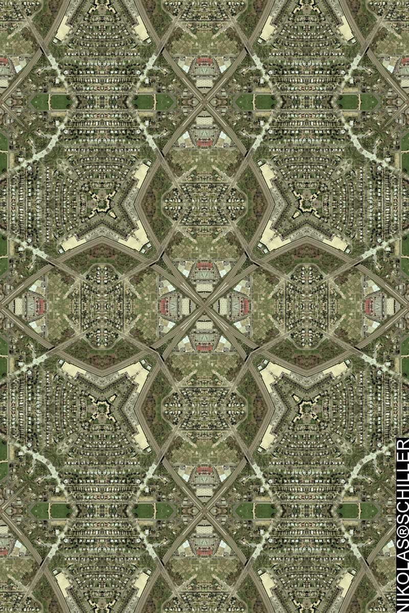
So I never got around to making a map of downtown Birmingham, Alabama, but I still plan on doing so. Instead I decided to seek out a somewhat new place and try out a new style. For years I have been reticent about making a map that it not composed of an urban area. I always thought that it was the buildings and the streets that gave each map its intrinsic uniqueness, but with this map, I have branched out, tried something new, and am pleasantly surprised with the results.

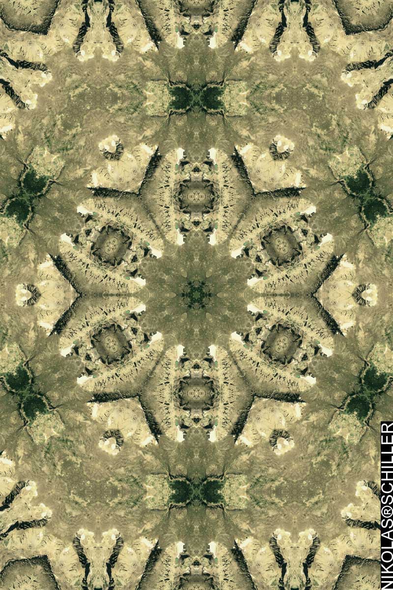
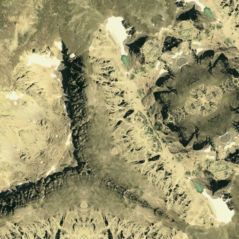
Years ago I posted a topographic map of Rocky Mountain National Park featuring the first mountains I ever climbed as a child. It was also the first topographic map posted this to this blog, and to continue this line of thought, I was delighted to find that the imagery was available to create the first map of its type. Instead of the aerial photography being too dull to be worthy of a map, I found it interesting that the shadows created by the ridge line added some aerial chiaroscuro. Moreover, upon closer examination, due to the spatial resolution of the source aerial photography, you can actually make out the trails crisscrossing through the forest. While they don’t appear as well as a highway or skyscraper, the trails and shadows help make create a map that I am happy to publish here.

Another striking feature of the imagery is the color tone of the tarn at the base of Andrews Glacier. This blue/green lake adds a unique color contrast to the somewhat monotone yellow hue of the rocky terrain. I do, however, wish there was a bit more color contrast between the east side of the continental divide and the west side of the continental divide that I’ve seen when I’ve stood atop these mountains. I also kinda wish, for once, that the aerial photography wasn’t taken from nadir, rather I wish it was taken at an oblique angle because we’d be able to see more elevation contrast between the various mountain peaks. However, since I have hiked these mountains, I know the continental divide shown in this aerial photography traverses north and south and the shadows are only formed from the ridges extending west from the continental divide. This makes it slightly easier to differentiate where the ridges are, but not where the peaks are. Anyways, I’ve decided to sample a portion of this imagery and will make another iteration of this map shortly.

View the Google Map of the Front Range in Rocky Mountain National Park in Colorado. Curiously, the imagery used on Google Maps shows the area during the winter time and covered in snow.

: detail of Andrews Glacier :

View the rest of the map details:

+ MORE


Malfunction Junction Offset
|| 6/16/2009 || 1:35 pm || Comments Off on Malfunction Junction Offset || ||

: rendered at 18,000 X 12,000 :
Malfunction Junction Offset by Nikolas R. Schiller

The other week I downloaded the aerial photography of downtown Birmingham, Alabama to make some maps for a friend of mine. Upon closer inspection of the geography, I found that there was a nicely formed highway interchange close to the downtown area that happened to be colloquially named “Malfunction Junction.” While other cities can also claim in having their own Malfunction Junction, this highway interchange is the first one I’ve read about.

When I started working on this map I intended to render a couple versions and recursively sample them to created a fractal map, but I wasn’t happy with the results, so I decided to go in a completely direction. This map did end up using previously sampled imagery, but it does not conform to that regular quilt projection format of a centralized kaleidoscope. Also, this map is not unlike some of my previous maps, like White House Sunrise or Minneapolis Sunset, however, I chose to name it differently based on the position of the kaleidoscope’s focal point, which is offset in the upper left hand corner. I spent a lot of time adjusting this location and as you can see in the last detail below, I was a few pixels off. Up next I’m probably going to work on the downtown area of Birmingham, but I’m really itching to start mapping Europe.


View the Google Map of Malfunction Junction in Birmingham, Alabama

: detail :

View the rest of the map details:

+ MORE


The Daily Render By
A Digital Scrapbook for the Past, Present, and Future.

©2004-2026 Nikolas R. Schiller - Former Colonist of the District of Columbia - Privacy Policy - Fair Use - RSS - Contact


::LAST 51 POSTS::

Fair Use


53 queries. 3.093 seconds.
Powered by WordPress

Photo by Charlie McCormick
Hello! Thanks for stopping by! My name is Nikolas Schiller. I am an American citizen currently living in New York City and working remotely to support structural change in Washington, DC.

This blog is my online repository of what I have created or found online since May of 2004. I've been on hiatus since 2018 but plan on contributing more content in the not so distant future.

If you have any questions or comments, please contact:

If you would like to use content found here, please consult my Fair Use page.

::THE QUILT PROJECTION::

Square
Square

Diamond
diamond

Hexagon
hexagon

Octagon
octagon

Dodecagon
Dodecagon

Beyond
beyond

::OTHER PROJECTIONS::

The Lenz Project
Lenz

Mandala Project
Mandala

The Star Series


Abstract Series
abstract

Memory Series
Memory

Mother Earth Series
Mother Earth

Misc Renderings
Misc

::POPULAR MAPS::

- The Los Angeles Interchanges Series
- The Lost Series
- Terra Fermi
- Antique Map Mashups
- Google StreetView I.E.D.
- LOLmaps
- The Inaugural Map
- The Shanghai Map
- Ball of Destruction
- The Lenz Project - Maps at the Library of Congress
- Winner of the Everywhere Man Award

::MONTHLY ARCHIVES::


@NikolasSchiller

::LOCATIONS & CATEGORIES::

  • 2004 Elections (2)
  • 2008 Elections (35)
  • 2014 Elections (4)
  • 2016 Elections (2)
  • ACLU (3)
  • Activism (287)
  • Adbusters (13)
  • Advertisements (33)
  • aerial photography (19)
  • Analysis (31)
  • Animals (30)
  • animated gif (7)
  • Animation (25)
  • Antique (104)
  • Apple (1)
  • Arabic (17)
  • Architectural Archeology (9)
  • Artomatic (25)
  • Astronomy (15)
  • Astrophotography (9)
  • Audio (2)
  • Awards (3)
  • Backpacking (2)
  • banner graphics (5)
  • Beat Google to the Map (56)
  • bicycle (23)
  • Birds-Eye View (5)
  • Blaeu (10)
  • Book Covers (7)
  • Bridge (10)
  • Building (15)
  • calendar (28)
  • calligraphy (6)
  • Capital (61)
  • Cars (18)
  • Cartography (74)
  • Cartoon (9)
  • Celestial (31)
  • Censorship (32)
  • Chinese (7)
  • Chronicling America (34)
  • Classroom (5)
  • Clothing (12)
  • Commentary (76)
  • Commissioned (27)
  • Credit Cards (3)
  • Crime (12)
  • Cyrillic Alphabet (1)
  • DAILY LINKS (30)
  • Dance (2)
  • DC History (93)
  • Design (102)
  • Digital Scrap (5)
  • Election (11)
  • ESA (3)
  • Facebook (19)
  • Fantasy (3)
  • Fashion (23)
  • Fast Food (2)
  • FBI (7)
  • Flag (15)
  • flickr (4)
  • Found Map (56)
  • French (9)
  • Gallery (54)
  • Gardening (25)
  • General (256)
  • George Bush (12)
  • GIS (69)
  • GMO Labeling (4)
  • Google (31)
  • Google AdSense (4)
  • Google AdWords (3)
  • Google Earth (28)
  • Google Maps (47)
  • Google Reader (4)
  • Google Streetview (8)
  • GPS (7)
  • Graffiti (5)
  • Greek (4)
  • Green (72)
  • Green Party (18)
  • Healthcare (15)
  • Highway (35)
  • Hiking (2)
  • Hipster (2)
  • history (151)
  • Holidays (10)
  • House Party (2)
  • Hubble Telescope (2)
  • Humor (88)
  • In The News (88)
  • Insects (2)
  • Interactive (74)
  • Interiors (4)
  • IP Trace (28)
  • Latin (22)
  • Law (15)
  • Lecture (11)
  • Legislation (19)
  • Library (21)
  • Library of Congress (66)
  • Location (1,018)
  • LOLMaps (3)
  • Mass Transit (6)
  • Memorandum (2)
  • meta-data (32)
  • Mobile Phone Applications (1)
  • Movie (3)
  • MrSID (4)
  • MSN (5)
  • Museum (5)
  • Music (48)
  • MySpace (6)
  • NASA (10)
  • National Archives (3)
  • News (182)
  • Obituary (2)
  • Oil (4)
  • Ornithology (4)
  • orthophotography (4)
  • OSCE (16)
  • Photography (134)
  • Poetry (18)
  • Portuguese (1)
  • postmodern (8)
  • QR code (9)
  • QTVR (4)
  • Radio (3)
  • Renderings (675)
  • RSS (3)
  • Seasons (12)
  • Sold (40)
  • Spanish (7)
  • Speech (5)
  • Sports (1)
  • Stadium (40)
  • statehood (94)
  • Statistics (2)
  • Stellarium (4)
  • Stereogram (1)
  • Street (21)
  • Street Art (10)
  • Submissions (5)
  • Tattoo (2)
  • Testimony (2)
  • time-lapse (19)
  • Torture (3)
  • Transportation (6)
  • TV (23)
  • Twitter (5)
  • University (41)
  • Update (24)
  • Vegetarianism (2)
  • Video (49)
  • Vimeo (18)
  • visualization (36)
  • Washington Critic (2)
  • Weather (19)
  • Web Crawler (9)
  • Wikipedia (14)
  • Wordpress (4)
  • Wordpress Upgrade (2)
  • World Wind (3)
  • Yahoo (6)
  • YouTube (113)
  • Zodiac (23)


  • thank you,
    come again!