The Daily Render

by

A Digital Scrapbook for the Past, Present, and Future

| FRONT PAGE | GEOSPATIAL ART | DC HISTORY / TIMELINE | NEWS | COLONIST | FOUND MAPS | FRACTALS |
| PHOTOGRAPHY | ANTIQUE | DESIGN | VIDEO | | CONTACT |

Harvard Quilt #3
|| 2/25/2009 || 1:42 pm || Comments Off on Harvard Quilt #3 || ||

: rendered at 18,000 X 12,000 :
Harvard Quilt Number 3 by Nikolas R. Schiller

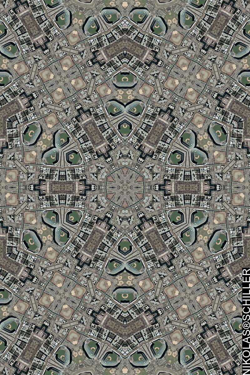
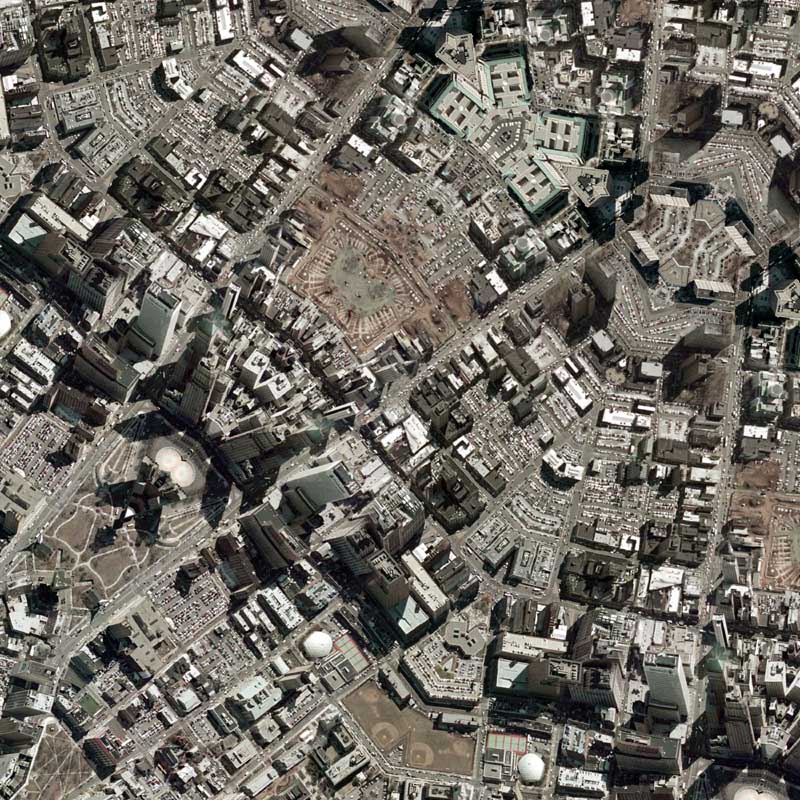
The other day I decided to snoop around on some of my old hard drives and discovered that I had quite a bit of imagery that I never used to create a map. Yesterday I decided to use some of this imagery to make today’s map. It features .3 meter per pixel imagery that was taken in 2002 of the area around Harvard University.

What is interesting about this imagery is that its really not .3 meters per pixel, but closer to .6 meters per pixel. I found this out when I was post-processing this map and discovered that when the imagery is viewed at its full resolution it becomes quite blurry. At first I thought that I had screwed up and over-projected the map, but when I reopened the source imagery I discovered that it was blurry to begin with. Had I known this, I would have only rendered the map at 9,000 x 6,000 (one half the current size) because this downsampling would make the map less blurry.

Anyways, I haven’t been as active on the mapping front because I’ve made just about every major city in America. I still intend on publishing an atlas featuring all of these maps, but I have yet to find an interested publisher and am wary about going down the self-publishing route. I would, however, love to start mapping cities in Europe. Please contact me if you can obtain public domain imagery of any European city.

View the Google Map of Harvard University in Cambridge, Massachusetts

: detail :

Do you see the heart within a heart?

View the rest of the map details:

+ MORE


Georgetown Quilt #5
|| 1/14/2009 || 11:07 pm || Comments Off on Georgetown Quilt #5 || ||

: rendered at 9,000 X 6,000 :
Georgetown Quilt Number 5 by Nikolas R. Schiller

Its been awhile since I’ve made a map, so I decided to revisit Georgetown. When making this map, I tried to center the focus on the intersection of M Street & Wisconsin Ave. I was able to do this more easily because I started with a smaller piece of aerial photography than I normally work with.

View the Google Map of the Georgetown neighborhood in Washington, DC

: detail :

View the rest of the details:

+ MORE


Saint Louis Art Museum Quilt
|| 12/23/2008 || 12:12 am || Comments Off on Saint Louis Art Museum Quilt || ||

: rendered at 18,000 X 12,000 :
Saint Louis Art Museum Quilt by Nikolas R. Schiller

I recently read about the proposed expansion of the Saint Louis Art Museum and was reminded of all the hours I spent there when I was a kid. From school field trips to miscellaneous enrichment visits with friends & family friends, the museum was an integral part of my upbringing. My mom even has a VHS tape of me that was recorded there when I was 8 years old (1988). If my memory serves me right, I was enthusiastically talking about the notion of living in Egypt two thousand years ago, being a pharaoh, and the pyramids. Its been nearly 5 years since I set foot inside the museum and I wonder how much different it will look with the new wing? Probably not as awesome as it looked during the 1904 World’s Fair when it was the Palace of the Fine Arts, but I digress. Times do change and when I visit family during the holidays I’m going to inquire about the location of that VHS tape. I’m also going to look into my digital photo archives because I believe I took some nighttime time-lapse photos of the exterior of the museum in 2002. They’ll be a good follow-up entry.

View the Google Map of the Saint Louis Art Museum in Saint Louis, Missouri

: detail :

View the rest of the details:

+ MORE


Commission: Yankee Stadium Quilt
|| 12/19/2008 || 1:51 pm || Comments Off on Commission: Yankee Stadium Quilt || ||

: rendered at 9,000 X 6,000 :
Yankee Stadium by Nikolas R. Schiller

At the beginning of the week I received an inquiry about making this map. It’s intended to be a gift for the client’s friend who’s a big Yankees fan. I was unsure if I’d be able to obtain the newest imagery featuring the new Yankee stadium, but since the client felt the friend had spent more time in the old stadium, the newest of the imagery was not an issue. I went with .5 meters per pixel imagery from April, 2006. There was a second set of imagery of the area at lower spatial resolution, but I liked the coloring on this imagery better and went with it. This is my first map of the Bronx borough of New York City and for 2009 I am planning on mapping the rest of the boroughs.

Like my previous commission I was able to modify the source aerial photography so that the nearby outdoor track has been converted into a heart. I debated on modifing the coloration so that the pinkness of the heart (below) would be more pronounced, but I opted to follow my current style of non-modification. Yet this inclusion of the heart motif is something that I find to be an unique addition to my current map design. I am adjusting the imagery to not only create a geometrically perfect design, but literally adding a bit of love to it. An aerial landscape design of love, so to speak.

There is also a sense of transition in this map. By the varying degree of translational symmetry placed upon the the actual stadium, there appears to be an architectural metamorphosis taking place. Where the old stadium is becoming a new stadium. And some day in the future, when it’s time that I make the next map of Yankee Stadium, with newer contemporary imagery, it will be a new stadium. But will the heart (track) still be there in the future? Will development change the love of the geography? I don’t think so. Yet in making this map for the client, I’ve captured the love between two people (and probably thousands of others) that will never change.

Unlike my previous commissioned map, which was printed at 32″x48″ on stretched canvas, this Hexagon Quilt Project map will be printed a bit smaller at 10″x16″ on Hahnemuhle Fine Art Pearl paper. If you are interested in obtaining a custom map, please don’t hesitate to contact me.

View the Google Map of Yankee Stadium in the Bronx

: detail :

View the rest of the details:

+ MORE


Newark Quilt #2
|| 12/13/2008 || 10:04 pm || Comments Off on Newark Quilt #2 || ||

: rendered at 18,000 X 12,000 :
Newark Quilt #2 by Nikolas R. Schiller

Using this portion of Newark Quilt, I was able to constructive this Hexagon Quilt Projection derivative map. If you look closely there is a nice hexagram in the center of the map. I’d like to make a map of Trenton, New Jersey next.

View the Google Map of downtown Newark, New Jersey

: detail :

View the rest of the details:

+ MORE


Newark Quilt
|| 12/12/2008 || 11:43 pm || Comments Off on Newark Quilt || ||

: rendered at 18,000 X 12,000 :
Newark Quilt by Nikolas R. Schiller

Would you believe that this is my first map of the Garden State? It is. After hundreds of maps, I have finally gotten around to making a map of New Jersey. Originally the delay was based on the availability of color imagery due to the fact that I could only obtain false-color composite imagery of New Jersey. While it looks nice, it is not within the color parameters I’ve chosen to work with. If you look around this website you won’t see any quilt projection maps using this type of coloring. While I have modified the colors of the source aerial photography before, I have not started with false-color imagery and then made a map.

The imagery I was able to obtain and use for this Dodecagon Quilt Projection map is, ummm, to say it nicely, pretty much crap. According to the metadata, this .5 meter aerial photography was taken in March of 2006, processed in June of 2006, and released to the public on June 26th, 2007. Instead of using a digital camera, this imagery was taken with an analog film camera, printed out, scanned, and finally digitally altered for correctness. The result is a very grainy resolution when looked at up close and is comparable to the poor-quality Los Angeles imagery I worked with last year.

The imagery also suffers from the fact that it wasn’t taken completely at nadir. This means that you can see a mishmash of perspectives, where buildings literally run into each other because the angle at which the photograph was taken wasn’t completely overhead (nadir). For example, in the detail below you can actually read the lettering of the Prudential building due to the obliqueness of the original aerial photograph.

Anyways, now I only have to complete a map of somewhere in Vermont and I’ll have a made a map of a city in every state in the United States! I think its time to remove the dust from my last book proposal….

View the Google Map of downtown Newark, New Jersey

: detail :

View the rest of the details:

+ MORE


Eye 670 – A perspective of Interstate 670 in downtown Kansas City
|| 12/10/2008 || 3:04 pm || Comments Off on Eye 670 – A perspective of Interstate 670 in downtown Kansas City || ||

: rendered at 9,000 X 6,000 :
Eye 670 by Nikolas R. Schiller

Using this portion of Kansas City Quilt #2, I created this derivative map of downtown Kansas City, Missouri. This map is a unique map because it features aspects of the Lenz Projection and the Quilt Projection combined to create what looks like a human eye. By combing what it looks like with the location, I-670, the name of this map becomes a play on words.

View the Google Map of downtown Kansas City, Missouri

: detail :

View the rest of the details:

+ MORE


Kansas City Quilt #2
|| 12/9/2008 || 2:42 pm || Comments Off on Kansas City Quilt #2 || ||

: rendered at 18,000 X 12,000 :
Kansas City Quilt #2 by Nikolas R. Schiller

Using this portion of Kansas City Quilt, I created this derivative map of downtown Kansas City, Missouri. When making this map I tried a few different variations but settled on a Diamond Quilt Projection map.

View the Google Map of downtown Kansas City, Missouri

: detail :

View the rest of the details:

+ MORE


Kansas City Quilt
|| 12/8/2008 || 2:19 pm || Comments Off on Kansas City Quilt || ||

: rendered at 18,000 X 12,000 :
Kansas City Quilt by Nikolas R. Schiller

It’s been over a month since I’ve made a map and to knock the dust off of this website I’ve decided to make a map of city that I’ve never sampled before. For over two years there was a licensing issue that prevented the imagery used in this map from being placed into the public domain. I don’t know when it was finally released, but I’m happy they did. This map features the downtown area of the Missouri side of Kansas City and when I was tessellating the source aerial photography I made sure to include something I remembered from when I was a kid. When we’d drive to Colorado from Missouri, we’d drive through downtown Kansas City and I always thought it was cool that there was a portion that created a tunnel that cars drove under. While I didn’t know it at the time, this building is the Bartle Hall Convention Center and I placed it at the exact center of this Octagon Quilt Projection map.

View the Google Map of downtown Kansas City, Missouri

: detail :

View the rest of the details:

+ MORE


The Grand Juxtaposition
|| 11/15/2008 || 6:38 pm || Comments Off on The Grand Juxtaposition || ||

Back in March of this year, I mentioned that I was in the process of making another interactive environment for the Lost Series. The concept behind “The Grand Juxtaposition” is to put two unrelated images originally featured in a previous blog entry together on the same page. This is achieved by giving the viewer two random pictures from somewhere on this website upon each loading of the web page. In the background of the page, the viewer is shown a random image from my posters folder (which contains over 2,000 different images) and in the foreground the viewer is being shown an image from my images folder (which contains over 500 different images). Upon clicking on the image in the foreground, the next page that loads will be the inverse, where a graphic from the posters folder is placed in the foreground and the a graphic from the image folder is used in the background. Generally speaking, most entries on this website feature images from either one of the two folders and by placing them together on one page, I’ve created a grand juxtaposition to showcase this website’s visually diverse content.


Related Interactive Entries:

+ MORE


The Daily Render By
A Digital Scrapbook for the Past, Present, and Future.

©2004-2026 Nikolas R. Schiller - Former Colonist of the District of Columbia - Privacy Policy - Fair Use - RSS - Contact


::LAST 51 POSTS::

Fair Use


53 queries. 3.410 seconds.
Powered by WordPress

Photo by Charlie McCormick
Hello! Thanks for stopping by! My name is Nikolas Schiller. I am an American citizen currently living in New York City and working remotely to support structural change in Washington, DC.

This blog is my online repository of what I have created or found online since May of 2004. I've been on hiatus since 2018 but plan on contributing more content in the not so distant future.

If you have any questions or comments, please contact:

If you would like to use content found here, please consult my Fair Use page.

::THE QUILT PROJECTION::

Square
Square

Diamond
diamond

Hexagon
hexagon

Octagon
octagon

Dodecagon
Dodecagon

Beyond
beyond

::OTHER PROJECTIONS::

The Lenz Project
Lenz

Mandala Project
Mandala

The Star Series


Abstract Series
abstract

Memory Series
Memory

Mother Earth Series
Mother Earth

Misc Renderings
Misc

::POPULAR MAPS::

- The Los Angeles Interchanges Series
- The Lost Series
- Terra Fermi
- Antique Map Mashups
- Google StreetView I.E.D.
- LOLmaps
- The Inaugural Map
- The Shanghai Map
- Ball of Destruction
- The Lenz Project - Maps at the Library of Congress
- Winner of the Everywhere Man Award

::MONTHLY ARCHIVES::


@NikolasSchiller

::LOCATIONS & CATEGORIES::

  • 2004 Elections (2)
  • 2008 Elections (35)
  • 2014 Elections (4)
  • 2016 Elections (2)
  • ACLU (3)
  • Activism (287)
  • Adbusters (13)
  • Advertisements (33)
  • aerial photography (19)
  • Analysis (31)
  • Animals (30)
  • animated gif (7)
  • Animation (25)
  • Antique (104)
  • Apple (1)
  • Arabic (17)
  • Architectural Archeology (9)
  • Artomatic (25)
  • Astronomy (15)
  • Astrophotography (9)
  • Audio (2)
  • Awards (3)
  • Backpacking (2)
  • banner graphics (5)
  • Beat Google to the Map (56)
  • bicycle (23)
  • Birds-Eye View (5)
  • Blaeu (10)
  • Book Covers (7)
  • Bridge (10)
  • Building (15)
  • calendar (28)
  • calligraphy (6)
  • Capital (61)
  • Cars (18)
  • Cartography (74)
  • Cartoon (9)
  • Celestial (31)
  • Censorship (32)
  • Chinese (7)
  • Chronicling America (34)
  • Classroom (5)
  • Clothing (12)
  • Commentary (76)
  • Commissioned (27)
  • Credit Cards (3)
  • Crime (12)
  • Cyrillic Alphabet (1)
  • DAILY LINKS (30)
  • Dance (2)
  • DC History (93)
  • Design (102)
  • Digital Scrap (5)
  • Election (11)
  • ESA (3)
  • Facebook (19)
  • Fantasy (3)
  • Fashion (23)
  • Fast Food (2)
  • FBI (7)
  • Flag (15)
  • flickr (4)
  • Found Map (56)
  • French (9)
  • Gallery (54)
  • Gardening (25)
  • General (256)
  • George Bush (12)
  • GIS (69)
  • GMO Labeling (4)
  • Google (31)
  • Google AdSense (4)
  • Google AdWords (3)
  • Google Earth (28)
  • Google Maps (47)
  • Google Reader (4)
  • Google Streetview (8)
  • GPS (7)
  • Graffiti (5)
  • Greek (4)
  • Green (72)
  • Green Party (18)
  • Healthcare (15)
  • Highway (35)
  • Hiking (2)
  • Hipster (2)
  • history (151)
  • Holidays (10)
  • House Party (2)
  • Hubble Telescope (2)
  • Humor (88)
  • In The News (88)
  • Insects (2)
  • Interactive (74)
  • Interiors (4)
  • IP Trace (28)
  • Latin (22)
  • Law (15)
  • Lecture (11)
  • Legislation (19)
  • Library (21)
  • Library of Congress (66)
  • Location (1,018)
  • LOLMaps (3)
  • Mass Transit (6)
  • Memorandum (2)
  • meta-data (32)
  • Mobile Phone Applications (1)
  • Movie (3)
  • MrSID (4)
  • MSN (5)
  • Museum (5)
  • Music (48)
  • MySpace (6)
  • NASA (10)
  • National Archives (3)
  • News (182)
  • Obituary (2)
  • Oil (4)
  • Ornithology (4)
  • orthophotography (4)
  • OSCE (16)
  • Photography (134)
  • Poetry (18)
  • Portuguese (1)
  • postmodern (8)
  • QR code (9)
  • QTVR (4)
  • Radio (3)
  • Renderings (675)
  • RSS (3)
  • Seasons (12)
  • Sold (40)
  • Spanish (7)
  • Speech (5)
  • Sports (1)
  • Stadium (40)
  • statehood (94)
  • Statistics (2)
  • Stellarium (4)
  • Stereogram (1)
  • Street (21)
  • Street Art (10)
  • Submissions (5)
  • Tattoo (2)
  • Testimony (2)
  • time-lapse (19)
  • Torture (3)
  • Transportation (6)
  • TV (23)
  • Twitter (5)
  • University (41)
  • Update (24)
  • Vegetarianism (2)
  • Video (49)
  • Vimeo (18)
  • visualization (36)
  • Washington Critic (2)
  • Weather (19)
  • Web Crawler (9)
  • Wikipedia (14)
  • Wordpress (4)
  • Wordpress Upgrade (2)
  • World Wind (3)
  • Yahoo (6)
  • YouTube (113)
  • Zodiac (23)


  • thank you,
    come again!