
About a month ago I made the first version of the map using the Western Hemisphere. At the time I didn’t even think about making a secondary map for the Eastern Hemisphere.
+ MORE
| FRONT PAGE |
GEOSPATIAL ART |
DC HISTORY / TIMELINE |
NEWS |
COLONIST |
FOUND MAPS |
FRACTALS |
|
PHOTOGRAPHY |
ANTIQUE |
DESIGN |
VIDEO |
|
CONTACT |
An Updated Astrological Calendar from 1544 – Eastern Hemisphere
|| 8/10/2007 || 10:31 pm || Comments Off on An Updated Astrological Calendar from 1544 – Eastern Hemisphere || ||
About a month ago I made the first version of the map using the Western Hemisphere. At the time I didn’t even think about making a secondary map for the Eastern Hemisphere.
+ MORE
An Updated Astrological Calendar from 1544 – Western Hemisphere
|| 7/8/2007 || 12:40 pm || Comments Off on An Updated Astrological Calendar from 1544 – Western Hemisphere || ||

This morning I was looking through the digital collection of maps at the Geography & Mapping Division of the Library of Congress and found this astrological calendar on the 4th page of a Battista Agnese atlas published in 1544 (citation after the fold).
The calendar is built on two concentric circles; the inner circle depicts the Gregorian calendar and the outer circle shows the Zodiac calendar. According to the Wikipedia entry, the Gregorian calendar was not adopted for another 38 years after the atlas was published.
In the original drawing (below) the center of the astrological calendar was a very tiny earth. I believe it was drawn to show the earth’s celestial relationship to the seasons, and while the scale is off, the coloring is surprisingly accurate. By adding the satellite image over top of the original I gave it an update 463 years in the making.
View the Interactive & Original version:
+ MORE
A New And Accurate Map of the World by John Speed [2007 Remix]
|| 6/25/2007 || 6:46 pm || Comments Off on A New And Accurate Map of the World by John Speed [2007 Remix] || ||
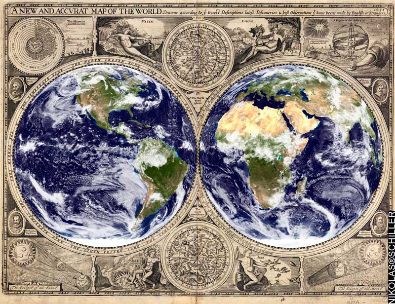
In honor of the cartographic activities over the last three years, today I made what I feel to be one of my best historic map mashups yet. Using a map by John Speed (published in London in 1651) obtained from the Yale University Library, I overlaid two NASA Blue Marble satellite images over the known world. Aside from that, I didn’t do anything else to this map (like cryptic seventeenth century typography) except to add my name in the lower left hand corner.
Text from the top:
“A NEW AND ACCURATE MAP OF THE WORLD – Drawn according to the truest descriptions, latest discoveries, & best observations that have been made by English or Strangers. 1651”
The original engraving includes:
• the 4 basic elements: Earth, Wind, Water, and Fire
• the constellations for both the southern & northern hemisphere
• portraits 4 of the most important explorers up until 1651
• the science behind eclipses
The original map was made in 1651, the NASA Blue Marble images were released in 2002, and the two combined today; a 356 year enrichment.
If I want to sell this map I’ll need to first obtain the copyright from the Yale University Library, which is $500! Bleh. It’s too bad that the Library of Congress does not have this map available.
+ MORE
©2004-2026 Nikolas R. Schiller - Former Colonist of the District of Columbia - Privacy Policy - Fair Use - RSS - Contact
::LAST 51 POSTS::
52 queries. 3.231 seconds.
Powered by WordPress


::THE QUILT PROJECTION::
Square |
Diamond |
Hexagon |
Octagon |
Dodecagon |
Beyond |
::OTHER PROJECTIONS::
The Lenz Project |
Mandala Project |
The Star Series |
Abstract Series |
Memory Series
|
Mother Earth Series
|
|
Misc Renderings
 |
::POPULAR MAPS::
- The Los Angeles Interchanges Series::MONTHLY ARCHIVES::
::LOCATIONS & CATEGORIES::