The Daily Render

by

A Digital Scrapbook for the Past, Present, and Future

| FRONT PAGE | GEOSPATIAL ART | DC HISTORY / TIMELINE | NEWS | COLONIST | FOUND MAPS | FRACTALS |
| PHOTOGRAPHY | ANTIQUE | DESIGN | VIDEO | | CONTACT |

Postmodern Cartography: You Are Probably Not Here
|| 8/8/2009 || 2:56 pm || 3 Comments Rendered || ||

You Are Probably Not Here with pushpins

Just click!

You’ve probably seen a map sometime in your lifetime that proclaims YOU ARE HERE. Well what if you are looking at a random location? You could actually be there, but you are probably not. I first came up with this postmodern cartographic concept back in December of 2007 when I made the first graphic. Yesterday I decided to expand the concept by adding new graphics and making a webpage dedicated to the concept. It currently features only 8 different foreground graphics that are randomly displayed over two folders of map ‘zoom-ins’ (146 close up & 136 far away) originally used in “American Stereography #3.” I hope to add more foreground graphics over time and I would also like to update the background image folders with newer imagery because the page currently shows only maps that I made in 2006.

Total number of visual combinations: 2256 = (146 X 8) + (136 X 8)

Just click click click to cycle through the images


Related Lost Series Entries:

+ MORE


Note to the cartographers at the New York Times: the Red Line goes into Maryland
|| 7/11/2009 || 7:00 pm || + Render A Comment || ||

I know this a bit late, but I was looking over the coverage of the DC Metro train collision last month on the websites of the Washington Post (below) and the New York Times (above) and noticed one glaring error in the New York Times map. The Red Line does not start and end at the borders of the District of Columbia, rather it extends far into the state of Maryland. Maybe the New York Times can issue a cartographic correction?

I guess you could say this is a good example of when the local newspaper gets it right…


Related Found Maps:

+ MORE


The Craig Retroazimuthal Projection aka the Mecca Projection
|| 4/21/2009 || 11:45 am || Comments Off on The Craig Retroazimuthal Projection aka the Mecca Projection || ||

The Craig retroazimuthal map projection was created by James Ireland Craig in 1909. It is a cylindrical projection preserving the direction from any place to another predetermined place, while avoiding some of the bizarre distortion of the Hammer retroazimuthal projection. It is sometimes known as the Mecca projection because Craig, who had worked in Egypt as a cartographer, created it to help Muslims find their Qibla. Check out the mathematical calculation used to create the map on Wikipedia.

I think it would be neat to use this cartographic projection technique to create a map that uses Washington, DC as the center.


Related Mecca Entries:

+ MORE


World Wildlife Fund’s Zoomorphic Fantasy Maps
|| 3/27/2009 || 1:25 pm || 1 Comment Rendered || ||

Click to view full-size image

I came across these zoomorphic fantasy maps a few weeks ago and smiled. They brought back fond memories of when I was in second grade and used to draw large futuristic cities during my free time in school. I prefer to think that those sketches were the visual result of the influence that Sim City had on me back then.

These black & white bird’s eye view sketches show an elephant (above), rhinoceros (below), and sea turtle (below) all include the text of the campaign: “Our life at the cost of theirs?” The aim of this campaign is to frame the encroachment of urban life within the scope of contemporary degradation of the natural ecosystems these animals live in. By drawing these imaginative urban areas within the outlines of the endangered animals, the artists present a poignant perspective of whether our urban societies can sustain their current growth without damaging the animal’s fragile habitat.


Since the original images are larger than the formatting I use here, I have shrunk them down for layout purposes. By clicking on the images, you can see them in full-size.


CITATION
Advertising Agency: Ogilvy & Mather, Mumbai, India
Executive Creative Director: Piyush Pandey
Creative Director: Sumanto Chattopadhyay
Art Directors: Mayur varma, Mandar Wairkar
Illustrators: Swapnil Nilkanth, Nishikant Palande
Copywriters: Sumanto Chattopadhyay, Karn Singh, Mandar Wairkar
[VIA Ads of the World]


View the other fantasy maps:

+ MORE


The Peters Projection advocated on the West Wing television show
|| 2/20/2009 || 1:35 am || Comments Off on The Peters Projection advocated on the West Wing television show || ||

NBC’s The West Wing – Why are we changing maps?? – From season 2 – Episode 16
A fictional group called the “Organization of Cartographers for Social Equality,” pitches President Bartlet’s staff to “aggressively support” legislation mandating every public school in America teach geography using the Peters Projection map.


Read more about the Gall-Peters Projection on Wikipedia. Or check out this trailer. [VIA Press Release from 2001]


Newark Quilt #2
|| 12/13/2008 || 10:04 pm || Comments Off on Newark Quilt #2 || ||

: rendered at 18,000 X 12,000 :
Newark Quilt #2 by Nikolas R. Schiller

Using this portion of Newark Quilt, I was able to constructive this Hexagon Quilt Projection derivative map. If you look closely there is a nice hexagram in the center of the map. I’d like to make a map of Trenton, New Jersey next.

View the Google Map of downtown Newark, New Jersey

: detail :

View the rest of the details:

+ MORE


Newark Quilt
|| 12/12/2008 || 11:43 pm || Comments Off on Newark Quilt || ||

: rendered at 18,000 X 12,000 :
Newark Quilt by Nikolas R. Schiller

Would you believe that this is my first map of the Garden State? It is. After hundreds of maps, I have finally gotten around to making a map of New Jersey. Originally the delay was based on the availability of color imagery due to the fact that I could only obtain false-color composite imagery of New Jersey. While it looks nice, it is not within the color parameters I’ve chosen to work with. If you look around this website you won’t see any quilt projection maps using this type of coloring. While I have modified the colors of the source aerial photography before, I have not started with false-color imagery and then made a map.

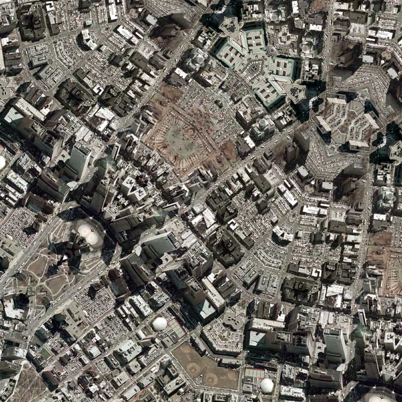
The imagery I was able to obtain and use for this Dodecagon Quilt Projection map is, ummm, to say it nicely, pretty much crap. According to the metadata, this .5 meter aerial photography was taken in March of 2006, processed in June of 2006, and released to the public on June 26th, 2007. Instead of using a digital camera, this imagery was taken with an analog film camera, printed out, scanned, and finally digitally altered for correctness. The result is a very grainy resolution when looked at up close and is comparable to the poor-quality Los Angeles imagery I worked with last year.

The imagery also suffers from the fact that it wasn’t taken completely at nadir. This means that you can see a mishmash of perspectives, where buildings literally run into each other because the angle at which the photograph was taken wasn’t completely overhead (nadir). For example, in the detail below you can actually read the lettering of the Prudential building due to the obliqueness of the original aerial photograph.

Anyways, now I only have to complete a map of somewhere in Vermont and I’ll have a made a map of a city in every state in the United States! I think its time to remove the dust from my last book proposal….

View the Google Map of downtown Newark, New Jersey

: detail :

View the rest of the details:

+ MORE


Eye 670 – A perspective of Interstate 670 in downtown Kansas City
|| 12/10/2008 || 3:04 pm || Comments Off on Eye 670 – A perspective of Interstate 670 in downtown Kansas City || ||

: rendered at 9,000 X 6,000 :
Eye 670 by Nikolas R. Schiller

Using this portion of Kansas City Quilt #2, I created this derivative map of downtown Kansas City, Missouri. This map is a unique map because it features aspects of the Lenz Projection and the Quilt Projection combined to create what looks like a human eye. By combing what it looks like with the location, I-670, the name of this map becomes a play on words.

View the Google Map of downtown Kansas City, Missouri

: detail :

View the rest of the details:

+ MORE


Kansas City Quilt #2
|| 12/9/2008 || 2:42 pm || Comments Off on Kansas City Quilt #2 || ||

: rendered at 18,000 X 12,000 :
Kansas City Quilt #2 by Nikolas R. Schiller

Using this portion of Kansas City Quilt, I created this derivative map of downtown Kansas City, Missouri. When making this map I tried a few different variations but settled on a Diamond Quilt Projection map.

View the Google Map of downtown Kansas City, Missouri

: detail :

View the rest of the details:

+ MORE


Kansas City Quilt
|| 12/8/2008 || 2:19 pm || Comments Off on Kansas City Quilt || ||

: rendered at 18,000 X 12,000 :
Kansas City Quilt by Nikolas R. Schiller

It’s been over a month since I’ve made a map and to knock the dust off of this website I’ve decided to make a map of city that I’ve never sampled before. For over two years there was a licensing issue that prevented the imagery used in this map from being placed into the public domain. I don’t know when it was finally released, but I’m happy they did. This map features the downtown area of the Missouri side of Kansas City and when I was tessellating the source aerial photography I made sure to include something I remembered from when I was a kid. When we’d drive to Colorado from Missouri, we’d drive through downtown Kansas City and I always thought it was cool that there was a portion that created a tunnel that cars drove under. While I didn’t know it at the time, this building is the Bartle Hall Convention Center and I placed it at the exact center of this Octagon Quilt Projection map.

View the Google Map of downtown Kansas City, Missouri

: detail :

View the rest of the details:

+ MORE


The Daily Render By
A Digital Scrapbook for the Past, Present, and Future.

©2004-2023 Nikolas R. Schiller - Colonist of the District of Columbia - Privacy Policy - Fair Use - RSS - Contact


::LAST 51 POSTS::

Fair Use


49 queries. 2.995 seconds.
Powered by WordPress

Photo by Charlie McCormick
Nikolas Schiller is a second-class American citizen living in America's last colony, Washington, DC. This blog is my on-line repository of what I have created or found on-line since May of 2004. If you have any questions or comments, please contact:

If you would like to use content found here, please consult my Fair Use page.

::THE QUILT PROJECTION::

Square
Square

Diamond
diamond

Hexagon
hexagon

Octagon
octagon

Dodecagon
Dodecagon

Beyond
beyond

::OTHER PROJECTIONS::

The Lenz Project
Lenz

Mandala Project
Mandala

The Star Series


Abstract Series
abstract

Memory Series
Memory

Mother Earth Series
Mother Earth

Misc Renderings
Misc

::POPULAR MAPS::

- The Los Angeles Interchanges Series
- The Lost Series
- Terra Fermi
- Antique Map Mashups
- Google StreetView I.E.D.
- LOLmaps
- The Inaugural Map
- The Shanghai Map
- Ball of Destruction
- The Lenz Project - Maps at the Library of Congress
- Winner of the Everywhere Man Award

::MONTHLY ARCHIVES::


::LOCATIONS & CATEGORIES::

  • 2004 Elections (2)
  • 2008 Elections (35)
  • 2014 Elections (4)
  • 2016 Elections (2)
  • ACLU (3)
  • Activism (287)
  • Adbusters (13)
  • Advertisements (33)
  • aerial photography (19)
  • Analysis (31)
  • Animals (30)
  • animated gif (7)
  • Animation (25)
  • Antique (104)
  • Apple (1)
  • Arabic (17)
  • Architectural Archeology (9)
  • Artomatic (25)
  • Astronomy (15)
  • Astrophotography (9)
  • Audio (2)
  • Awards (3)
  • Backpacking (2)
  • banner graphics (5)
  • Beat Google to the Map (56)
  • bicycle (23)
  • Birds-Eye View (5)
  • Blaeu (10)
  • Book Covers (7)
  • Bridge (10)
  • Building (15)
  • calendar (28)
  • calligraphy (6)
  • Capital (61)
  • Cars (18)
  • Cartography (74)
  • Cartoon (9)
  • Celestial (31)
  • Censorship (32)
  • Chinese (7)
  • Chronicling America (34)
  • Classroom (5)
  • Clothing (12)
  • Commentary (76)
  • Commissioned (27)
  • Credit Cards (3)
  • Crime (12)
  • Cyrillic Alphabet (1)
  • DAILY LINKS (30)
  • Dance (2)
  • DC History (93)
  • Design (102)
  • Digital Scrap (5)
  • Election (11)
  • ESA (3)
  • Facebook (19)
  • Fantasy (3)
  • Fashion (23)
  • Fast Food (2)
  • FBI (7)
  • Flag (15)
  • flickr (4)
  • Found Map (56)
  • French (9)
  • Gallery (54)
  • Gardening (25)
  • General (256)
  • George Bush (12)
  • GIS (69)
  • GMO Labeling (4)
  • Google (31)
  • Google AdSense (4)
  • Google AdWords (3)
  • Google Earth (28)
  • Google Maps (47)
  • Google Reader (4)
  • Google Streetview (8)
  • GPS (7)
  • Graffiti (5)
  • Greek (4)
  • Green (72)
  • Green Party (18)
  • Healthcare (15)
  • Highway (35)
  • Hiking (2)
  • Hipster (2)
  • history (151)
  • Holidays (10)
  • House Party (2)
  • Hubble Telescope (2)
  • Humor (88)
  • In The News (88)
  • Insects (2)
  • Interactive (74)
  • Interiors (4)
  • IP Trace (28)
  • Latin (22)
  • Law (15)
  • Lecture (11)
  • Legislation (19)
  • Library (21)
  • Library of Congress (66)
  • Location (1,018)
  • LOLMaps (3)
  • Mass Transit (6)
  • Memorandum (2)
  • meta-data (32)
  • Mobile Phone Applications (1)
  • Movie (3)
  • MrSID (4)
  • MSN (5)
  • Museum (5)
  • Music (48)
  • MySpace (6)
  • NASA (10)
  • National Archives (3)
  • News (182)
  • Obituary (2)
  • Oil (4)
  • Ornithology (4)
  • orthophotography (4)
  • OSCE (16)
  • Photography (134)
  • Poetry (18)
  • Portuguese (1)
  • postmodern (8)
  • QR code (9)
  • QTVR (4)
  • Radio (3)
  • Renderings (675)
  • RSS (3)
  • Seasons (12)
  • Sold (40)
  • Spanish (7)
  • Speech (5)
  • Sports (1)
  • Stadium (40)
  • statehood (94)
  • Statistics (2)
  • Stellarium (4)
  • Stereogram (1)
  • Street (21)
  • Street Art (10)
  • Submissions (5)
  • Tattoo (2)
  • Testimony (2)
  • time-lapse (19)
  • Torture (3)
  • Transportation (6)
  • TV (23)
  • Twitter (5)
  • University (41)
  • Update (24)
  • Vegetarianism (2)
  • Video (49)
  • Vimeo (18)
  • visualization (36)
  • Washington Critic (2)
  • Weather (19)
  • Web Crawler (9)
  • Wikipedia (14)
  • Wordpress (4)
  • Wordpress Upgrade (2)
  • World Wind (3)
  • Yahoo (6)
  • YouTube (113)
  • Zodiac (23)


  • thank you,
    come again!