Click the image below to download the .kmz file [7.8 mb] for Google Earth:

Using the center of 710 & 405 Quilt, which is in the Los Angeles Interchanges series, I constructed this beautiful globe.
+ MORE
| FRONT PAGE |
GEOSPATIAL ART |
DC HISTORY / TIMELINE |
NEWS |
COLONIST |
FOUND MAPS |
FRACTALS |
|
PHOTOGRAPHY |
ANTIQUE |
DESIGN |
VIDEO |
|
CONTACT |
Interchangable Earth
|| 8/15/2007 || 2:27 pm || Comments Off on Interchangable Earth || ||
Click the image below to download the .kmz file [7.8 mb] for Google Earth:
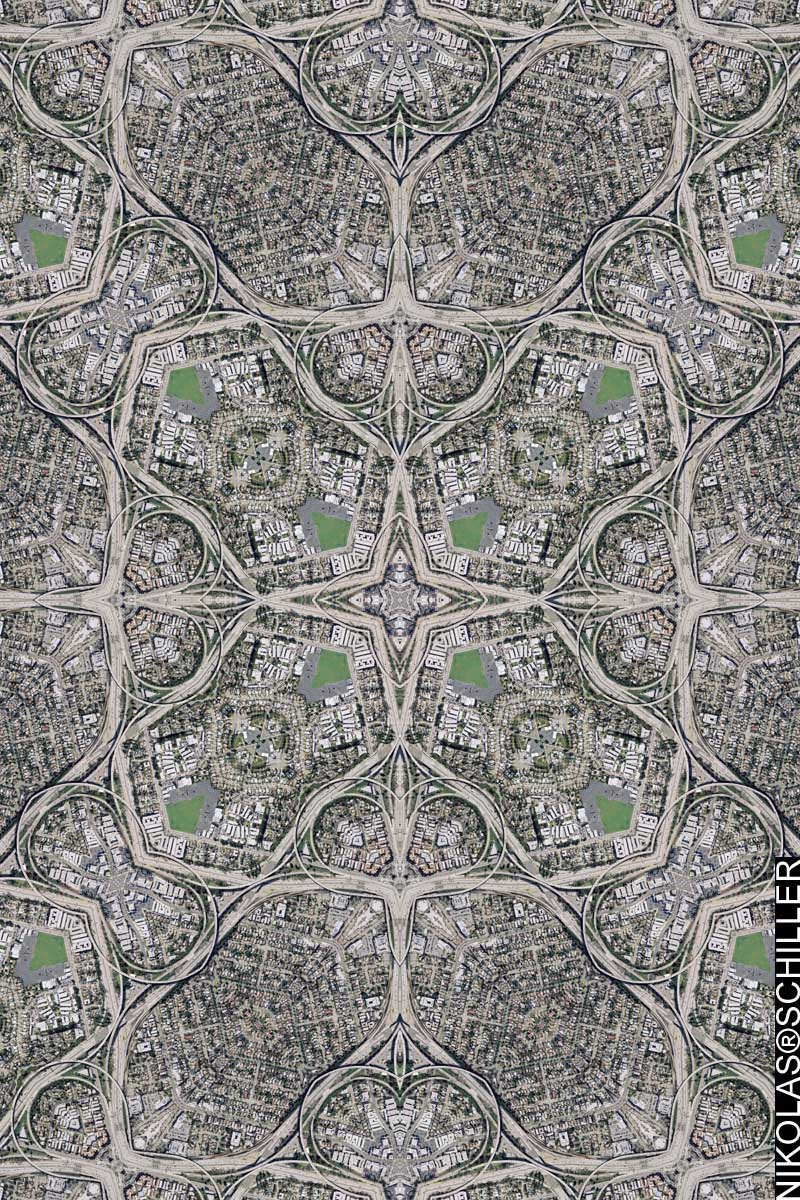
Using the center of 710 & 405 Quilt, which is in the Los Angeles Interchanges series, I constructed this beautiful globe.
+ MORE
10 & 110 Quilt
|| 8/1/2007 || 9:13 am || Comments Off on 10 & 110 Quilt || ||
710 & 405 Quilt
|| 7/24/2007 || 10:09 am || Comments Off on 710 & 405 Quilt || ||
105 & 405 Quilt
|| 7/21/2007 || 9:42 am || Comments Off on 105 & 405 Quilt || ||
90 & 405 Quilt
|| 7/20/2007 || 9:50 am || + Render A Comment || ||
10 & 405 Quilt
|| 7/19/2007 || 2:22 pm || + Render A Comment || ||
A few months ago I conceived this series titled’ “LA Interchanges.” The plan was to make maps of the highway interchanges throughout Los Angeles, California. I’ve made maps using highway interchanges before (MacArthur Maze Quilt and Omaha Intersection) so this concept is not necessarily new, but the idea of having a series dedicated to one geographic region with a focus on one aspect of the built environment is what makes this series interesting to me. Ultimately I’ll make a special Google Map Mashup for this series, but it’s still got a long way to go- there are a lot of interchanges. The plan is to slowly go North to South looking for interesting interchanges.
When obtaining the imagery for this project I discovered that the USGS has removed the 2004 imagery of Los Angeles! This means that I cannot make comparison maps like I did with Dodgers Stadium – 2004 – 2006. Moreover, I think the quality of the 2006 imagery is poor. It’s bleached out and fuzzy looking at the full resolution. After reading the meta-data I know why- its from scanned photographs taken in 2002! So it’s not really new imagery after all, but reprocessed old imagery.
View the Google Map of the intersection of I-10 & I-405 in Los Angeles.
View the Google Map of the Los Angeles Interchanges Series
+ MORE
Los Angeles Quilt
|| 1/30/2006 || 8:29 am || Comments Off on Los Angeles Quilt || ||

I’ve had this imagery for a long time but never did anything with it because I felt that the USGS made a poor decision in buying this imagery for the contracting company. Essentially, aerial photography taken in the afternoon (my guess is around 4pm) has large of shadows that obstruct the view of the ground and in my opinion, worthless. Nonetheless, I finally made something of downtown L.A. and as I look at it again, I think the shadows add architectural stitches to the quilt. Geographic Chiaroscuro.
+ MORE
©2004-2023 Nikolas R. Schiller - Colonist of the District of Columbia - Privacy Policy - Fair Use - RSS - Contact
::LAST 51 POSTS::
52 queries. 0.698 seconds.
Powered by WordPress


::THE QUILT PROJECTION::
Square |
Diamond |
Hexagon |
Octagon |
Dodecagon |
Beyond |
::OTHER PROJECTIONS::
The Lenz Project |
Mandala Project |
The Star Series |
Abstract Series |
Memory Series
|
Mother Earth Series
|
|
Misc Renderings
 |
::POPULAR MAPS::
- The Los Angeles Interchanges Series::MONTHLY ARCHIVES::
::LOCATIONS & CATEGORIES::


