Yesterday I went through all my 2008 entries and began to compile this year’s maps like I’ve done for previous years. However, this year I decided to expand the listing to include designs & animations that I’ve made.
The rationale for this expansion was rather simple: if these yearly listings are to be aggregates of my creative work, they might as well include everything. I’m a bit tepid about going through the previous years to find creations that I might have missed, but I imagine that I’ll get around to doing it. Also, since this website has gone public, I’ve found myself sharing content that I did not create and this makes it more difficult to decipher what I’ve created and what I have found on-line & decided to share here.
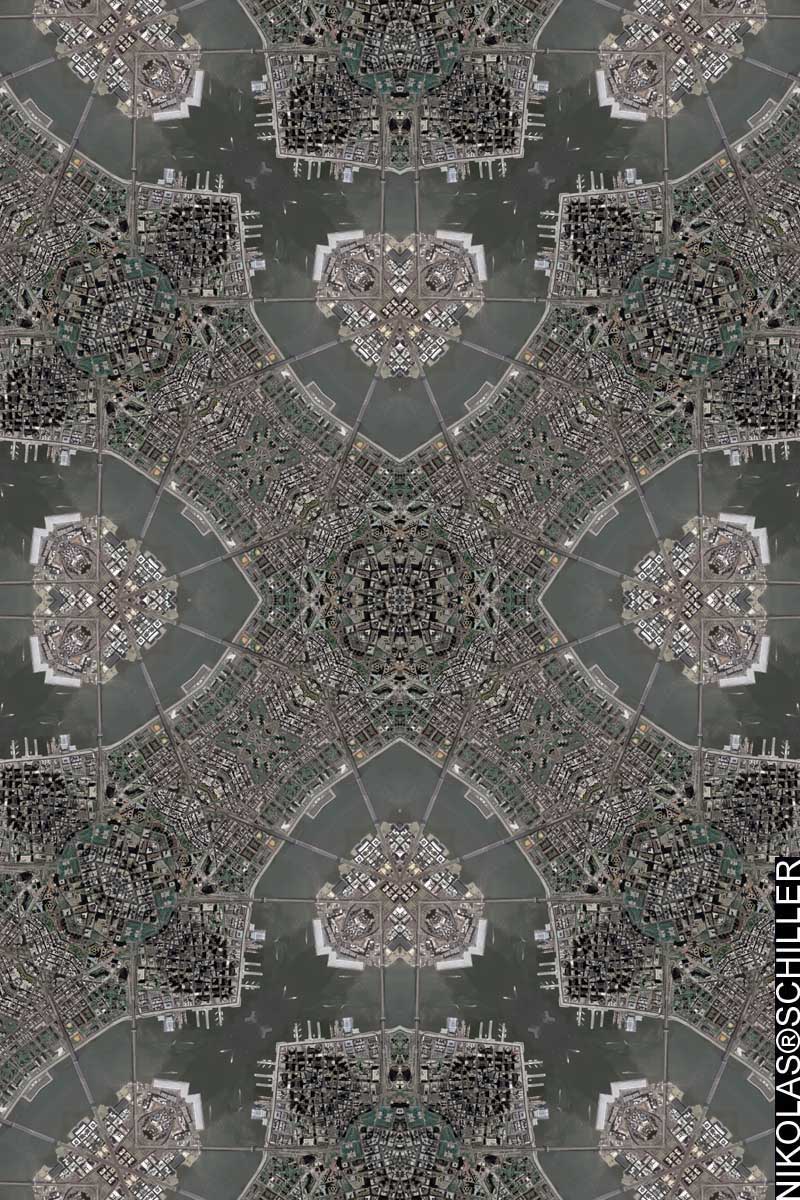
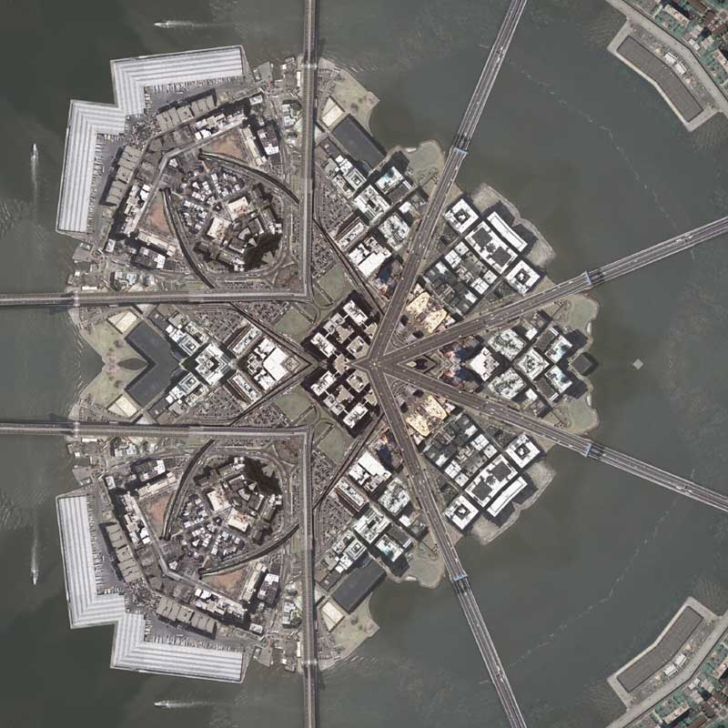
Today’s creation is the start of a new series of New York City maps that I expect to make in the coming days. This morning I discovered that the USGS has released newer imagery of New York City that was taken in March of 2006.
However, as with other imagery, I’ve found that the older imagery is of better quality. Its not that this new imagery is fuzzy or not as sharp, but rather I found the coloration to be more subdued. The 2004 imagery, which I used to produce all of my previous New York City maps, is more vivid and the colors just look nicer. With that issue aside, I’ve made a few different tessellations that I’m going to be using for the next set of maps of New York City.
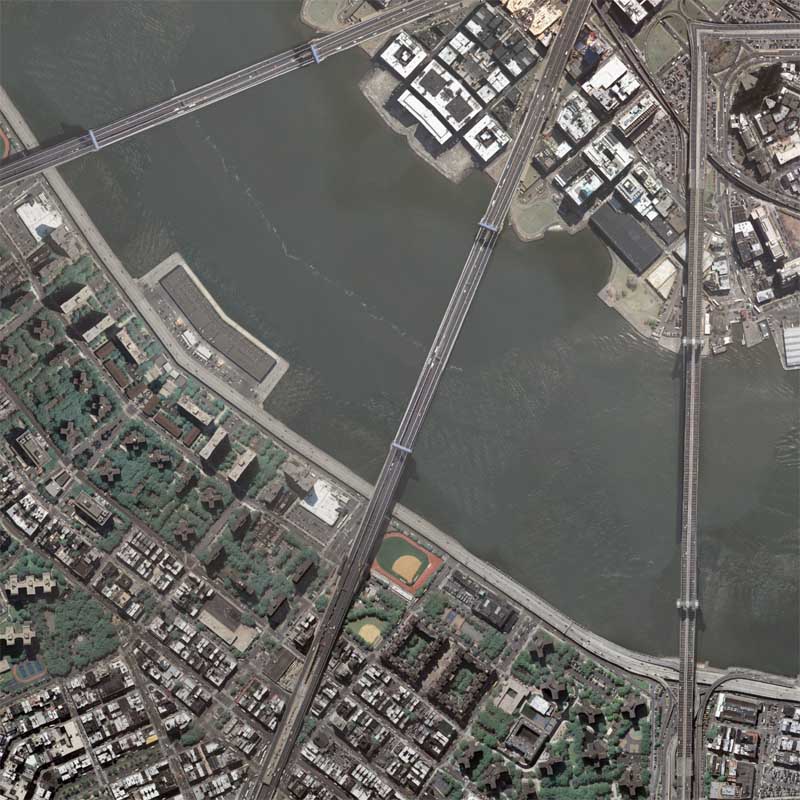
This map shows the Manhattan Bridge and the Brooklyn Bridge, as well as a tiny portion of Brooklyn and a larger portion of Manhattan’s Lower East Side. I tried a few different Quilt projection shapes and finally settled on using the Diamond Quilt Projection because I like the way the bridges create a square box within the diamond layout. I have made a derivative tessellation of this map, but I think I’m going to use some of the other imagery first.
View the Google Map of the Manhattan & Brooklyn Bridges.
View the rest of the map’s close-up details:


UPDATE – This map was selected to be used for the cover of Kazim Ali‘s new book “Bright Felon: Autobiography and Cities”

Released September 1st, 2009
Related New York Entries:
- THE EXPECTANT HAND - The Mahoning Dispatch, June 04, 1909
- The Strange Narcotics Used in Asia and South America - The New York Sun, February 8th, 1880
- The 1910 Publication Calendar of the New York Tribune from the Chronicling America Newspaper Collection [100 Year Old News]
- The 1910 Publication Calendar of the New York Sun from the Chronicling America Newspaper Collection [100 Year Old News]
- A Diagrammatic Photograph Showing The American Warship, The Delaware, Blowing Up New York City
- Bright Felon: Autobiography And Cities By Kazim Ali Is Now Available
- A Gigapan of the New York Public Library Quilt
- [FOUND MAP] New York City: The 51st State
- Commission: Yankee Stadium Quilt
- New York City Photo Series #6 - Looking at the southeastern skyline
- New York City Photo Series #5 - One Worldwide Plaza
- New York City Photo Series #4 - Ludlow & Rivington
- New York City Photo Series #3 - Corner of Rivington & Essex - Timelapse
- New York City Photo Series #2 - Corner of Rivington & Essex
- New York City Photo Series #1 - Economy Candy
- Photo of my presentation at the New York Public Library
- My New York Map Society Presentation at the New York Public Library
- Ordered Today: New York Public Library Quilt
- New York Public Library Quilt
- Madison Square Garden Quilt
- Mark Your Calendars!
- Manhattan & Brooklyn Bridge Quilt
- Animated Map Showing the History of New York City's Subway System
- Albany Droste Quilt
- Vassar Quilt Refraction
- Vassar Quilt #2
- Vassar Quilt
- Rochester Quilt #2
- Birth of a City [Rochester,NY]
- Rochester Quilt
- 2008 Urban America Calendar
- Stuyvesant Quilt #3
- Stuyvesant Quilt #2
- Stuyvesant Quilt
- My first album cover: Thievery Corporation - "Supreme Illusion"
- Cities & Nature - My first book cover
- Williamsburg Quilt #2
- Williamsburg Quilt
- Lower Manhattan Quilt #2
- Lower Manhattan Quilt
- Central Park Quilt - North #2
- Central Park Quilt - North
- Central Park Quilt - South #2
- Central Park Quilt - South
- 911 Mandala
- more morning notes
- morning notes
- pearl earring


