The Daily Render

by

A Digital Scrapbook for the Past, Present, and Future

| FRONT PAGE | GEOSPATIAL ART | DC HISTORY / TIMELINE | NEWS | COLONIST | FOUND MAPS | FRACTALS |
| PHOTOGRAPHY | ANTIQUE | DESIGN | VIDEO | | CONTACT |

Boston Common Quilt, revisited
|| 4/26/2008 || 11:09 pm || Comments Off on Boston Common Quilt, revisited || ||

The other week I published two maps of Boston Common on this website. Since then, I’ve had numerous visits to my website from people searching for the Boston Common quilts.

Since I am not a quilter, I did not know that there was already type of patchwork called Boston Common. The real irony is that last week I tried making almost the exact type of geographic quilt design but gave up because it was taking too long to make.

From a visual standpoint, the layout of the Boston Common patchwork design looks very similar to my square quilt projection. I wonder what other quilt design styles I’ve accidentally copied? I’ll find out in due time.


Streetfilms: Ciclovia in Bogota, Colombia
|| 4/15/2008 || 8:55 am || Comments Off on Streetfilms: Ciclovia in Bogota, Colombia || ||

Continuing on the topic yesterday’s post about how my neighborhood used to be a bike track, I figured that I should follow-up the entry with something bicycle related. I saw this video a few months ago and even sent it to my old Urban Geography Professor. The 7 minute video is about Ciclovia in Bogota, Colombia, which is a a weekly event in which over 70 miles of city streets are closed to traffic. As you can see in the video, residents come out to walk, bike, run, skate, recreate, picnic, do aerobics, and basically enjoy the city safely and pollution-free.

I found the video to be very inspirational. In the back of my mind, I began constructing the theoretical Ciclovia map of Washington, DC. What roads would be closed? Would people take part en masse? Or would it be relegated to some corporate sponsored yearly event like Bike to Work Day?

Frankly, I don’t know, but I think it would be fun to start small. DC currently has miles 17 miles of bike lanes, and I don’t think people would give up their coveted on-street parking in favor of bicyclists, so most streets can’t be closed off. However, there are some streets that could be (and sometimes are) made one-way (P Street) and there are some wide streets that could be partially closed (15th Street). In this respect, DC could do a Cyclovia and it wouldn’t require that much work.

But what about participation? If you delineate it, will they ride on it? That being, if there was to be a Cycloviva, would there be enough people riding their bikes to justify the road closures? Frankly, I don’t think there would be enough sustained interest if it were a weekly event– not enough bicyclists in DC. Instead I think it would work better as a seasonal event. Cyclovia Spring, Cyclovia Summer, etc. and over time there might be a critical mass.

Related Bicycle Entires:

+ MORE


MySpace has fixed it’s front page—- 7 months later…
|| 2/23/2008 || 9:36 pm || Comments Off on MySpace has fixed it’s front page—- 7 months later… || ||

Back in August of 2007 I discovered something I thought was awry on MySpace’s front page. It was showing the exact same number of videos uploaded each day. I was like, “this is a lie,” its impossible that the EXACT same number of videos were uploaded each day. The only way this was theoretically possible was if there was an upper ceiling on the number of videos that MySpace could handle. As in, their servers could only process X number of videos each day. Yet that theory is based on the premise that there was ample content being uploaded on a daily basis. I concluded that this lack of updates was out of laziness. The worst part of this lack of genuine updates was that MySpace was trying to combat phishing, which was based on people being taken a to fake login page and entering their login & password information. So if MySpace’s login page was static and not changing, yet at the same time incorrectly stating that there were X amount of new videos uploaded each day, I wanted to document this egregious error. Nearly every other day when I was asked to login on MySpace’s front page, I would do a screen grab similar to the ones shown above & below. In all, I collected over 100 different screen grabs and in due time I plan on making an aggregate graphic of all of the screen grabs in the order that they were collected. I am posting this today because I believe that this project is now over. It looks as if MySpace has now fixed this error; it only took 7 months.


Spotting a Slovenian Splogger
|| 2/22/2008 || 8:15 pm || Comments Off on Spotting a Slovenian Splogger || ||

On April 14th, 2007, Quang at the popular blog Haha.nu posted the entry above about my maps titled “Patterns from Google Maps.” When I discovered this blog entry I left a comment with the author stating that I DID NOT use imagery from Google Maps. I was hoping that he’d change the name of the entry so that others would not illegally use the imagery from Google Maps. I was also hoping that he’d follow my on-line usage request and include the name of the map and a direct link back to it’s respective blog entry. He ultimately edited the blog entry to include the names of the maps, but he kept the name of the original posting.

Last night I noticed a new link coming to my website with roughly the same name, but from a completely different website. Essentially, the person scraped some text from Quang’s original entry and used the exact same map of Charleston, South Carolina (without mentioning that it was Charleston, South Carolina– which was my original issue!). If the person would have simply changed the name of the posting I would have simply suspected this outright plagiarism, but gauging from the stats below, its quite clear that it was a direct copy with minimal revision. I had not received a visit linked from Quang’s entry in months, so I chose the screen grab below because I believe that I was able to isolate when the splogger copied the content and where the splogger is located.

Wikipedia defines as splog as:

Spam blogs, sometimes referred to by the neologism splogs, are artificially created weblog sites which the author uses to promote affiliated websites or to increase the search engine rankings of associated sites. The purpose of a splog can be to increase the PageRank or backlink portfolio of affiliate websites, to artificially inflate paid ad impressions from visitors, and/or use the blog as a link outlet to get new sites indexed. Spam blogs are usually a type of scraper site, where content is often either inauthentic text or merely stolen (see blog scraping) from other websites. These blogs usually contain a high number of links to sites associated with the splog creator which are often disreputable or otherwise useless websites.

Since the author didn’t directly copy the text, rather summarized it, I wouldn’t have automatically suspected it to be a splog. However, at the end of every posting the author asks for a donation (yum, coffee!) and if you look at the screen shot above, you can see that the blog is completely full of ads. If the splogger took a few minutes to layout the website so that it wasn’t booby trapped with ads I might have not put it all together, but in the end, I believe I spotted a Slovenian splogger. What I find interesting is that there are people who actually read this splog! I wonder if the readers know the source of the pillage content? or if they even care?


TONIGHT: L (A) T T I T U D E S
|| 2/21/2008 || 2:47 pm || Comments Off on TONIGHT: L (A) T T I T U D E S || ||

The Washington Post has this listing:

Time for an Arty Party Weekend
By Lavanya Ramanathan
Thursday, February 21, 2008; Page C13

The box wine is guaranteed to be flowing through the weekend, as several exhibitions open with bashes at galleries as well as unconventional spaces across the city.

Just a few you might want to drop by:

Tonight at the Washington DCJCC’s Ann Loeb Bronfman Gallery, catch the new show “L(A)ttitudes,” which features 10 contemporary artists from five countries; their work dissects the fluid and subjective nature of the idea of “borders” marking Israel and Palestine. Included are two installations, photographs of the separation wall and works re-imagining the landscape via maps. The reception is from 5 to 7 p.m. The show is up Sundays-Thursdays 10 a.m.-10 p.m. and Fridays 10 a.m.-4 p.m., through June 2. 1529 16th St. NW. 202-777-3208.

Hope to see you!


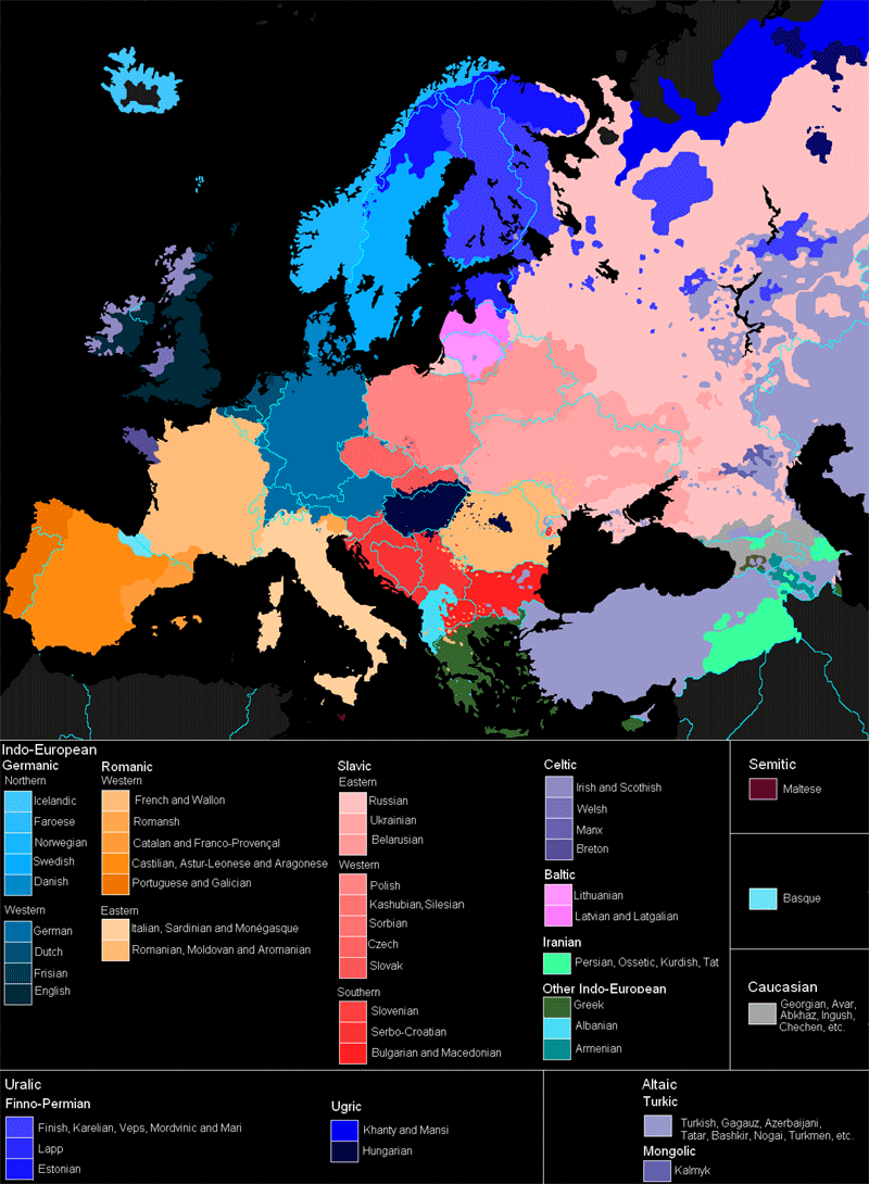
Map of the Languages of Europe
|| || 10:26 am || Comments Off on Map of the Languages of Europe || ||


The Languages of Europe

Following up yesterday’s posting about languages, I am posting this map I found on Wikipedia that shows where different languages are spoken throughout Europe. I find this type of map quite interesting to view, yet I feel it lacks one important cartographic aspect: overlap. Basically, the simplified map above does not show where multiple languages are spoken, rather only where the dominant languages are. By not including this important aspect we are given a nicely colored map, yet in reality there is a lot more merging of colors because there are geographies that have multiple languages spoken.


It’s too bad I don’t know Hebrew because tonight’s exhibition will most likely include some Hebrew on maps of Israel.


#UPDATE – I have updated the map to the latest version on Wikipedia, which was made in February 25, 2009.


Related Europe Entries:

+ MORE


over-projection after three derivatives
|| 4/19/2007 || 11:27 pm || Comments Off on over-projection after three derivatives || ||

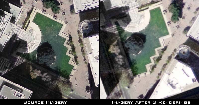
I decided to compare the unmodified imagery of Oakland’s City Hall Plaza with the same location after 3 derivative maps (specifically a detail from Oakland Quilt #5). The result is quite interesting because it shows that the template I’ve been using for almost a year is not 100% perfect, which I knew already, but never cared to quantatively find out.

First there is too much light because the imagery on the right is slightly brighter. I did not compare the RGB histograms to see exactly how bright it is, but will check out in the future. Secondly, and more importantly, the template ever-so-slightly over-projects the imagery. The visual result is a slightly fuzzy version of the original, which, in most cases, does not matter because it’s ONLY noticable when shown at it’s full size. Once the map is reduced in size the fuzziness goes away.

To discover this I placed the original imagery on top of the used imagery and changed the opacity so that I could line up park on top each other and to match them I had to stretch the original imagery about .03%. Which after being used for 3 maps, this means my current template over-projects the imagery approximately .01%. This isn’t all the bad, but it means I need to do a slight resize to the template. Technically this means each map is 180 pixels too large, but honestly, I find that number a bit too high….


Al-Jazeera VS. CNN on Banksy’s show in LA
|| 9/17/2006 || 10:22 pm || Comments Off on Al-Jazeera VS. CNN on Banksy’s show in LA || ||

My favorite culture jammer / art terrorist / meme warrior, Banksy had an exhibit in LA this weekend. I posted the info about it last Friday night on MySpace. Since then there has been AP, UPI, and Reuters news releases which resulted in over 370 news stories about his exhbit.

Of note is how the artist is covered in the press. CNN literally attacks the messenger (the elephant) instead of addressing it’s message (poverty, social justice, etc.), while Al-Jazeera using the Reuters report treats the exhibit in a more balanced tone. Few of the articles even reference this similar stunt where he painted farm animals (see below)).

+ MORE


Sensors Spatial Analysis of Tularemia on the National Mall
|| 10/6/2005 || 4:47 am || Comments Off on Sensors Spatial Analysis of Tularemia on the National Mall || ||

An attempt at being funny (cartographic humor) using a cute red-eyed rabbit as an icon of the locations of the sensors that found “rabbit fever.”

The other (below) is a quick & dirty spatial analysis of the area around the protests made using NASA’s World Wind (free), Google Earth (free), and Photoshop. I used the measure tool in Google Earth to measure a mile from the Lincoln Memorial, I used World Wind to acquire the USGS imagery, and Photoshop to draw the circles. The Lincoln Memorial’s circle served as the template for the other two sites.

+ MORE


Cessna Analysis
|| 5/13/2005 || 11:18 am || 1 Comment Rendered || ||

Via Seattle Times

The aircraft flew over the vice president’s residence, a senior federal security official said, came within moments of reaching the White House and was close to being shot down.

Let’s use World Wind to visually see how close this plane got, and more importantly assess what a lack of security this really shows…..

Using a screen shot from World Wind and a picture of a Cessna, I came up with this rudimentary analysis of where the plane was and the possible debris area if the plane was to have been shot down by the armaments on top of the White House (click on the image to view the full size image).

Of course this is a very rough spatial analysis of the potential debris area, but the proximity to the White House the plane made it to is dumbfounding. The article in reference above stated:

Two lost aviators flying with outdated maps from a rural Pennsylvania airstrip yesterday triggered a red alert and the frantic evacuation of the White House, the Capitol and the Supreme Court before they were intercepted by Air Force jets firing warning flares.

All I can says is: OUTDATED MAPS MY ASS! You can see the Washington Monument from the air all the way out in Rockville, MD (I’ve seen it from the 10th floor of a high-rise at the Metro stop) and it is well known in the aviation community that there is a restricted fly space over DC. The pilots didn’t need maps to know that they were in restricted fly-space, they could see the Washington Monument quite easily and continued to fly toward DC.

The graphic above, nor most of the media accounts fully explains the direction the pilots were going- were they heading due south or were they heading southeast. If they were heading due south, they would have also crossed into the no-so-restricted airspace of DCA and might have gotten very close to some very large planes taking off or landing (I do not know the direction of the winds on that day). If they were heading southeast, then the analysis above would most likely be somewhat correct. (Do you work in that area?)

On top of the lame excuse for outdated maps, why didn’t they respond to any calls from the FAA? Once they entered restricted airspace, I imagine there would have been some attempts at notification. So why didn’t they respond? This is standard protocol for any pilot.

If you ask me, if this is all very very fishy. They could have dumped a canister of aerosolized anthrax over the DC area and then chucked the canister out the window to get rid of any evidence. I could easily make another map showing the theoretical diffusion of such a situation. What if that plane was holding a few pounds of radiological material onboard? If that plane was shot down, downtown Washington, DC would be a radioactive mess, a mess that could have been prevented.

I bet this was simply a test on the emergency response system in the DC area. The scare during Reagan’s funeral seems wholly legitimate compared to this event. This one seems too perfect. Have a small, harmless plane cross over into the restricted airspace of DC, gauge how fast the emergency response apparatus acts, and then see how it can be tinkered to not allow such an event to take place again. The whole “we were lost” line is such utter bullshit, and I think this “test” seems like a much better explanation.

update via WJLA:

Jill Martin says from her home in Akron, Pennsylvania, that she believes the Washington incident was a simple mistake. She says her husband was discussing the flight with her last night after he and Sheaffer made their flight plans and was talking “all about the no-fly zones and how they were going to avoid them.”

If my theory is incorrect, he must be one hell of a stupid pilot that shouldn’t hold the yoke of a plane again. His teacher too.

===/=== 3:30pm===\===
After looking at the Washington Post map of the flight path, I’ve found my analysis to be completely incorrect. The plane came from the northeast and flew over the U.S. Naval Observatory on its flight out of DC, thus my graphic above is severely inaccurate. Oh well, it was fun to make!



The Daily Render By
A Digital Scrapbook for the Past, Present, and Future.

©2004-2023 Nikolas R. Schiller - Colonist of the District of Columbia - Privacy Policy - Fair Use - RSS - Contact


::LAST 51 POSTS::

Fair Use


54 queries. 0.798 seconds.
Powered by WordPress

Photo by Charlie McCormick
Nikolas Schiller is a second-class American citizen living in America's last colony, Washington, DC. This blog is my on-line repository of what I have created or found on-line since May of 2004. If you have any questions or comments, please contact:

If you would like to use content found here, please consult my Fair Use page.

::THE QUILT PROJECTION::

Square
Square

Diamond
diamond

Hexagon
hexagon

Octagon
octagon

Dodecagon
Dodecagon

Beyond
beyond

::OTHER PROJECTIONS::

The Lenz Project
Lenz

Mandala Project
Mandala

The Star Series


Abstract Series
abstract

Memory Series
Memory

Mother Earth Series
Mother Earth

Misc Renderings
Misc

::POPULAR MAPS::

- The Los Angeles Interchanges Series
- The Lost Series
- Terra Fermi
- Antique Map Mashups
- Google StreetView I.E.D.
- LOLmaps
- The Inaugural Map
- The Shanghai Map
- Ball of Destruction
- The Lenz Project - Maps at the Library of Congress
- Winner of the Everywhere Man Award

::MONTHLY ARCHIVES::


::LOCATIONS & CATEGORIES::

  • 2004 Elections (2)
  • 2008 Elections (35)
  • 2014 Elections (4)
  • 2016 Elections (2)
  • ACLU (3)
  • Activism (287)
  • Adbusters (13)
  • Advertisements (33)
  • aerial photography (19)
  • Analysis (31)
  • Animals (30)
  • animated gif (7)
  • Animation (25)
  • Antique (104)
  • Apple (1)
  • Arabic (17)
  • Architectural Archeology (9)
  • Artomatic (25)
  • Astronomy (15)
  • Astrophotography (9)
  • Audio (2)
  • Awards (3)
  • Backpacking (2)
  • banner graphics (5)
  • Beat Google to the Map (56)
  • bicycle (23)
  • Birds-Eye View (5)
  • Blaeu (10)
  • Book Covers (7)
  • Bridge (10)
  • Building (15)
  • calendar (28)
  • calligraphy (6)
  • Capital (61)
  • Cars (18)
  • Cartography (74)
  • Cartoon (9)
  • Celestial (31)
  • Censorship (32)
  • Chinese (7)
  • Chronicling America (34)
  • Classroom (5)
  • Clothing (12)
  • Commentary (76)
  • Commissioned (27)
  • Credit Cards (3)
  • Crime (12)
  • Cyrillic Alphabet (1)
  • DAILY LINKS (30)
  • Dance (2)
  • DC History (93)
  • Design (102)
  • Digital Scrap (5)
  • Election (11)
  • ESA (3)
  • Facebook (19)
  • Fantasy (3)
  • Fashion (23)
  • Fast Food (2)
  • FBI (7)
  • Flag (15)
  • flickr (4)
  • Found Map (56)
  • French (9)
  • Gallery (54)
  • Gardening (25)
  • General (256)
  • George Bush (12)
  • GIS (69)
  • GMO Labeling (4)
  • Google (31)
  • Google AdSense (4)
  • Google AdWords (3)
  • Google Earth (28)
  • Google Maps (47)
  • Google Reader (4)
  • Google Streetview (8)
  • GPS (7)
  • Graffiti (5)
  • Greek (4)
  • Green (72)
  • Green Party (18)
  • Healthcare (15)
  • Highway (35)
  • Hiking (2)
  • Hipster (2)
  • history (151)
  • Holidays (10)
  • House Party (2)
  • Hubble Telescope (2)
  • Humor (88)
  • In The News (88)
  • Insects (2)
  • Interactive (74)
  • Interiors (4)
  • IP Trace (28)
  • Latin (22)
  • Law (15)
  • Lecture (11)
  • Legislation (19)
  • Library (21)
  • Library of Congress (66)
  • Location (1,018)
  • LOLMaps (3)
  • Mass Transit (6)
  • Memorandum (2)
  • meta-data (32)
  • Mobile Phone Applications (1)
  • Movie (3)
  • MrSID (4)
  • MSN (5)
  • Museum (5)
  • Music (48)
  • MySpace (6)
  • NASA (10)
  • National Archives (3)
  • News (182)
  • Obituary (2)
  • Oil (4)
  • Ornithology (4)
  • orthophotography (4)
  • OSCE (16)
  • Photography (134)
  • Poetry (18)
  • Portuguese (1)
  • postmodern (8)
  • QR code (9)
  • QTVR (4)
  • Radio (3)
  • Renderings (675)
  • RSS (3)
  • Seasons (12)
  • Sold (40)
  • Spanish (7)
  • Speech (5)
  • Sports (1)
  • Stadium (40)
  • statehood (94)
  • Statistics (2)
  • Stellarium (4)
  • Stereogram (1)
  • Street (21)
  • Street Art (10)
  • Submissions (5)
  • Tattoo (2)
  • Testimony (2)
  • time-lapse (19)
  • Torture (3)
  • Transportation (6)
  • TV (23)
  • Twitter (5)
  • University (41)
  • Update (24)
  • Vegetarianism (2)
  • Video (49)
  • Vimeo (18)
  • visualization (36)
  • Washington Critic (2)
  • Weather (19)
  • Web Crawler (9)
  • Wikipedia (14)
  • Wordpress (4)
  • Wordpress Upgrade (2)
  • World Wind (3)
  • Yahoo (6)
  • YouTube (113)
  • Zodiac (23)


  • thank you,
    come again!