The Daily Render

by

A Digital Scrapbook for the Past, Present, and Future

| FRONT PAGE | GEOSPATIAL ART | DC HISTORY / TIMELINE | NEWS | COLONIST | FOUND MAPS | FRACTALS |
| PHOTOGRAPHY | ANTIQUE | DESIGN | VIDEO | | CONTACT |

The National Archives Cross
|| 10/24/2008 || 1:38 pm || Comments Off on The National Archives Cross || ||

: rendered at 18,000 X 12,000 :

So far I’ve made two other crosses: Mount Pleasant Cross and Memphis Cross. I am pretty sure how to make these now and future maps of this type will be added to it’s own special category on the sidebar. The cross above was chosen out of about 8 different tessellations and within this map is the National Archives at the center of the cross (hence the name), the Federal Trade Commission, the Robert F. Kennedy Department of Justice Building, the Federal Bureau of Investigation, the Navy Memorial– which features a map of the western hemisphere (below), the Winfield Scott Hancock statue, the Grand Army of the Republic Memorial, and portions of the National Gallery of Art Sculpture Garden and the west building of the National Gallery of Art, which make the vertical and horizontal stripe.

For reference, click here to view the outdated Google Map of downtown Washington, DC.

: detail of the National Archives :
: detail of the Navy Memorial :

View the rest of the details:

+ MORE


[Commission] Shirlington Quilt
|| 10/15/2008 || 6:16 pm || Comments Off on [Commission] Shirlington Quilt || ||

: rendered at 9,000 X 6,000 :

I’ve been working on this commissioned map for a few months now. It was originally going to be Paris, but we decided to it would be easier to make a map of their house. I spent some extra time transforming the nearby highway into a heart (below) to signify the love between the husband and wife. I think it looks beautiful :-) It will be placed in the client’s home, which is featured within the map.

View the Google Map of the Shirlington neighborhood of Arlington, Virginia.

: detail :

View the rest of the details:

+ MORE


Saint Paul Quilt
|| 9/29/2008 || 11:42 am || Comments Off on Saint Paul Quilt || ||

: rendered at 18,000 X 12,000 :
Saint Paul Quilt

It’s been quite a long time since I’ve made one of my signature quilt projection maps. On one hand I haven’t been inspired lately to make any new maps based on this technique. On the other hand, there are only a few American cities that I have yet to map, and Saint Paul, Minnesota was one of them. I was originally going to make this map during the Republican National Convention, but was sidetracked due to other work. Unlike the previous quilt projection maps that I have made most recently, which involved at least one recursive tessellation, this map employs the original style of my hexagon quilts.

This coming Saturday I will be in New York City for the New York Map Society’s monthly meeting. In preparation for my talk, I don’t expect to be blogging much this week because I intend on spending much of my spare time preparing my notes for the talk. If you are in New York, I hope you can make it!

View the Google Map of downtown Saint Paul, Minnesota.

: detail :

View the rest of the details:

+ MORE


My Weekend in Photos [8/22-8/24]
|| 8/25/2008 || 6:46 am || Comments Off on My Weekend in Photos [8/22-8/24] || ||

The photos below document some of what I saw on Friday, Saturday, and early Sunday morning.

View the rest of the photographs:

+ MORE


Meridian Hill Park Hexagon Tessellation
|| 8/2/2008 || 1:59 pm || Comments Off on Meridian Hill Park Hexagon Tessellation || ||

: saved at 15,000 X 10,000 :

This is the first time I’ve made a tessellation using hexagon as the basis for the pattern. Normally, I simply use a square because its the easiest to tessellate. The last map I made using Photoshop was Clayton Quilt #3, which was constructed using one square tile six times and did not exhibit radial symmetry like most of my other Qulit projection maps.

This time around I used center portion of the source tile that I used for Meridian Hill Park Quilt #4 and to switch things up a bit, I cut out a perfect hexagon from the the tile instead of using the tile’s square shape as basis for the tessellation. With one hexagon cut out, I merely duplicated it and moved it around to create the irregular tiling above. The difficulty was that I had to adjust the hexagon tiles so that they were not overlapping. It wasn’t that difficult per se, but it took awhile to get them all lined up perfectly. I am quite pleased with the result and figure that I will use this process again sometime in the not-so-distance future.

View the Google Map of Meridian Hill Park in Washington, DC.

: detail :

View the rest of the map’s close-up details:

+ MORE


Meridian Hill Park Quilt #4
|| 7/26/2008 || 4:08 pm || Comments Off on Meridian Hill Park Quilt #4 || ||

: rendered at 18,000 X 12,000 :

I’ve been doing some research on an old sculpture that used to be in Meridian Hill Park that will be featured in an upcoming posting. In preparation, I decided to make a quilt projection map of the park using the newest available imagery. Unlike the previous three, which were some of the first to use my recursive tessellation technique, the newer imagery captures less of the area surrounding the park and more detail of the park itself. This is simply due to the fact that the newer imagery has a high spatial resolution than the older imagery, which correlates to more detail, but less geographic coverage. Since the aerial photography was taken in the early spring, the fountains were still in their winter slumber and I imagine that if it were taken in the summer the coloration would be vastly different.

When constructing this map, I used my new technique hypothesized in May and first rendered a hexagon tile and then took a portion of that tessellation and used it here. The result, which I am seeing for the first time, is that you can see the hexagon shape around the center of this square quilt projection map quite easily. From my understanding, depending on the location of the recursive sampling within the first map, I’ll be able to see it’s respective geometry embedded in the second map. However, I think it’s nearly impossible to fully gage the geometry of the original map after two recursions because each subsequent sampling makes it more difficult to see the geometry present in the previous map.

View the Google Map of Meridian Hill Park in Washington, DC.

: detail :

View the rest of the map’s close-up details:

+ MORE


New York Public Library Quilt
|| 6/25/2008 || 7:50 pm || Comments Off on New York Public Library Quilt || ||

: rendered at 18,000 X 12,000 :

This fractal octagon quilt projection map was recursively rendered four times before the final result above. It took approximately two hours for each rendering to complete and then each tessellation was sampled while maintaining the source spatial integrity. Altogether this map took about 12 hours of rendering time and post-processing time to complete. I intend on printing this out for the upcoming lecture.

View the Google Map of the area around the New York Public Library in New York City.

: detail :

View the rest of the details:

+ MORE


Madison Square Garden Quilt
|| 6/10/2008 || 6:17 pm || Comments Off on Madison Square Garden Quilt || ||

: rendered at 18,000 X 12,000 :

Using my new procedure, I pre-rendered 2 tiles to create this third derivative map of Madison Square Garden in Midtown Manhattan. It looks very similar to Hirshhorn Quilt (they are both circular buildings) but they are composed of aerial photographs taken at different spatial scales. The NYC imagery has been downsampled to 2ft per pixel compared to DC’s imagery which is at 6 inches per pixel or a difference of about 16 times less detail (I think). Up next will probably be the New York Public Library, which was actually in the first tessellation, but dropped from the second.

View the Google Map of Madison Square Garden in New York City.

: detail :

View the rest of the details:

+ MORE


Manhattan & Brooklyn Bridge Quilt
|| 6/7/2008 || 6:12 pm || Comments Off on Manhattan & Brooklyn Bridge Quilt || ||

Yesterday I went through all my 2008 entries and began to compile this year’s maps like I’ve done for previous years. However, this year I decided to expand the listing to include designs & animations that I’ve made.

The rationale for this expansion was rather simple: if these yearly listings are to be aggregates of my creative work, they might as well include everything. I’m a bit tepid about going through the previous years to find creations that I might have missed, but I imagine that I’ll get around to doing it. Also, since this website has gone public, I’ve found myself sharing content that I did not create and this makes it more difficult to decipher what I’ve created and what I have found on-line & decided to share here.

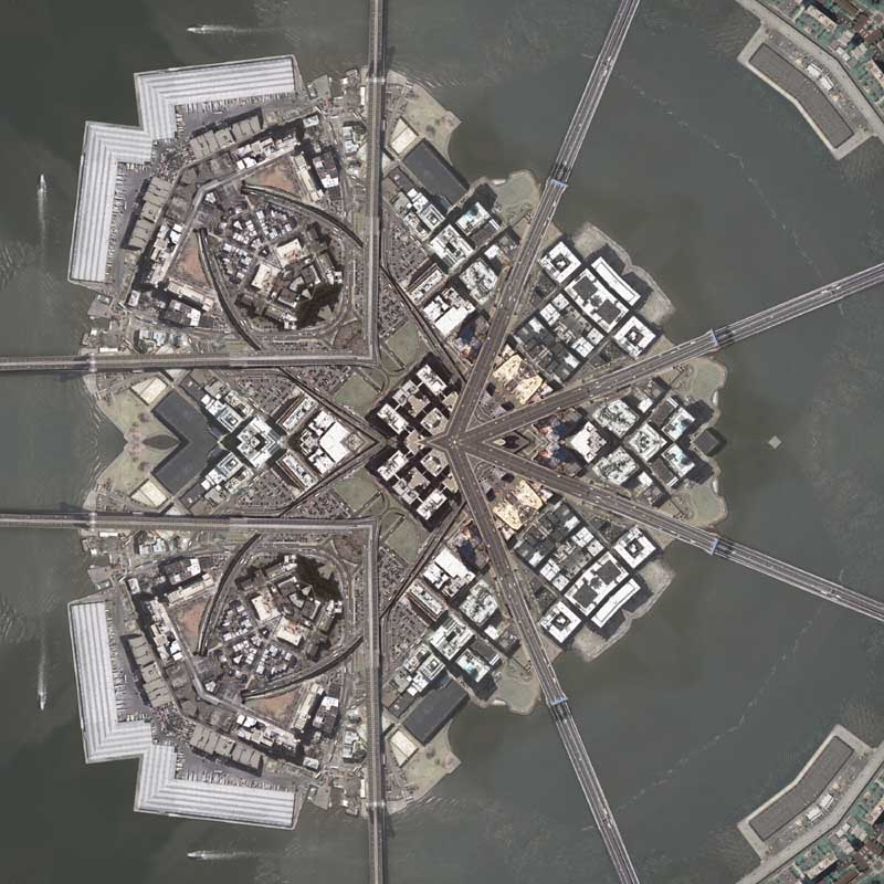
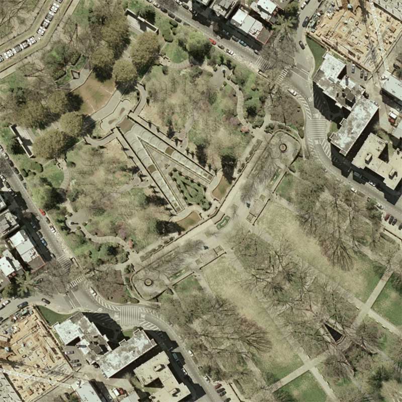
Today’s creation is the start of a new series of New York City maps that I expect to make in the coming days. This morning I discovered that the USGS has released newer imagery of New York City that was taken in March of 2006.

However, as with other imagery, I’ve found that the older imagery is of better quality. Its not that this new imagery is fuzzy or not as sharp, but rather I found the coloration to be more subdued. The 2004 imagery, which I used to produce all of my previous New York City maps, is more vivid and the colors just look nicer. With that issue aside, I’ve made a few different tessellations that I’m going to be using for the next set of maps of New York City.

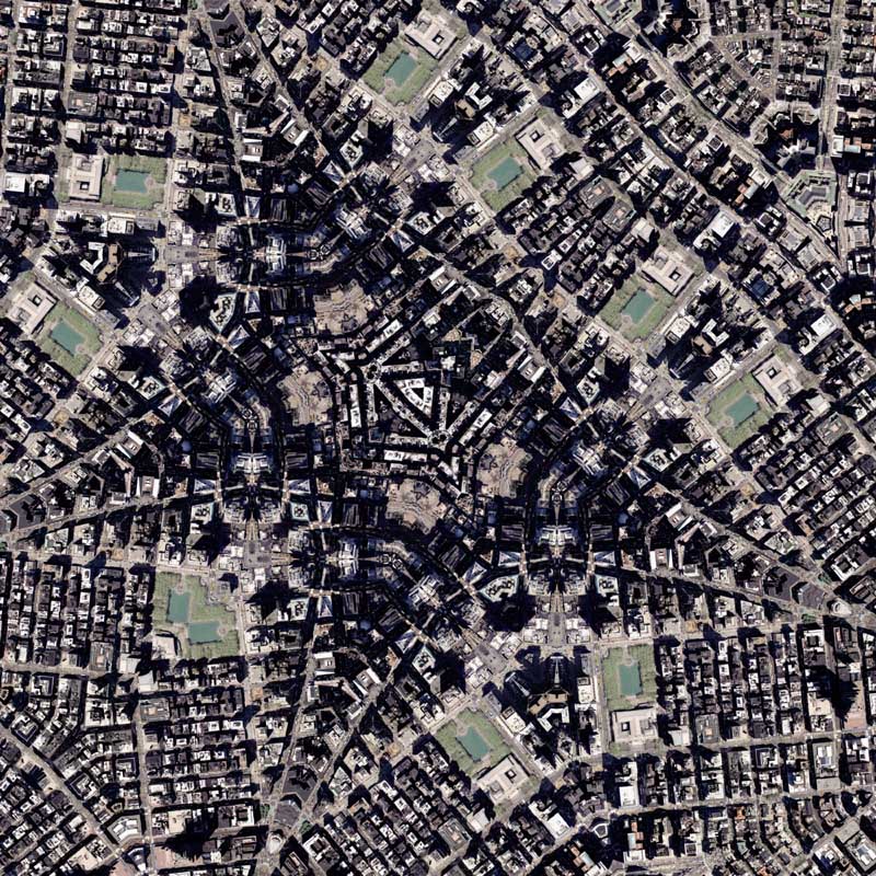
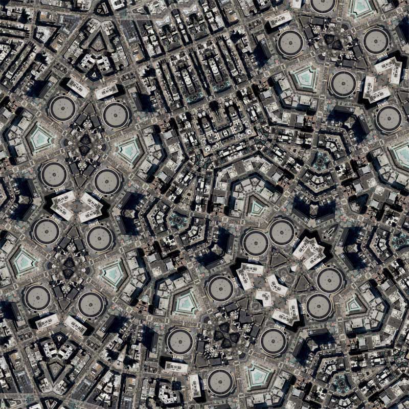
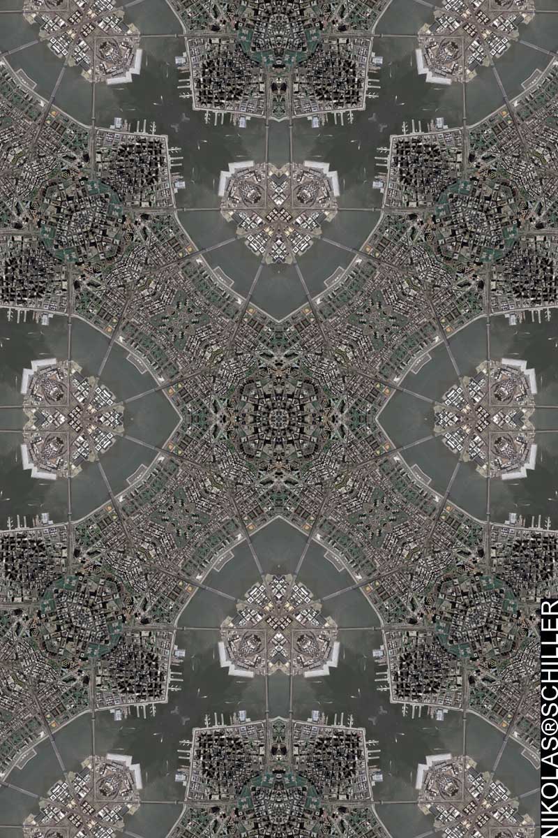
This map shows the Manhattan Bridge and the Brooklyn Bridge, as well as a tiny portion of Brooklyn and a larger portion of Manhattan’s Lower East Side. I tried a few different Quilt projection shapes and finally settled on using the Diamond Quilt Projection because I like the way the bridges create a square box within the diamond layout. I have made a derivative tessellation of this map, but I think I’m going to use some of the other imagery first.

View the Google Map of the Manhattan & Brooklyn Bridges.
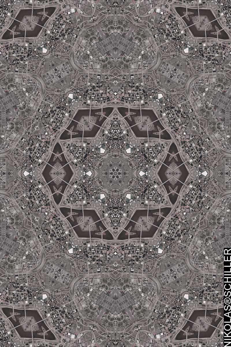
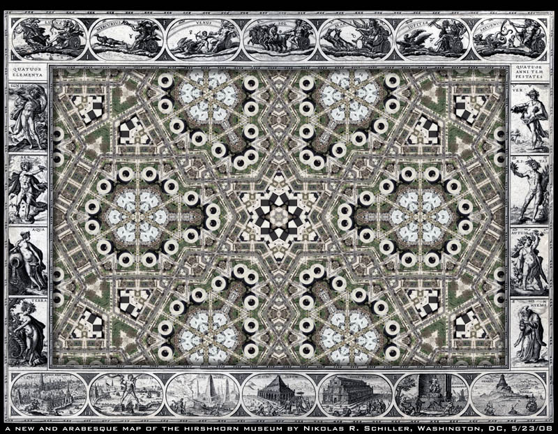
: detail :

View the rest of the map’s close-up details:

+ MORE


A New & Arabesque Map of the Hirshhorn Museum & Sculpture Garden
|| 5/23/2008 || 10:43 am || Comments Off on A New & Arabesque Map of the Hirshhorn Museum & Sculpture Garden || ||


:: saved at 6,480 x 5,040 ::

To celebrate the new procedure I decided to get around to editing the Library of Congress‘ copy of Willem Janszoon Blaeu‘s Nova totius terrarum orbis geographica ac hydrographica tabula, which was published in Amsterdam in 1606. I removed the original map from the center and kept the decorative border similar to Nova et Accvratissima Totivs Terrarvm Orbis Tabvla, A New Map of the Terraqueous Globe : according to the the Ancient discoveries and most general Divisions of Geospatial Art, America as a Cloverleaf, and A New And Accurate Map of the World by John Speed. However, unlike the previous antique map mash-ups, which usually feature the earth laid out in two hemispheres, this map uses a rectangular space (Mercator?). The beauty of this open layout is that I can place any of my previously made maps inside of this 402-year-old template.

A common naming practice I’ve noticed in old map is the use of “New & Accurate” and since I like to play around with words, I changed Accurate to Arabesque to create a visual pun. The source map was about 6,500 pixels wide, I underlaid a rotated 9,000 x 6,000 copy of Hirshhorn Quilt to fit perfectly in the center of the new map. I think it would be fun to actually hand-color the engravings on this map to match other copies of this map which have the various figures colored in. The LOC’s copy is uncolored which means that its actually easier to add color to it than if it were already colored because pigment matching is not needed.


: detail of the planet Goddess Venus :

Across the top (left to right) you have the planet gods:

Drawn within each of these engravings are the signs of the Zodiac that the planets rule:

Below I dissect the rest of the border of the map:

+ MORE


The Daily Render By
A Digital Scrapbook for the Past, Present, and Future.

©2004-2026 Nikolas R. Schiller - Former Colonist of the District of Columbia - Privacy Policy - Fair Use - RSS - Contact


::LAST 51 POSTS::

Fair Use


53 queries. 3.761 seconds.
Powered by WordPress

Photo by Charlie McCormick
Hello! Thanks for stopping by! My name is Nikolas Schiller. I am an American citizen currently living in New York City and working remotely to support structural change in Washington, DC.

This blog is my online repository of what I have created or found online since May of 2004. I've been on hiatus since 2018 but plan on contributing more content in the not so distant future.

If you have any questions or comments, please contact:

If you would like to use content found here, please consult my Fair Use page.

::THE QUILT PROJECTION::

Square
Square

Diamond
diamond

Hexagon
hexagon

Octagon
octagon

Dodecagon
Dodecagon

Beyond
beyond

::OTHER PROJECTIONS::

The Lenz Project
Lenz

Mandala Project
Mandala

The Star Series


Abstract Series
abstract

Memory Series
Memory

Mother Earth Series
Mother Earth

Misc Renderings
Misc

::POPULAR MAPS::

- The Los Angeles Interchanges Series
- The Lost Series
- Terra Fermi
- Antique Map Mashups
- Google StreetView I.E.D.
- LOLmaps
- The Inaugural Map
- The Shanghai Map
- Ball of Destruction
- The Lenz Project - Maps at the Library of Congress
- Winner of the Everywhere Man Award

::MONTHLY ARCHIVES::


@NikolasSchiller

::LOCATIONS & CATEGORIES::

  • 2004 Elections (2)
  • 2008 Elections (35)
  • 2014 Elections (4)
  • 2016 Elections (2)
  • ACLU (3)
  • Activism (287)
  • Adbusters (13)
  • Advertisements (33)
  • aerial photography (19)
  • Analysis (31)
  • Animals (30)
  • animated gif (7)
  • Animation (25)
  • Antique (104)
  • Apple (1)
  • Arabic (17)
  • Architectural Archeology (9)
  • Artomatic (25)
  • Astronomy (15)
  • Astrophotography (9)
  • Audio (2)
  • Awards (3)
  • Backpacking (2)
  • banner graphics (5)
  • Beat Google to the Map (56)
  • bicycle (23)
  • Birds-Eye View (5)
  • Blaeu (10)
  • Book Covers (7)
  • Bridge (10)
  • Building (15)
  • calendar (28)
  • calligraphy (6)
  • Capital (61)
  • Cars (18)
  • Cartography (74)
  • Cartoon (9)
  • Celestial (31)
  • Censorship (32)
  • Chinese (7)
  • Chronicling America (34)
  • Classroom (5)
  • Clothing (12)
  • Commentary (76)
  • Commissioned (27)
  • Credit Cards (3)
  • Crime (12)
  • Cyrillic Alphabet (1)
  • DAILY LINKS (30)
  • Dance (2)
  • DC History (93)
  • Design (102)
  • Digital Scrap (5)
  • Election (11)
  • ESA (3)
  • Facebook (19)
  • Fantasy (3)
  • Fashion (23)
  • Fast Food (2)
  • FBI (7)
  • Flag (15)
  • flickr (4)
  • Found Map (56)
  • French (9)
  • Gallery (54)
  • Gardening (25)
  • General (256)
  • George Bush (12)
  • GIS (69)
  • GMO Labeling (4)
  • Google (31)
  • Google AdSense (4)
  • Google AdWords (3)
  • Google Earth (28)
  • Google Maps (47)
  • Google Reader (4)
  • Google Streetview (8)
  • GPS (7)
  • Graffiti (5)
  • Greek (4)
  • Green (72)
  • Green Party (18)
  • Healthcare (15)
  • Highway (35)
  • Hiking (2)
  • Hipster (2)
  • history (151)
  • Holidays (10)
  • House Party (2)
  • Hubble Telescope (2)
  • Humor (88)
  • In The News (88)
  • Insects (2)
  • Interactive (74)
  • Interiors (4)
  • IP Trace (28)
  • Latin (22)
  • Law (15)
  • Lecture (11)
  • Legislation (19)
  • Library (21)
  • Library of Congress (66)
  • Location (1,018)
  • LOLMaps (3)
  • Mass Transit (6)
  • Memorandum (2)
  • meta-data (32)
  • Mobile Phone Applications (1)
  • Movie (3)
  • MrSID (4)
  • MSN (5)
  • Museum (5)
  • Music (48)
  • MySpace (6)
  • NASA (10)
  • National Archives (3)
  • News (182)
  • Obituary (2)
  • Oil (4)
  • Ornithology (4)
  • orthophotography (4)
  • OSCE (16)
  • Photography (134)
  • Poetry (18)
  • Portuguese (1)
  • postmodern (8)
  • QR code (9)
  • QTVR (4)
  • Radio (3)
  • Renderings (675)
  • RSS (3)
  • Seasons (12)
  • Sold (40)
  • Spanish (7)
  • Speech (5)
  • Sports (1)
  • Stadium (40)
  • statehood (94)
  • Statistics (2)
  • Stellarium (4)
  • Stereogram (1)
  • Street (21)
  • Street Art (10)
  • Submissions (5)
  • Tattoo (2)
  • Testimony (2)
  • time-lapse (19)
  • Torture (3)
  • Transportation (6)
  • TV (23)
  • Twitter (5)
  • University (41)
  • Update (24)
  • Vegetarianism (2)
  • Video (49)
  • Vimeo (18)
  • visualization (36)
  • Washington Critic (2)
  • Weather (19)
  • Web Crawler (9)
  • Wikipedia (14)
  • Wordpress (4)
  • Wordpress Upgrade (2)
  • World Wind (3)
  • Yahoo (6)
  • YouTube (113)
  • Zodiac (23)


  • thank you,
    come again!