1 / 212
The Daily Render

by

A Digital Scrapbook for the Past, Present, and Future


| FRONT PAGE | GEOSPATIAL ART | DC HISTORY | NEWS | COLONIST | FOUND MAPS | FRACTALS | PHOTOGRAPHY | ANTIQUE | DESIGN | VIDEO | BLOGROLL | PRICE LIST | RANDOM | CONTACT |

|| 10/29/2009 || 4:07 pm || + Render A Comment || ||
Randle Highlands VS Fort Dupont [Antique Overlay of an Anacostia Alternative Future]

Screen grab from Google Earth showing the location of Randle Highlands

Image links to the KMZ file for Google Earth

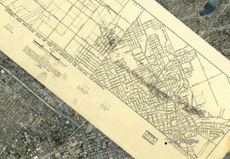
The other day I was canvassing the Library of Congress’ Chronicling America newspaper collection and came across this advertisement that was published on May 27th, 1910 in the Washington Times. It shows development plans for Randle Highlands, a neighborhood in Southeast, Washington, DC. I was curious about the results of the newspaper ad. As in, how much has the map changed in the last 99 years? Surprisingly, not too much. Most of the land was developed to plan, except for one large chunk of the land that remains “undeveloped” to this day: Fort Dupont Park.

The National Park Service website says:

This particular fort had six sides, each 100 feet long, protected by a deep moat and trees felled side-by-side with branches pointing outward. It was named for Flag Officer Samuel F. du Pont, who commanded the naval victory at Port Royal, South Carolina, in November 1861.

Although its garrison and guns never saw battle, Fort Dupont served as a lifeline of freedom. Runaway slaves found safety here before moving on to join the growing community of “contrabands” in Washington. The barracks and guns are gone, but the fort’s earthworks can still be traced near the picnic area on Alabama Avenue.

In the 1930s, the National Capital Planning Commission acquired the old fort and surrounding land for recreation. An 18-hole golf course was constructed. As the city grew, golf gave way in 1970 to the sports complex along Ely Place that now includes tennis and basketball courts, athletic fields, and a softball diamond. An indoor ice rink offers skating all winter. Where once the Civil War fort looked out over farmlands, city dwellers now grow vegetables in community garden plots.

This advertisement was printed 20 years before the National Capital Planning Commission changed the future of this neighborhood. I wonder what it would be like today if it wasn’t a park? Umm, I mean golf course. I was able to line up the old map with the contemporary imagery and by adjusting the transparency in Google Earth you can see how much has been developed. Click here to download the KMZ file for Google Earth


Screen grab from Google Earth showing the location of present day Fort Dupont Park

Image links to Google Maps


Transcription below:

+ MORE


|| 4/8/2008 || 4:52 pm || Comments Off || ||
ABSOLUT STATEHOOD

Screen grab links to .kmz file for Google Earth

A geovisual response to an LA Times blog entry showing mostly isolationist responses to an alternative history map of North America by Absolut Vodka.

This interactive map for Google Earth shows the familiar Absolut Vodka bottle labeled “Absolut Statehood” and placed inside of the original boundaries of the District of Columbia. These boundaries existed until 1847 after the residents of Virginia voted to cede back the portion of the District of Columbia that was west of the Potomac River.

Absolut Statehood represents the cartographic notion that the nation’s capital can become America’s 51st state*. Today there are over 550,000 American citizens living in the nation’s capital that are being denied the fundamental right of representation in Congress. This ongoing human rights violation currently practiced by the government of the United States has been denounced by the United Nations, the Organization of American States, and the Organization for Security and Cooperation in Europe. The United States is the only country in the industrialized world that forbids the residents of it’s capital city the right to elect representatives to their national legislature.

+ MORE


|| 2/27/2008 || 7:17 am || Comments Off || ||
Featured on-line with the Maps exhibition at the Walters Museum

Screen grab showing a small detail of a Concentric Quilt

Starting in mid-November I’ve been volunteering my time with the Walters Museum‘s upcoming exhibition. They have a small technology center (4 iMacs) in their cafeteria which I was given the opportunity to review. I look forward to going to the opening later this month!!

The Walters Museum has also included a layer for Google Earth that I produced for the exhibit. You can download the layer here or here.


|| 1/6/2008 || 2:09 pm || Comments Off || ||
Oil Wells in Los Angeles 103 years ago [One Slick Overlay]

Links to 2.5mb KMZ file for Google Earth
Were the fingerprints dipped in oil too?

The other day I was hunting for maps of Baltimore and stumbled on to the map above (published in Baltimore). It was last prominently featured in the Library of Congress’ “Los Angeles Mapped” on-line exhibition. The map shows downtown Los Angeles with little black dots showing the locations of all the oil wells that existed in 1905.

I wonder how many of the old oil derricks still exist today? I also wonder if people living where the oil wells were constructed own the mineral rights for their property? A few years back I remember looking into purchasing cheap land in Wyoming and one of the stipulations on the land was that the owner would not own the mineral rights below the surface of the earth. Does this exist in present day Los Angeles? Could someone living in Los Angeles today dig a little deeper and find a new source of oil in their backyard?

For more information about this antique map, visit the Library of Congress website. Below is a secondary screen grab showing the area around Dodgers Stadium. It should be noted that the overlay does line up 100% on Google Earth, but close enough to show a change in the built environment.

+ MORE


|| 12/9/2007 || 2:30 am || 1 Comment Rendered || ||
Within Sight of the White House [Overlay of Hooker's Division]

[image links to .kmz file]
Google Earth Screen Shot of the Antique Overlay

One of the maps I recently downloaded was from a newspaper clipping showing the area near the White House. With 50 Saloons and 109 Bawdy-Houses the map was drawn to highlight business owners who were paying Federal taxes but not DC taxes. Of importance is how nearly all but four of the business owners were female. Were they not paying taxes because they were disenfranchised? Women’s suffrage didn’t come for another 30 years with the passage of the 19th Amendment. By taking the map and importing it into Google Earth, I was able to arrange it so that the buildings line up with minimal distortion. It’s not a perfect map, but it is truly an interesting glimpse into downtown Washington, DC in the 1890′s.

Today most of the buildings are all gone. There are some exceptions, like City Hall (Central Powerhouse) and the Old Post Office, which is written as the “New Post Office” on the map. In the place of the 109 Bawdy-Houses and 50 Saloons was the creation of Federal Triangle. Ohio Ave- gone, DC’s entertainment center, gone as well. Later built, on the year of my birth, was Freedom Plaza which was designed to look like L’Enfant’s map no less. By adjusting the antique map’s transparency you can see a approximately 117 years of development. From brothel to federal, what a strange entity time is.

Transcription:

+ MORE


|| 11/28/2007 || 10:27 pm || Comments Off || ||
(Mecca) is now Makkah

On August 12th, 2007 I took this screenshot for my blog entry related to the Astro-theological overlays for Google Earth. The project overlaid the zodiac on locations of religious importance: Vatican City, Mecca, and Jerusalem.

Today I discovered that that the names for the locations have changed in Google Earth.

note: the Kaaba is in the lower right-hand corner

My entire life I have always spelled it the city as Mecca. I wonder when this was changed? Should I change my spellings? Some day I would like to visit the holy city of Makkah :-)


Related Mecca Entries:

+ MORE


|| 8/15/2007 || 2:27 pm || Comments Off || ||
Interchangable Earth

Click the image below to download the .kmz file [7.8 mb] for Google Earth:

Screen grab of Interchangable Earth by Nikolas Schiller

Using the center of 710 & 405 Quilt, which is in the Los Angeles Interchanges series, I constructed this beautiful globe.

Continue reading:

+ MORE


|| 8/14/2007 || 7:13 am || Comments Off || ||
Terra Fermi

Click the image below to download the .kmz file [14.3 mb] for Google Earth:

Terra Ferma means “firm land” or “solid ground” and has been used to describe the conquest of new lands since antiquity.
Terra Fermi is the Enrico Fermi Nuclear Reactor Quilt mapped on to the surface of the earth.
A fitting name for a dangerously beautiful new world.

Continue reading:

+ MORE


|| 8/13/2007 || 2:31 pm || Comments Off || ||
Adams Morgan Earth

Click on the image below to download the .kmz file [11 mb] for Google Earth:

I am quite impressed with this creation. This Interactive Globe for Google Earth features tessellated aerial photography of the Adams Morgan neighborhood of Washington, DC.

Continue reading:

+ MORE


|| 8/12/2007 || 12:14 pm || Comments Off || ||
The Astro-Theological Overlays for Google Earth

Click on the image below to download the .kmz file [888 Kb] for Google Earth:

Instead of just wrapping the Astrological Calendar from 1544 around the earth, today I decided to place the calendar alongside the 3 holy locations of Catholicism, Christianity, Islam, and Judaism. This geographic juxtaposition of pagan symbolism with established religion makes this series of overlays one of the more interesting cartographic creations I’ve ever made.

Continue reading:

+ MORE


The Daily Render By
A Digital Scrapbook for the Past, Present, and Future.

©2004-2010 Nikolas R. Schiller - Colonist of the District of Columbia - Privacy Policy - Fair Use - RSS - Contact


1 / 212


Photo by Charlie McCormick
Nikolas Schiller is a 29-year-old cartographer, consultant, digital artist, researcher, photographer, civil rights activist, and blogger living in America's last continental colony, Washington, DC. If you have any questions or comments, please contact:

+ Facebook
+ Twitter
+ YouTube
+ MySpace
+ Google
+ Vimeo

::SUBSCRIBE::

I am taking a brief break from daily blog postings. Please subscribe to be notified when I resume!

::ARCHIVES BY YEAR::

+ 2010
+ 2009
+ 2008
+ 2007
+ 2006
+ 2005
+ 2004


::RENDERS BY YEAR::

+ 95 in 2008
+ 305 in 2007
+ 213 in 2006
+ 122 in 2005
+ 106 in 2004

::THE QUILT PROJECTION::

Square
Square

Diamond
diamond

Hexagon
hexagon

Octagon
octagon

Dodecagon
Dodecagon

Beyond
beyond

::OTHER PROJECTIONS::

The Lenz Project
Lenz

Mandala Project
Mandala

The Star Series


Abstract Series
abstract

Memory Series
Memory

Mother Earth Series
Mother Earth

Misc Renderings
Misc

::SORTA POPULAR MAPS::

- The Los Angeles Interchanges Series
- The Lost Series
- Terra Fermi
- Antique Map Mashups
- Google StreetView I.E.D.
- LOLmaps
- The Inaugural Map
- The Shanghai Map
- Ball of Destruction
- The Lenz Project - Maps at the Library of Congress
- Winner of the Everywhere Man Award

::MONTHLY ARCHIVES::

::LOCATIONS & CATEGORIES::

::LAST 51 POSTS::

Fair Use


15 queries. 1.474 seconds.
Powered by WordPress

::SUPPORT::

pay with paypal

:: LAST VISITORS ::