The Daily Render

by

A Digital Scrapbook for the Past, Present, and Future

| FRONT PAGE | GEOSPATIAL ART | DC HISTORY / TIMELINE | NEWS | COLONIST | FOUND MAPS | FRACTALS |
| PHOTOGRAPHY | ANTIQUE | DESIGN | VIDEO | | CONTACT |

2010 Cartographic Calendar [Black & White Edition]
|| 11/29/2009 || 9:47 am || 2 Comments Rendered || ||

Front cover of the Black & White Edition of the 2010 Cartographic Calendar by Nikolas Schiller

This unique wall calendar contains 12 maps of the Washington originally published in the newspapers of the District of Columbia between 1887 and 1909. There are two editions of the calendar available: one with the original black & white scans (below) and the other with colorized maps. Each calendar is on sale for $25 + shipping until January 31st, 2009.

Below are the pages from each month of the Black & White Edition of the 2010 Cartographic Calendar:

+ MORE


A Projected Relief Park Map of the United States – The Washington Times, March 28, 1897
|| 11/26/2009 || 3:54 pm || 1 Comment Rendered || ||

Yesterday I found this unique map that was published by the Washington Times on Sunday, March 28th, 1897 in the Library of Congress / National Endowment for the Humanities “Chronicling America Collection.” Its rather amazing how this portion of the National Mall was ultimately developed! Where would Alaska & Hawaii have been added? With today being Thanksgiving, I am giving thanks to the fact that some maps were never made.


Scans & transcription of the article below:

+ MORE


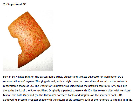
My Accidental Geography Submission “Gingerbread DC” Was Featured Today on StrangeMaps
|| 11/23/2009 || 7:12 pm || + Render A Comment || ||

Screen grab from the blog Strange Maps by Frank Jacobs of the District of Columbia made out of Gingerbread

+ MORE


whereyouare / whereiam@ – A Satircal Election Map of Maine’s Vote on Same-Sex Marriage
|| 11/8/2009 || 1:46 pm || 1 Comment Rendered || ||

Original Map by Julie Harris & Eric Zelz of the Bangor Daily News [PDF]

The evening after Maine’s election results came in I was asked to help coordinate the sound system for an impromptu rally at Dupont Circle. During one of the speeches, I remember hearing someone mention that the ballot should never be used to let the majority of population impose it’s will on a minority population. Being that there are far fewer gay couples in Maine (or most states for that matter) than heterosexual couples; the point stood out in my mind.

Its an example of the “tyranny of the majority,” at the ballot box. The fundamental inalienable principles of equality, all men being created equal, and the pursuit of happiness are the foundation of American democracy and when those words were written the largest city in America was Philadelphia, with 28,000 citizens and the rest of the American population was mostly rural. Yet in the 200+ years since, the rural / urban divide has only grown more stark as some states contain few large centers of population. Paradoxically, its in these cities where the most social interaction & social education takes place. It’s in cities where people are more likely to see same-sex couples in their daily lives and possibly have same sex-couples as their friends, and thereby be more apt to see same-sex couples from a different perspective that is not based on prejudice towards The Other.

The modified map [pdf] above was originally found on the Bangor Daily News website. It shows how the state of Maine voted on the question of same-sex marriage. Voters were given the opportunity to Vote Yes and repeal the recently-passed same-sex marriage law or Vote No to keep it in place.

To remix this map, I first inverted the color scheme, which surprisingly yielded a pink color for the counties which voted 65% or greater to repeal the law. Ironically, its a color I personally associate with those who voted No. I then added my own typographical critique to the map. I created a pink square and placed in an unpopulated rural location and added the words “whereyouare,” in large font and in the southern portion of the map, in smaller font size, I added the words “whereiam@” above Maine’s largest city, Portland.

The justification for this subtle addition was to highlight the nature of the urban / rural divide. Portland, for example, voted 73.5% to not repeal the same-sex marriage law, so I placed “whereiam@” nearby to show where my vote would have been. Most rural areas overwhelmingly supported the removal of equal rights for their fellow citizens, so I placed the pink square in an area that doesn’t even an election precinct.


Randle Highlands VS Fort Dupont [Antique Overlay of an Anacostia Alternative Future]
|| 10/29/2009 || 4:07 pm || + Render A Comment || ||

Screen grab from Google Earth showing the location of Randle Highlands

Image links to the KMZ file for Google Earth

The other day I was canvassing the Library of Congress’ Chronicling America newspaper collection and came across this advertisement that was published on May 27th, 1910 in the Washington Times. It shows development plans for Randle Highlands, a neighborhood in Southeast, Washington, DC. I was curious about the results of the newspaper ad. As in, how much has the map changed in the last 99 years? Surprisingly, not too much. Most of the land was developed to plan, except for one large chunk of the land that remains “undeveloped” to this day: Fort Dupont Park.

The National Park Service website says:

This particular fort had six sides, each 100 feet long, protected by a deep moat and trees felled side-by-side with branches pointing outward. It was named for Flag Officer Samuel F. du Pont, who commanded the naval victory at Port Royal, South Carolina, in November 1861.

Although its garrison and guns never saw battle, Fort Dupont served as a lifeline of freedom. Runaway slaves found safety here before moving on to join the growing community of “contrabands” in Washington. The barracks and guns are gone, but the fort’s earthworks can still be traced near the picnic area on Alabama Avenue.

In the 1930s, the National Capital Planning Commission acquired the old fort and surrounding land for recreation. An 18-hole golf course was constructed. As the city grew, golf gave way in 1970 to the sports complex along Ely Place that now includes tennis and basketball courts, athletic fields, and a softball diamond. An indoor ice rink offers skating all winter. Where once the Civil War fort looked out over farmlands, city dwellers now grow vegetables in community garden plots.

This advertisement was printed 20 years before the National Capital Planning Commission changed the future of this neighborhood. I wonder what it would be like today if it wasn’t a park? Umm, I mean golf course. I was able to line up the old map with the contemporary imagery and by adjusting the transparency in Google Earth you can see how much has been developed. Click here to download the KMZ file for Google Earth


Screen grab from Google Earth showing the location of present day Fort Dupont Park

Image links to Google Maps


Transcription below:

+ MORE


Map of Westminster Street NW in Washington, DC from 1921
|| 9/27/2009 || 4:46 pm || 1 Comment Rendered || ||

Last year I published Then & Now Birds-Eye Views of the Westminster Neighborhood in Washington, DC [1884 & 2005] and earlier today I came across some new maps of the street I’ve lived on for the last 5 years. This map comes from the 1921 edition of Baist’s real estate atlas of surveys of Washington, District of Columbia. It shows the neighborhood pretty much as it is today except for the neighborhood playground that currently sits where houses 193-196 used to be and some of the stables & garages people had constructed in their backyards have been removed.

Below is the citation from the Library of Congress entry:

+ MORE


Violent Crime In My Neighborhood Has Increased Over 100% in the Last Year
|| 9/22/2009 || 1:43 pm || 1 Comment Rendered || ||

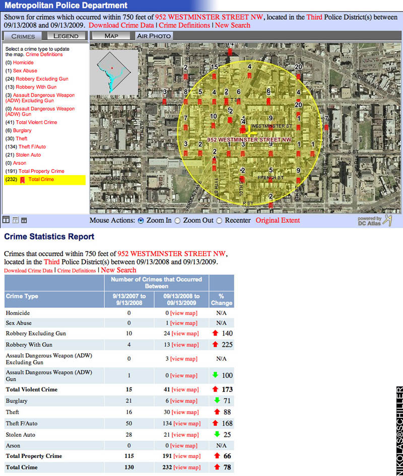
Last week my City Councilmember, Jim Graham, sent an e-mail about the drop in crime over the last 30 days to my neighborhood association listserv and included various local government officials like the DC Police Chief, Cathy Lanier. The e-mail featured two graphs of data from DC’s Crime Map that covered the police service area of my neighborhood and showed the crime statistics of August to September of 2008 compared to August to September of 2009. What the graph lacked, however, was the hyperlocal angle of the crime taking place in the immediate vicinity of the block that we live on and the larger picture showing the other 11 months of crime data.

As a two-time victim of violent crime last year in my neighborhood, on my front doorstep & at the end of the block, I was fully aware that the data in the graphs included me, so I felt compelled to use the very same tool my councilmember used to analyze the extent of the crimes that have recently taken place. The result genuinely stunned me and I proceeded to respond to his e-mail (text below) with the two maps (above & below) that show the various crimes that have taken place in my neighborhood.

+ MORE


The Pentagon Timelapse Animated GIF (2001-2005)
|| 9/1/2009 || 5:00 pm || + Render A Comment || ||

Still frame from The Pentagon Timelapse Animated GIF featuring USGS aerial photography from 2005Still frame from The Pentagon Timelapse Animated GIF featuring USGS aerial photography from 2005
Click the image above to watch the animation

Last night I was going through one of my external hard drives and rediscovered a cache of “old” satellite imagery. I rarely publish any entries that use satellite imagery due to copyright issues because, generally speaking, the company that owns the satellite also owns all the pixels and this prevents me from legally creating derivative works. Today, however, I decided to test the boundaries with this legacy satellite imagery of the Pentagon and feel that this creation is protected under the fair use doctrine of US copyright law. You can always contact GeoEye if you are interested in purchasing satellite imagery from the IKONOS satellite.

The Animated GIF below features 9 frames consisting of 7 satellite images from the IKONOS Satellite (2001-2002) and two public domain aerial photographs from the USGS (2002 & 2005). It begins with satellite imagery taken four days before 9/11/01 and ends with a USGS aerial photograph taken in September 2005. The frames in between show the aftermath and the subsequent rebuilding of the Pentagon. I did my best to line up the building in my image editing program, but it’s not 100% perfect due to the angle in which some of the imagery was taken.


I have chosen to place the The Pentagon Timelapse Animated GIF “below the fold” so that visitors to the front page of this website are not downloading the somewhat large file. Please be patient while it downloads……

+ MORE


Participating in my Monthly Maps Sale in 3 Easy Steps
|| 8/26/2009 || 11:08 pm || + Render A Comment || ||

Washington Monument Quilt by Nikolas Schiller - The first Monthly Map

Starting earlier this month those who are subscribed to my listserv were given the opportunity to purchase a map at the reasonable price of $100. I felt this was a great way to cheaply obtain the different maps I have created over the years. Since I have hundreds of maps to choose from, this monthly opportunity will last for years and ultimately become a great way to collect my maps.

Previously I used to point people to my ImageKind Store, but I wasn’t pleased with some of the cheap papers the maps were printed on, and have chosen to remove the middle man, so to speak, and have all the map purchases go directly through me. This way I can control the materials the maps are printed on, personally sign each map, and ensure the quality for each map that is produced.

For the month of August, the first Monthly Map, I chose was Washington Monument Quilt (above), which I first rendered on January 31st, 2006. Since the area around the Washington Monument was redacted in the 2005 USGS aerial photography, I felt it was a worthwhile piece to start with.

After sending out my initial e-mail about the offering, I had a friend contact me about purchasing the map and decided to document some of the steps involved in the process of ordering the maps through me….


Washington Monument Quilt by Nikolas Schiller in a shipping tube

Photo of the tube the map is shipped inside of.

Step One – Payment

You can either contact me about sending cash or a check or you can quickly & easily pay the $100 by credit card on my PayPal merchant account page. After I receive the payment, I will need your mailing address if you want the map mailed to you. If you live in Washington, DC, I can either mail it to you or meet you in person and hand-deliver the map. I’ve found it easiest to go through PayPal because it’s quick and safe.


Washington Monument Quilt by Nikolas Schiller in a shipping tube

Photo of the rolled up map next to the shipping tube

Step Two – Printing

After I receive payment, I send the map to the printer. For the time being, my Monthly Map Sale is featuring 30″ x 20″ prints on Kodak PerfectTouch Paper. Throughout the last 5 years I’ve had the best results on this medium, both in quality of colors and durability of the paper. It’s also the same medium I used when I donated 8 maps to the Library of Congress in 2006. In about 3 days or less, I receive confirmation that the map has been printed and is in transit to me or you.


Washington Monument Quilt by Nikolas Schiller in a shipping tube

Photo of unrolled map of Washington Monument Quilt

Step Three – Shipping

I can have the map shipped directly to you as well (without signature, date, or label) for faster turnaround or I can have it shipped to my house. After the map arrives, I remove it from the shipping tube (above), carefully flip it over, label the name of the map, label the date it was originally rendered, label the date it was printed, and sign the map (below).

After this, I roll the map back up into the tube, add a little extra padding to ensure the map will not be damaged, then I bring it to the post office. Three days later it should be delivered to your mailbox. Or if the map is purchased locally, we can meet up and exchange the map in person.


Washington Monument Quilt by Nikolas Schiller in a shipping tube

Photo of the label, date, and partial signature

THATS IT! I think the whole process is pretty simple. In all this process takes about one or two weeks depending on the speed at which the payment is received and how long it takes for the map to be printed and shipped.

I think the hardest part of it all will be choosing which map to offer each month! Please contact me if you are interested in purchasing this month’s map or have suggestions for future Monthly Map offerings.



The Daily Render By
A Digital Scrapbook for the Past, Present, and Future.

©2004-2023 Nikolas R. Schiller - Colonist of the District of Columbia - Privacy Policy - Fair Use - RSS - Contact


::LAST 51 POSTS::

Fair Use


54 queries. 1.272 seconds.
Powered by WordPress

Photo by Charlie McCormick
Nikolas Schiller is a second-class American citizen living in America's last colony, Washington, DC. This blog is my on-line repository of what I have created or found on-line since May of 2004. If you have any questions or comments, please contact:

If you would like to use content found here, please consult my Fair Use page.

::THE QUILT PROJECTION::

Square
Square

Diamond
diamond

Hexagon
hexagon

Octagon
octagon

Dodecagon
Dodecagon

Beyond
beyond

::OTHER PROJECTIONS::

The Lenz Project
Lenz

Mandala Project
Mandala

The Star Series


Abstract Series
abstract

Memory Series
Memory

Mother Earth Series
Mother Earth

Misc Renderings
Misc

::POPULAR MAPS::

- The Los Angeles Interchanges Series
- The Lost Series
- Terra Fermi
- Antique Map Mashups
- Google StreetView I.E.D.
- LOLmaps
- The Inaugural Map
- The Shanghai Map
- Ball of Destruction
- The Lenz Project - Maps at the Library of Congress
- Winner of the Everywhere Man Award

::MONTHLY ARCHIVES::


::LOCATIONS & CATEGORIES::

  • 2004 Elections (2)
  • 2008 Elections (35)
  • 2014 Elections (4)
  • 2016 Elections (2)
  • ACLU (3)
  • Activism (287)
  • Adbusters (13)
  • Advertisements (33)
  • aerial photography (19)
  • Analysis (31)
  • Animals (30)
  • animated gif (7)
  • Animation (25)
  • Antique (104)
  • Apple (1)
  • Arabic (17)
  • Architectural Archeology (9)
  • Artomatic (25)
  • Astronomy (15)
  • Astrophotography (9)
  • Audio (2)
  • Awards (3)
  • Backpacking (2)
  • banner graphics (5)
  • Beat Google to the Map (56)
  • bicycle (23)
  • Birds-Eye View (5)
  • Blaeu (10)
  • Book Covers (7)
  • Bridge (10)
  • Building (15)
  • calendar (28)
  • calligraphy (6)
  • Capital (61)
  • Cars (18)
  • Cartography (74)
  • Cartoon (9)
  • Celestial (31)
  • Censorship (32)
  • Chinese (7)
  • Chronicling America (34)
  • Classroom (5)
  • Clothing (12)
  • Commentary (76)
  • Commissioned (27)
  • Credit Cards (3)
  • Crime (12)
  • Cyrillic Alphabet (1)
  • DAILY LINKS (30)
  • Dance (2)
  • DC History (93)
  • Design (102)
  • Digital Scrap (5)
  • Election (11)
  • ESA (3)
  • Facebook (19)
  • Fantasy (3)
  • Fashion (23)
  • Fast Food (2)
  • FBI (7)
  • Flag (15)
  • flickr (4)
  • Found Map (56)
  • French (9)
  • Gallery (54)
  • Gardening (25)
  • General (256)
  • George Bush (12)
  • GIS (69)
  • GMO Labeling (4)
  • Google (31)
  • Google AdSense (4)
  • Google AdWords (3)
  • Google Earth (28)
  • Google Maps (47)
  • Google Reader (4)
  • Google Streetview (8)
  • GPS (7)
  • Graffiti (5)
  • Greek (4)
  • Green (72)
  • Green Party (18)
  • Healthcare (15)
  • Highway (35)
  • Hiking (2)
  • Hipster (2)
  • history (151)
  • Holidays (10)
  • House Party (2)
  • Hubble Telescope (2)
  • Humor (88)
  • In The News (88)
  • Insects (2)
  • Interactive (74)
  • Interiors (4)
  • IP Trace (28)
  • Latin (22)
  • Law (15)
  • Lecture (11)
  • Legislation (19)
  • Library (21)
  • Library of Congress (66)
  • Location (1,018)
  • LOLMaps (3)
  • Mass Transit (6)
  • Memorandum (2)
  • meta-data (32)
  • Mobile Phone Applications (1)
  • Movie (3)
  • MrSID (4)
  • MSN (5)
  • Museum (5)
  • Music (48)
  • MySpace (6)
  • NASA (10)
  • National Archives (3)
  • News (182)
  • Obituary (2)
  • Oil (4)
  • Ornithology (4)
  • orthophotography (4)
  • OSCE (16)
  • Photography (134)
  • Poetry (18)
  • Portuguese (1)
  • postmodern (8)
  • QR code (9)
  • QTVR (4)
  • Radio (3)
  • Renderings (675)
  • RSS (3)
  • Seasons (12)
  • Sold (40)
  • Spanish (7)
  • Speech (5)
  • Sports (1)
  • Stadium (40)
  • statehood (94)
  • Statistics (2)
  • Stellarium (4)
  • Stereogram (1)
  • Street (21)
  • Street Art (10)
  • Submissions (5)
  • Tattoo (2)
  • Testimony (2)
  • time-lapse (19)
  • Torture (3)
  • Transportation (6)
  • TV (23)
  • Twitter (5)
  • University (41)
  • Update (24)
  • Vegetarianism (2)
  • Video (49)
  • Vimeo (18)
  • visualization (36)
  • Washington Critic (2)
  • Weather (19)
  • Web Crawler (9)
  • Wikipedia (14)
  • Wordpress (4)
  • Wordpress Upgrade (2)
  • World Wind (3)
  • Yahoo (6)
  • YouTube (113)
  • Zodiac (23)


  • thank you,
    come again!