The Daily Render

by

A Digital Scrapbook for the Past, Present, and Future

| FRONT PAGE | GEOSPATIAL ART | DC HISTORY / TIMELINE | NEWS | COLONIST | FOUND MAPS | FRACTALS |
| PHOTOGRAPHY | ANTIQUE | DESIGN | VIDEO | | CONTACT |

Thomas Jefferson’s Map of Washington from March 31st, 1791
|| 2/28/2009 || 1:30 pm || + Render A Comment || ||

Map courtesy of the Library of Congress

Throughout the week I watched the Senate debate on the District of Columbia House Voting Rights Act of 2009. This bill (which I’ve written about before in its different forms) will give DC residents a token vote in the House of Representatives, while denying us representation in the Senate. (Taxation Without 2/3’s Representation!!) Thursday afternoon the Senate passed the Act after they also voted to add a bogus amendment written by the National Rifle Association to weaken/remove the District of Columbia’s gun laws. The vote showed clearly that the District of Columbia is still Congress’ little colony and even with the Act’s passage, DC residents are no better off than before, except of course, we’ll be governed by 536 unelected officials, instead of 535. Hurrah for continued tyranny masked as progress!

There were two words I heard over and over again during the Senate debate: Founding Fathers. Thomas Jefferson, the third president of the United States, is revered as one of America’s founding fathers and after looking at his map that he drew in 1791 (and attempting to read his nearly illegible text), I’ve come to the conclusion that the Seat of Government that the Constitution gives Congress exclusive jurisdiction over (Article I, Section 8, Clause 17), is also nearly the same geography that was defined as the National Capital Service Area [link to Google Map] when DC statehood was proposed. This area is basically all the federal government buildings around the National Mall and is what I feel Congress should have exclusive control over. So why was the Seat of Government expanded to include the entire District of Columbia when Jefferson clearly drew a smaller vision 218 years ago? I don’t know, but fixing one of the Founding Father’s faux-pas should involve giving DC residents full equality that citizens of the rest of America receive, which means representation in both the House and the Senate.


Related Colonist Entries:

+ MORE


The Peters Projection advocated on the West Wing television show
|| 2/20/2009 || 1:35 am || Comments Off on The Peters Projection advocated on the West Wing television show || ||

NBC’s The West Wing – Why are we changing maps?? – From season 2 – Episode 16
A fictional group called the “Organization of Cartographers for Social Equality,” pitches President Bartlet’s staff to “aggressively support” legislation mandating every public school in America teach geography using the Peters Projection map.


Read more about the Gall-Peters Projection on Wikipedia. Or check out this trailer. [VIA Press Release from 2001]


The 11 Mile Canyon Dam
|| 12/26/2008 || 10:17 pm || Comments Off on The 11 Mile Canyon Dam || ||

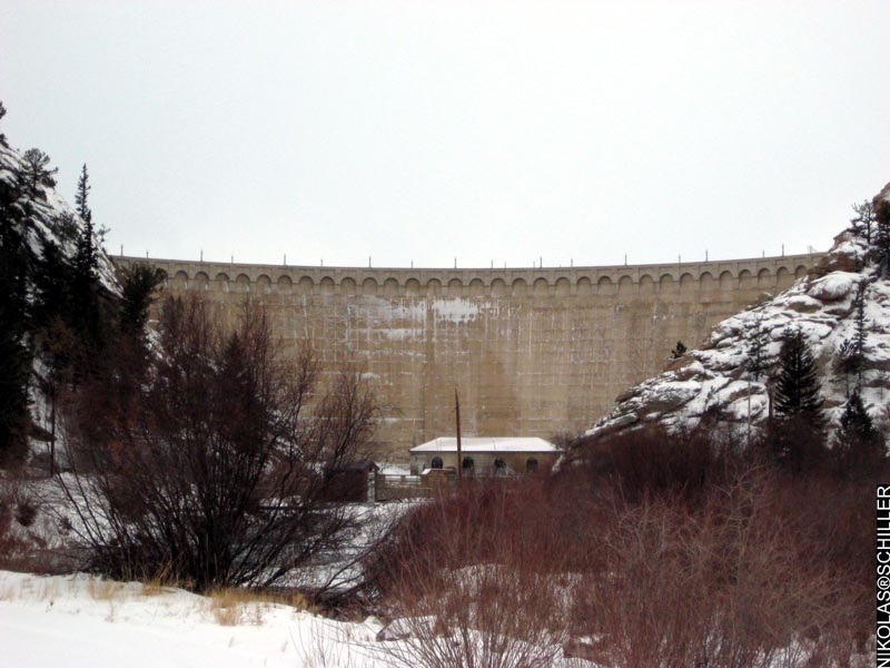
Today we drove up a snow-covered County Road 96 outside of Lake George, Colorado to the 11 Mile Canyon Dam. The photograph above was taken from the edge of the restricted area near the Spillway campground (see map below). It shows the face of the 153 foot tall 11 Mile Canyon Dam that was constructed in 1932. The water from this dam forms the South Platte River, which flows through the city of Denver and supplies a substantial amount of the city’s drinking water from reservoirs further downstream.

+ MORE


[FOUND MAP] New York City: The 51st State
|| 12/24/2008 || 6:34 pm || Comments Off on [FOUND MAP] New York City: The 51st State || ||

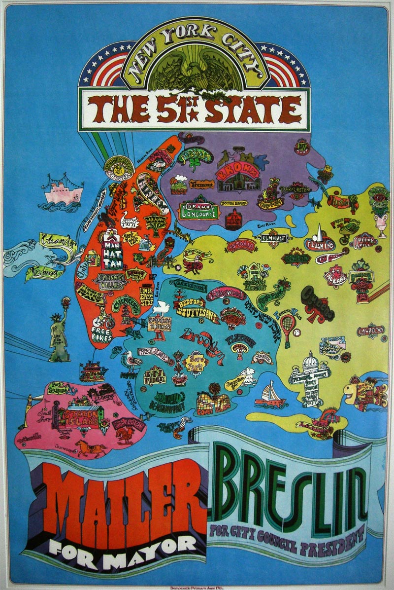
I have rallied for years about having DC become the 51st state in America. Even last week I redesigned the American flag to address my feelings toward this subject. However today I came across this map above that mentions the 51st state and predates the organization of the DC Statehood Movement.

In 1969 author Norman Mailer ran for mayor of New York City and one aspect of his campaign was New York City secession through urban statehood. This lovely map shows all the neighborhoods in each of the boroughs and subtly pokes fun at the current “state” of New York City.

I can’t help but wonder, what if this political option was pursued again? Would New York City residents be interested in having federal funds being directed to the city instead of the rest of the state? Political climate aside, would Americans be more receptive if DC statehood was concurrently offered so that the number states is not an odd number? Or is America just stuck at 50 because its a nice number?

When president-elect Barack Obama assumes office, he’ll be the first black president to live in the same federal district that has a majority black population who can never duplicate the steps in his American Dream. His path to presidency included a path no resident of the nation’s capital can follow- he was a United States senator. Without two senators like every other state, the residents of the nation’s capital, unlike the residents of New York City, are still second-class citizens denied the same equality every other American enjoys. Will Obama be a real leader and address this fundamental flaw in our government?

While the map above proposes the concept of urban statehood, there is also the notion of urban / island balancing worth mentioning. The boroughs themselves are drawn as distinct counties and in some respects their natural geographies create urban islands, like Manhattan & Staten, within the unified state of New York City. President-elect Barack Obama comes from a former island territory, now state, Hawaii, which was brought into the union at nearly the same time as Alaska for balancing purposes. Could urban statehood, like that of Washington, DC or New York City, be balanced with statehood for other American islands, like Guam, Puerto Rico, or the Virgin Islands? Or with the islands having a majority population of non-white people, like their urban counterparts, be a lurking reminder that racism still present in America? Should congressional representation be denied to American citizens simply based upon how their geography happens to be located or politically aligned? Sadly, I think thats what we have today and, to me, its veiled racism defended as normal partisan politics.


Click here to read more about the map and view numerous close-up details.


The American Flag in a 51 Star Configuration with One Star Removed
|| 12/16/2008 || 1:08 am || Comments Off on The American Flag in a 51 Star Configuration with One Star Removed || ||

An American Flag with 51 star configuration with one star removed by Nikolas Schiller

Lately I’ve read a couple articles related to DC becoming America’s 51st state. While I’m wholeheartedly in favor of this prospect, two nights ago I decided to make an American flag showing my frustration with the fact that this route is not currently being pursued.

Above is a static public domain flag I found on WIkipedia by Gunter Küchler that I decided to modify showing what an American flag could look like, but with one star (New Columbia) removed.

Below are the animated versions of the flag that I produced to highlight the lack of the 51st star on America’s flag:

+ MORE


Geospatial art created by exploiting search engine aggregation algorithms
|| 12/10/2008 || 6:22 pm || Comments Off on Geospatial art created by exploiting search engine aggregation algorithms || ||

The other day I noticed that there were literally hundreds of search engine results that contain a fictitious url to a page on my website that didn’t exist. It appears that Internet bots have exploited an issue with search engine aggregation algorithms to trick them into showing a bogus search result for a page that never existed on my website. Throughout the internet there are numerous pages that contain https://nikolasschiller.com/showthread.php?XXXXX and when people clicked on the bogus link they were brought to a 404 page. Last night I created a copy of this website’s splash page and renamed the file showthread.php. Now when people click on the fake link in the fraudulently created search engine result, they are brought to my website’s beautifully abstract splash page. Today I’ve been receiving all sorts of random visitors!


UPDATE – 12/13/08 – I’ve decided to change the page slightly and add the word FAIL to the landing page. The reason for this is because the person landing on the page failed to find what they were looking for.


Found in the Grand Juxtaposition: I am not a terrorist in Tucson
|| 11/20/2008 || 5:09 pm || Comments Off on Found in the Grand Juxtaposition: I am not a terrorist in Tucson || ||

This screen grab from the Grand Juxtaposition and combines the arabic text “I am not a terrorist” with Tucson Quilt.

Related Arabic Entries:

+ MORE


She’s got the sole of the city with SWIMS galoshes
|| 10/31/2008 || 11:51 am || Comments Off on She’s got the sole of the city with SWIMS galoshes || ||

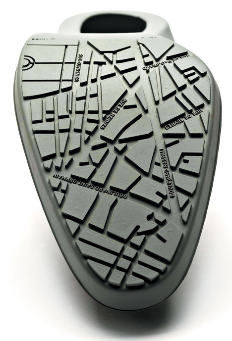
Map of Paris featured on SWIMS City Slipper high heel

I read about these stylish galoshes a little while ago, and saw the map on sole of the shoe, but I couldn’t find a high resolution version that showed the actual map. Yesterday I found it. SWIMS, a Scandinavian company known for making stylish galoshes, incorporates lots of great details both for practical and aesthetic reasons such as:

• Extra traction for slippery surfaces.
• The sole of each CitySlipper has the map of either New York, Paris, or Tokyo.
• Pull on/off grip and the soft siliconpad on the sides makes it very convenient.
• Flexible design to fit almost any heel height and thickness due to flexible material and construction.
• Protection for the delicate leather/suede sole of your shoe and the tip of the shoe against the elements.
• Low-Cut style is for shoes with bows and buckles.


The maps themselves definitely fall into the realm of aesthetics not cartographics, but ya know, I am a big fan of those kind of maps.


Related Fashion Entries:

+ MORE


You’re A Nation!
|| 10/23/2008 || 12:05 pm || 2 Comments Rendered || ||

I was at a house party over the weekend and went to the bathroom to relieve myself. As I was unzipping my fly, I looked up and saw the map in magazine on top of the toilet and an old joke came into my mind: When you go into the bathroom you are an American. When you leave the bathroom, you are an American. What are you in the bathroom? Now the answer to the joke/riddle is funny (if you are in the 5th grade) and simple: European aka You’re a pee’in’ (get it?!)

I’ve been trying to take photographs of found maps with my camera and this one was too funny to pass up. By combining that lame humor with the fact that map in the magazine above shows most of the western hemisphere, I decided to switch out the word “‘peein” and add the word “nation,” hence, “Urination or You’re A Nation!” ….Rimshot…. Talk about taking the piss


Kiss My Art, Just Kiss It
|| 9/26/2008 || 4:05 pm || Comments Off on Kiss My Art, Just Kiss It || ||

A couple weeks ago one of my housemates had some of her friends over for dinner. Near the end of the evening one of guests got out their camera and started taking some random photos. I found the photograph above on their photobucket page and decided to repost it here because it made me smile. On the left is gnome mooning everyone, in the back center is a gallery wrapped 32″x48″ print of Superdome Quilt First Derivative #2, and on the right is musician Sean McArdle. I don’t know why the gnome was making an appearance at the dinner party, but at least he decided to show his sincere disdain for proper decorum by mooning the guests. I’m told not many gnomes are not that nice.

As for the title of this entry, its a play on words of a slogan from a Washington, DC-based car insurance company’s television commercial series. And marginally related, there is an event taking place in San Francisco this weekend called Arse Electronica, which is a play on words for Ars Electronica. Consider this photograph decided to all three :-)


Related Humor:

+ MORE


The Daily Render By
A Digital Scrapbook for the Past, Present, and Future.

©2004-2023 Nikolas R. Schiller - Colonist of the District of Columbia - Privacy Policy - Fair Use - RSS - Contact


::LAST 51 POSTS::

Fair Use


54 queries. 0.768 seconds.
Powered by WordPress

Photo by Charlie McCormick
Nikolas Schiller is a second-class American citizen living in America's last colony, Washington, DC. This blog is my on-line repository of what I have created or found on-line since May of 2004. If you have any questions or comments, please contact:

If you would like to use content found here, please consult my Fair Use page.

::THE QUILT PROJECTION::

Square
Square

Diamond
diamond

Hexagon
hexagon

Octagon
octagon

Dodecagon
Dodecagon

Beyond
beyond

::OTHER PROJECTIONS::

The Lenz Project
Lenz

Mandala Project
Mandala

The Star Series


Abstract Series
abstract

Memory Series
Memory

Mother Earth Series
Mother Earth

Misc Renderings
Misc

::POPULAR MAPS::

- The Los Angeles Interchanges Series
- The Lost Series
- Terra Fermi
- Antique Map Mashups
- Google StreetView I.E.D.
- LOLmaps
- The Inaugural Map
- The Shanghai Map
- Ball of Destruction
- The Lenz Project - Maps at the Library of Congress
- Winner of the Everywhere Man Award

::MONTHLY ARCHIVES::


::LOCATIONS & CATEGORIES::

  • 2004 Elections (2)
  • 2008 Elections (35)
  • 2014 Elections (4)
  • 2016 Elections (2)
  • ACLU (3)
  • Activism (287)
  • Adbusters (13)
  • Advertisements (33)
  • aerial photography (19)
  • Analysis (31)
  • Animals (30)
  • animated gif (7)
  • Animation (25)
  • Antique (104)
  • Apple (1)
  • Arabic (17)
  • Architectural Archeology (9)
  • Artomatic (25)
  • Astronomy (15)
  • Astrophotography (9)
  • Audio (2)
  • Awards (3)
  • Backpacking (2)
  • banner graphics (5)
  • Beat Google to the Map (56)
  • bicycle (23)
  • Birds-Eye View (5)
  • Blaeu (10)
  • Book Covers (7)
  • Bridge (10)
  • Building (15)
  • calendar (28)
  • calligraphy (6)
  • Capital (61)
  • Cars (18)
  • Cartography (74)
  • Cartoon (9)
  • Celestial (31)
  • Censorship (32)
  • Chinese (7)
  • Chronicling America (34)
  • Classroom (5)
  • Clothing (12)
  • Commentary (76)
  • Commissioned (27)
  • Credit Cards (3)
  • Crime (12)
  • Cyrillic Alphabet (1)
  • DAILY LINKS (30)
  • Dance (2)
  • DC History (93)
  • Design (102)
  • Digital Scrap (5)
  • Election (11)
  • ESA (3)
  • Facebook (19)
  • Fantasy (3)
  • Fashion (23)
  • Fast Food (2)
  • FBI (7)
  • Flag (15)
  • flickr (4)
  • Found Map (56)
  • French (9)
  • Gallery (54)
  • Gardening (25)
  • General (256)
  • George Bush (12)
  • GIS (69)
  • GMO Labeling (4)
  • Google (31)
  • Google AdSense (4)
  • Google AdWords (3)
  • Google Earth (28)
  • Google Maps (47)
  • Google Reader (4)
  • Google Streetview (8)
  • GPS (7)
  • Graffiti (5)
  • Greek (4)
  • Green (72)
  • Green Party (18)
  • Healthcare (15)
  • Highway (35)
  • Hiking (2)
  • Hipster (2)
  • history (151)
  • Holidays (10)
  • House Party (2)
  • Hubble Telescope (2)
  • Humor (88)
  • In The News (88)
  • Insects (2)
  • Interactive (74)
  • Interiors (4)
  • IP Trace (28)
  • Latin (22)
  • Law (15)
  • Lecture (11)
  • Legislation (19)
  • Library (21)
  • Library of Congress (66)
  • Location (1,018)
  • LOLMaps (3)
  • Mass Transit (6)
  • Memorandum (2)
  • meta-data (32)
  • Mobile Phone Applications (1)
  • Movie (3)
  • MrSID (4)
  • MSN (5)
  • Museum (5)
  • Music (48)
  • MySpace (6)
  • NASA (10)
  • National Archives (3)
  • News (182)
  • Obituary (2)
  • Oil (4)
  • Ornithology (4)
  • orthophotography (4)
  • OSCE (16)
  • Photography (134)
  • Poetry (18)
  • Portuguese (1)
  • postmodern (8)
  • QR code (9)
  • QTVR (4)
  • Radio (3)
  • Renderings (675)
  • RSS (3)
  • Seasons (12)
  • Sold (40)
  • Spanish (7)
  • Speech (5)
  • Sports (1)
  • Stadium (40)
  • statehood (94)
  • Statistics (2)
  • Stellarium (4)
  • Stereogram (1)
  • Street (21)
  • Street Art (10)
  • Submissions (5)
  • Tattoo (2)
  • Testimony (2)
  • time-lapse (19)
  • Torture (3)
  • Transportation (6)
  • TV (23)
  • Twitter (5)
  • University (41)
  • Update (24)
  • Vegetarianism (2)
  • Video (49)
  • Vimeo (18)
  • visualization (36)
  • Washington Critic (2)
  • Weather (19)
  • Web Crawler (9)
  • Wikipedia (14)
  • Wordpress (4)
  • Wordpress Upgrade (2)
  • World Wind (3)
  • Yahoo (6)
  • YouTube (113)
  • Zodiac (23)


  • thank you,
    come again!