|| 10/30/2009 || 3:51 pm || + Render A Comment || ||
[FOUND MAP] The Ambassadors by Hans Holbein, The Younger (1533)
Upside down detail of the terrestrial globe in The Ambassadors by Hans Holbein, The Younger
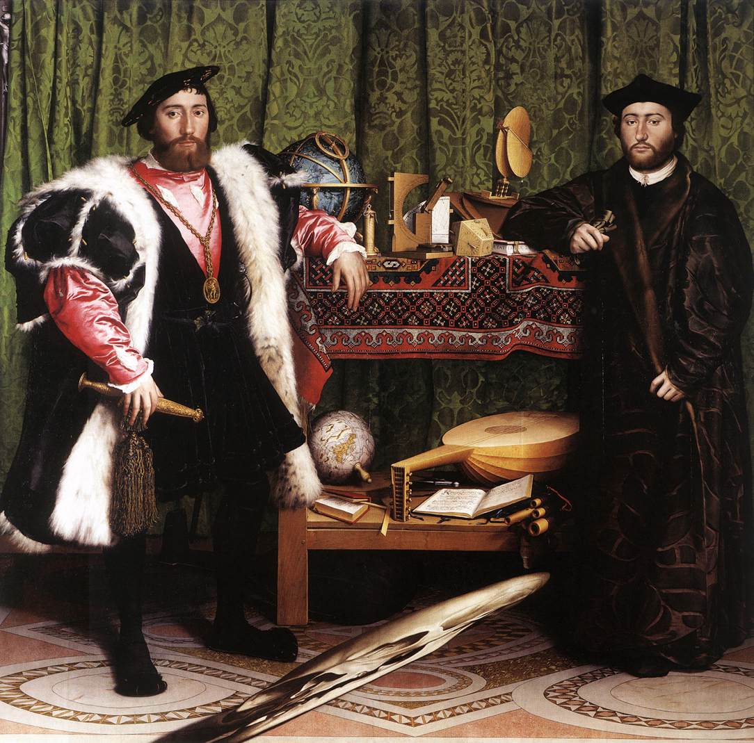
The Ambassadors (1533) is a painting by Hans Holbein the Younger in the National Gallery in London. I remember first learning about it in my AP Art History class in High School. I was drawn to both the intricate nature of the painting‘s near-photorealism and the anamorphic skull that obstructs the foreground. Today I was attempting to warp the skull to see it properly rendered and I realized that there was a nicely painted globe in the background. Well, actually, there is a lot more than just a globe in the background of this painting– there is also a beautiful celestial globe and numerous scientific instruments, but I will let you explore the painting on your own. Suffice it to say, this painting remains one of my favorites.

|| 3/26/2009 || 2:50 pm || 1 Comment Rendered || ||
YouTube videos of the “Do-Re-Me” dance in Antwerp’s Central Station
Last month I created a Facebook group called Washington Metropolitan Area Residents For A 24 Hour Metro. Each week or so I’ve been sending members of the group different subway related YouTube videos- ranging from Improv Everywhere’s Subway Art Gallery Opening to Toronto’s subway dance party. Last night I came across another iteration of the faux-flash-mob-that-decides-to-dance-in-a-train-station-meme and decided to share it with the group. It features 200 well-choreographed dancers getting down to a remix of Julie Andrews singing Do-Re-Me from the musical The Sound of Music in Antwerp’s Central Station. Similar to the efforts behind the T-Mobile video, I believe the motivation behind this video is related to the promotion of the Belgian theatrical version of “Looking for Maria” or “Op zoek naar Maria,” which is based on the Sound of Music.
Below is the behind the scenes video and two different perspectives of the dance:
+ MORE

|| 10/31/2008 || 11:51 am || Comments Off || ||
She’s got the sole of the city with SWIMS galoshes
I read about these stylish galoshes a little while ago, and saw the map on sole of the shoe, but I couldn’t find a high resolution version that showed the actual map. Yesterday I found it. SWIMS, a Scandinavian company known for making stylish galoshes, incorporates lots of great details both for practical and aesthetic reasons such as:
• Extra traction for slippery surfaces.
• The sole of each CitySlipper has the map of either New York, Paris, or Tokyo.
• Pull on/off grip and the soft siliconpad on the sides makes it very convenient.
• Flexible design to fit almost any heel height and thickness due to flexible material and construction.
• Protection for the delicate leather/suede sole of your shoe and the tip of the shoe against the elements.
• Low-Cut style is for shoes with bows and buckles.
The maps themselves definitely fall into the realm of aesthetics not cartographics, but ya know, I am a big fan of those kind of
maps.
Related Fashion Entries:
+ MORE

|| 10/23/2008 || 12:05 pm || 2 Comments Rendered || ||
You’re A Nation!
I was at a house party over the weekend and went to the bathroom to relieve myself. As I was unzipping my fly, I looked up and saw the map in magazine on top of the toilet and an old joke came into my mind: When you go into the bathroom you are an American. When you leave the bathroom, you are an American. What are you in the bathroom? Now the answer to the joke/riddle is funny (if you are in the 5th grade) and simple: European aka You’re a pee’in’ (get it?!)
I’ve been trying to take photographs of found maps with my camera and this one was too funny to pass up. By combining that lame humor with the fact that map in the magazine above shows most of the western hemisphere, I decided to switch out the word “‘peein” and add the word “nation,” hence, “Urination or You’re A Nation!” ….Rimshot…. Talk about taking the piss…

|| 6/3/2008 || 6:33 pm || 1 Comment Rendered || ||
Bicycle Freedom! [Vélib' in DC]
With Washington, DC about to begin the first bicycle sharing program in the United States, I’m posting some videos featuring the Parisian bike sharing service called Vélib’. The names in French is a combination of vélo liberté or vélo libre and in English it means free bicycle or bicycle freedom.
I think these YouTube videos are a fitting follow-up to my new bicycle freedom in Washington, DC :-)
I post more when I find them….
Related Bicycling Entries:

|| 3/1/2008 || 11:40 am || Comments Off || ||
Du Er Her
Du Er Her = You Are Here (in Danish)
About a month ago I was contacted by the author of the book “You Are Here: Personal Geographies and Other Maps of the Imagination.” She was interested in using one of my maps for her upcoming book (expect another posting in the not-so-distant future about this). One of my daily reads as of late is Copenhagen Cycle Chic. It’s a simple blog that shows photographs of women on bicycles in the Denmark’s capital city. Looking at the photographs everyday make me want to move to Copenhagen. The other day while I was looking through the author’s Flickr photostream I spotted the photo above and smiled.

|| 2/21/2008 || 10:26 am || Comments Off || ||
Map of the Languages of Europe
Following up yesterday’s posting about languages, I am posting this map I found on Wikipedia that shows where different languages are spoken throughout Europe. I find this type of map quite interesting to view, yet I feel it lacks one important cartographic aspect: overlap. Basically, the simplified map above does not show where multiple languages are spoken, rather only where the dominant languages are. By not including this important aspect we are given a nicely colored map, yet in reality there is a lot more merging of colors because there are geographies that have multiple languages spoken.
It’s too bad I don’t know Hebrew because
tonight’s exhibition will most likely include some Hebrew on maps of Israel.
#UPDATE – I have updated the map to the latest version on Wikipedia, which was made in February 25, 2009.
Related Europe Entries:
+ MORE

|| 6/18/2007 || 8:09 pm || Comments Off || ||
America as a Cloverleaf
View the original, interactive version, and legend:
This historic map mashup is courtesy of Heinrich Bunting (1545-1606) by way of the Yale University Map Library.
Originally the three cloverleaves were of Africa (South/Middle) , Europe (West/Left), and Asia (East/Right) and at the center was Jerusalem. You can read more about this map at the website Strange Maps.
My rendition is San Francisco’s Financial District (West/Left), the Saint Louis Arch (South), and Lower Manhattan (East/Right) and at the center is the rowhouse in Washington, DC where I reside at.
+ MORE
