The Daily Render

by

A Digital Scrapbook for the Past, Present, and Future

| FRONT PAGE | GEOSPATIAL ART | DC HISTORY / TIMELINE | NEWS | COLONIST | FOUND MAPS | FRACTALS |
| PHOTOGRAPHY | ANTIQUE | DESIGN | VIDEO | | CONTACT |

Brownsville Spheres
|| 3/17/2008 || 5:30 pm || Comments Off on Brownsville Spheres || ||

: rendered at 15,000 X 10,000 :
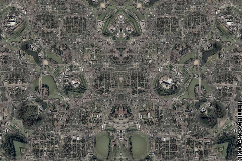
Brownsville Spheres.

Brownsville is the southernmost border town in the state of Texas. Similar to my “Ciudad Paso” maps, this map features land in both America (Brownsville) & Mexico (Matamoros, Tamaulipas) and literally focuses on border issues like immigration.

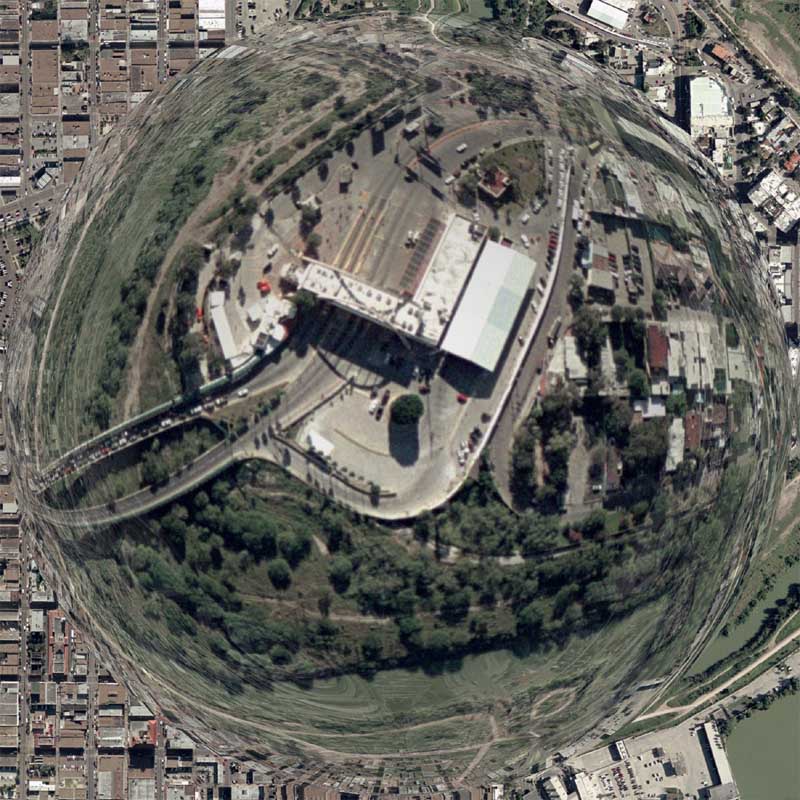
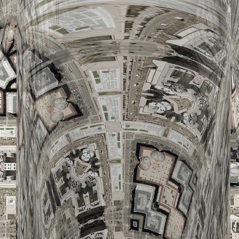
Using the same elements of Charlotte Spheres, I decided to make another version of this type of Lenz-influenced map. Unlike the previous version, which featured the spheres completely centered, I chose to move the spheres around to achieve a desired result.

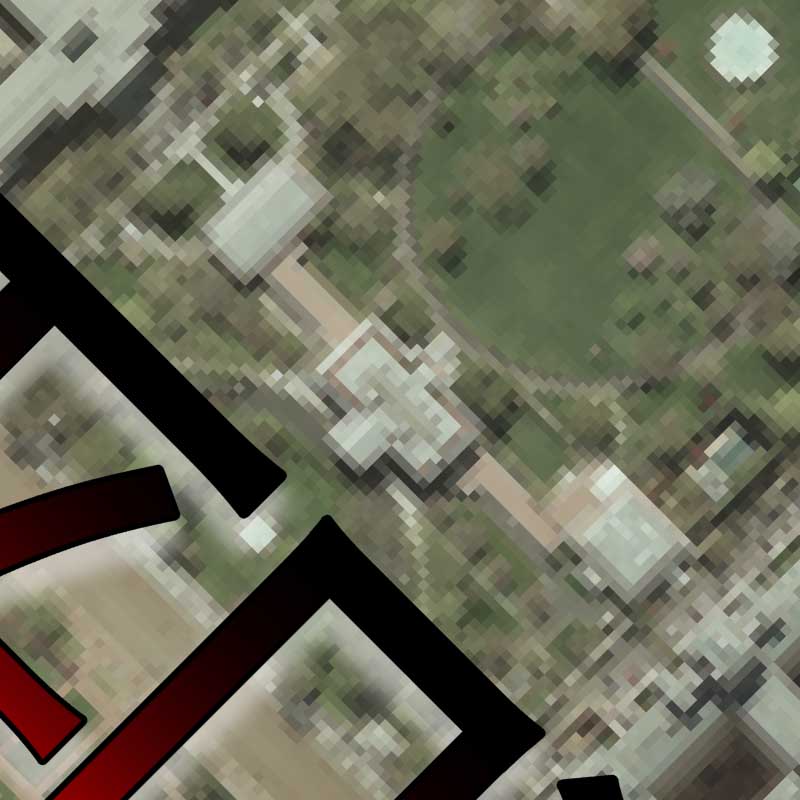
Specifically, I noticed that a few of the spheres (four to be precise) hovered over the border facility where cars are waiting in line (below) to cross into America/Mexico. If you look closely, you can see the border/bridge at 3 different spatial scales. This visual element is what I like the most about using the spheres in my maps because it forces your eye to move around the page to identify places where the geography is the same and where the scale is different. One drawback, however, is that I cannot accurately predict how much magnification the spheres will produce. This map, for example, was slightly overprojected (see the graininess below), but unless I am printing it at it’s largest size, its hard to tell the degree to which the imagery was overprojected. I chose to render the map at 15Kx10K instead of the normal 18Kx12K to allow for 3,000 pixels worth of magnification to take place, yet after looking at the results, I probably should have rendered it at 12Kx9K. Oh well, thats the beauty of trial & error; next one will be better.

View the Google Map of Brownsville, Texas.

View the rest of the details:

+ MORE


White House Peace
|| 3/13/2008 || 2:56 pm || Comments Off on White House Peace || ||

: rendered at 18,000 X 12,000 :White House Peace by Nikolas Schiller.

Similar to the Shanghai Map, this map uses Chinese characters as a decorative element. The source aerial photography of the White House was censored by the government before it was released to the public. I documented this about a year ago with my Lost Series project “The White House is off-limits to the public.” Unlike the Shanghai Map, I made a tessellation using the words for PEACE instead of placing the glyphs at the bottom. I was, however, thinking of revisiting this map in the near future and adding more text. As it is now, I think it’s somewhat plain, and deserves something else. I’m not sure what that ‘else’ is yet.

View the Google Map (which shows older imagery) of the White House.

View the rest of the details:

+ MORE


Union Station Quilt #3
|| 3/12/2008 || 2:44 pm || Comments Off on Union Station Quilt #3 || ||

: rendered at 18,000 X 12,000 :Union Station Quilt #3.

I find it quite interesting being able to see the difference between spatial scales when comparing the two previous Union Station maps. Since this map uses .16 meters per pixel aerial photography and the previous two maps use imagery that was .3 meters per pixel, you can quite easily see how much less I am now showing of the area around Union Station. Specifically, this map only shows the U.S. Postal Museum, Union Station, the Thurgood Marshal Federal Building, and the U.S. Securities and Exchange Commission.View the Google Map of Union Station in downtown Washington, DC.

View the rest of the details:

+ MORE


ordered last week: New Blaeu
|| 3/10/2008 || 9:25 pm || Comments Off on ordered last week: New Blaeu || ||

New Blaeu by Nikolas Schiller

Originally created last summer as “NOVA ET ACCVRATISSIMA TOTIVS TERRARVM ORBIS TABVLA [2007 Remix],” when this map was published in the December 14th issue of the Christian Science Monitor, the editors truncated the name and simply called it “New Blaeu.”

Last week I decided to update the map slightly by trimming the edges and doing some color correction. It’s being printed at 20″x16″ and preserved behind glass in in an ornate gold frame. I am also planning on framing some of the other antique maps I purchased recently to compliment this map. I think they’ll look really cool all hung together; the real old with the fake new.

View the other detail:

+ MORE


Scott Circle Quilt #2
|| 3/9/2008 || 9:10 pm || Comments Off on Scott Circle Quilt #2 || ||

: rendered at 18,000 X 12,000 :
Scott Circle Quilt #2 by Nikolas Schiller

Read more about Scott Circle in my previous entry.

View the Google Map of Scott Circle in downtown Washington, DC.

View the rest of the details:

+ MORE


Scott Circle Quilt
|| 3/8/2008 || 1:32 pm || Comments Off on Scott Circle Quilt || ||

: rendered at 18,000 X 12,000 :
Scott Circle Quilt by Nikolas Schiller

I am in the process of making hexagon quilt projection maps of all the major traffic circles in Washington, DC. I have most of the circles covered and intend on continuing this project as I acquire new imagery of Washington, DC. Of important note is that Dupont, Logan, Washington, and Scott circles all lie with the area that is censored in Google Maps. Also, this is one of the first maps that I’ve made in a few years that features National Geographic‘s headquarters. I will probably make a derivative map dedicated to National Geographic.

View the Google Map of Scott Circle in downtown Washington, DC.

View the rest of the details:

+ MORE


Federal Triangle Refraction
|| 3/6/2008 || 12:16 pm || Comments Off on Federal Triangle Refraction || ||

: rendered at 12,000 X 8,000 :
Federal Triangle Refraction by Nikolas Schiller

Lately I’ve been revisiting some of the elements from the Lenz Projection— specifically in the Charlotte Spheres, Pentagon Spheres, Grand Design Lenz Quilt, and Rochester Quilt #2. Today I decided to experiment a little more with aerial refraction. Using the 3rd derivative tessellation, originally used in Federal Triangle Quilt #4, I this created a visually engaging map. I like how the bars look very similar to my polar coordinate experiments. Specifically, I like the way that they imagery is curved and refracted. What I don’t like, however, is the way the shadows present themselves within the refraction. Since like bars are angled toward the viewer, they create a darker hue due to their internal shadows. The way around this is to decrease the angle of the bars, but in response to this, the imagery bends less. I will probably revisit this type of map in the future.

View the Google Map of Federal Triangle in downtown Washington, DC.

View the rest of the details:

+ MORE


Washington + Dupont Circle Quilt
|| 3/2/2008 || 11:43 am || Comments Off on Washington + Dupont Circle Quilt || ||

: rendered at 18,000 X 12,000 :
Washington + Dupont Circle Quilt by Nikolas Schiller

I decided to switch things up a bit with today’s rendering. I have become very efficient with most of the processes used to create my maps, which both makes them standardized and sometimes a bit too similar to each other (while paradoxically being different geographies). This map and probably the next few maps are going to be slightly different.

In order to have the most recent maps of Logan Circle, Dupont Circle, and Washington Circle look similar to each other, I would take the first derivative tessellation and overlay it on top of the tessellation that I was constructing. By adjusting the transparency, I can overlay the circles directly on top of each other which makes the subsequent map look nearly identical.

Normally, I simply delete the original tessellation when I have the two lined up perfectly, however in today’s map I chose to not delete the other map. Instead, I adjusted the transparency of Dupont Circle to 51% to show both geographies at once. The result is something that I wasn’t expecting, but am quite pleased with the results. I can see myself using this process again. It’s like a double exposure…

View the Google Map of Washington Circle in the Foggy Bottom neighborhood of Washington, DC.

View the Google Map of Dupont Circle in Washington, DC.

View the rest of the details:

+ MORE


Washington Circle Quilt #2
|| 2/29/2008 || 11:46 am || Comments Off on Washington Circle Quilt #2 || ||

: rendered at 18,000 X 12,000 :
Washington Circle Quilt by Nikolas Schiller

By using the exact same tessellation process, I was hoping that this derivative map would look similar to Dupont Circle Quilt 2005 #2 and Logan Circle Quilt #2. Alas, I must have not used the EXACT tessellation process because the circle looks slightly different, but I am still pleased with the result. I intend on making maps of the rest of the circles in Washington, DC.

View the Google Map of Washington Circle in the Foggy Bottom neighborhood of Washington, DC.

View the rest of the details:

+ MORE


Washington Circle Quilt
|| 2/26/2008 || 3:36 pm || Comments Off on Washington Circle Quilt || ||

: rendered at 18,000 X 12,000 :
Washington Circle Quilt

View the Google Map of Washington Circle in the Foggy Bottom neighborhood of Washington, DC.

View Details:

+ MORE


The Daily Render By
A Digital Scrapbook for the Past, Present, and Future.

©2004-2026 Nikolas R. Schiller - Former Colonist of the District of Columbia - Privacy Policy - Fair Use - RSS - Contact


::LAST 51 POSTS::

Fair Use


53 queries. 3.331 seconds.
Powered by WordPress

Photo by Charlie McCormick
Hello! Thanks for stopping by! My name is Nikolas Schiller. I am an American citizen currently living in New York City and working remotely to support structural change in Washington, DC.

This blog is my online repository of what I have created or found online since May of 2004. I've been on hiatus since 2018 but plan on contributing more content in the not so distant future.

If you have any questions or comments, please contact:

If you would like to use content found here, please consult my Fair Use page.

::THE QUILT PROJECTION::

Square
Square

Diamond
diamond

Hexagon
hexagon

Octagon
octagon

Dodecagon
Dodecagon

Beyond
beyond

::OTHER PROJECTIONS::

The Lenz Project
Lenz

Mandala Project
Mandala

The Star Series


Abstract Series
abstract

Memory Series
Memory

Mother Earth Series
Mother Earth

Misc Renderings
Misc

::POPULAR MAPS::

- The Los Angeles Interchanges Series
- The Lost Series
- Terra Fermi
- Antique Map Mashups
- Google StreetView I.E.D.
- LOLmaps
- The Inaugural Map
- The Shanghai Map
- Ball of Destruction
- The Lenz Project - Maps at the Library of Congress
- Winner of the Everywhere Man Award

::MONTHLY ARCHIVES::


@NikolasSchiller

::LOCATIONS & CATEGORIES::

  • 2004 Elections (2)
  • 2008 Elections (35)
  • 2014 Elections (4)
  • 2016 Elections (2)
  • ACLU (3)
  • Activism (287)
  • Adbusters (13)
  • Advertisements (33)
  • aerial photography (19)
  • Analysis (31)
  • Animals (30)
  • animated gif (7)
  • Animation (25)
  • Antique (104)
  • Apple (1)
  • Arabic (17)
  • Architectural Archeology (9)
  • Artomatic (25)
  • Astronomy (15)
  • Astrophotography (9)
  • Audio (2)
  • Awards (3)
  • Backpacking (2)
  • banner graphics (5)
  • Beat Google to the Map (56)
  • bicycle (23)
  • Birds-Eye View (5)
  • Blaeu (10)
  • Book Covers (7)
  • Bridge (10)
  • Building (15)
  • calendar (28)
  • calligraphy (6)
  • Capital (61)
  • Cars (18)
  • Cartography (74)
  • Cartoon (9)
  • Celestial (31)
  • Censorship (32)
  • Chinese (7)
  • Chronicling America (34)
  • Classroom (5)
  • Clothing (12)
  • Commentary (76)
  • Commissioned (27)
  • Credit Cards (3)
  • Crime (12)
  • Cyrillic Alphabet (1)
  • DAILY LINKS (30)
  • Dance (2)
  • DC History (93)
  • Design (102)
  • Digital Scrap (5)
  • Election (11)
  • ESA (3)
  • Facebook (19)
  • Fantasy (3)
  • Fashion (23)
  • Fast Food (2)
  • FBI (7)
  • Flag (15)
  • flickr (4)
  • Found Map (56)
  • French (9)
  • Gallery (54)
  • Gardening (25)
  • General (256)
  • George Bush (12)
  • GIS (69)
  • GMO Labeling (4)
  • Google (31)
  • Google AdSense (4)
  • Google AdWords (3)
  • Google Earth (28)
  • Google Maps (47)
  • Google Reader (4)
  • Google Streetview (8)
  • GPS (7)
  • Graffiti (5)
  • Greek (4)
  • Green (72)
  • Green Party (18)
  • Healthcare (15)
  • Highway (35)
  • Hiking (2)
  • Hipster (2)
  • history (151)
  • Holidays (10)
  • House Party (2)
  • Hubble Telescope (2)
  • Humor (88)
  • In The News (88)
  • Insects (2)
  • Interactive (74)
  • Interiors (4)
  • IP Trace (28)
  • Latin (22)
  • Law (15)
  • Lecture (11)
  • Legislation (19)
  • Library (21)
  • Library of Congress (66)
  • Location (1,018)
  • LOLMaps (3)
  • Mass Transit (6)
  • Memorandum (2)
  • meta-data (32)
  • Mobile Phone Applications (1)
  • Movie (3)
  • MrSID (4)
  • MSN (5)
  • Museum (5)
  • Music (48)
  • MySpace (6)
  • NASA (10)
  • National Archives (3)
  • News (182)
  • Obituary (2)
  • Oil (4)
  • Ornithology (4)
  • orthophotography (4)
  • OSCE (16)
  • Photography (134)
  • Poetry (18)
  • Portuguese (1)
  • postmodern (8)
  • QR code (9)
  • QTVR (4)
  • Radio (3)
  • Renderings (675)
  • RSS (3)
  • Seasons (12)
  • Sold (40)
  • Spanish (7)
  • Speech (5)
  • Sports (1)
  • Stadium (40)
  • statehood (94)
  • Statistics (2)
  • Stellarium (4)
  • Stereogram (1)
  • Street (21)
  • Street Art (10)
  • Submissions (5)
  • Tattoo (2)
  • Testimony (2)
  • time-lapse (19)
  • Torture (3)
  • Transportation (6)
  • TV (23)
  • Twitter (5)
  • University (41)
  • Update (24)
  • Vegetarianism (2)
  • Video (49)
  • Vimeo (18)
  • visualization (36)
  • Washington Critic (2)
  • Weather (19)
  • Web Crawler (9)
  • Wikipedia (14)
  • Wordpress (4)
  • Wordpress Upgrade (2)
  • World Wind (3)
  • Yahoo (6)
  • YouTube (113)
  • Zodiac (23)


  • thank you,
    come again!