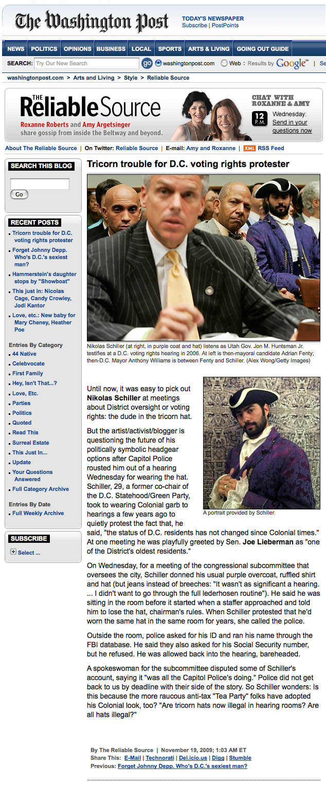
When I got back home from yesterday’s hearing I wrote my friend at the Washington Post the following e-mail:
+ MORE
| FRONT PAGE |
GEOSPATIAL ART |
DC HISTORY / TIMELINE |
NEWS |
COLONIST |
FOUND MAPS |
FRACTALS |
|
PHOTOGRAPHY |
ANTIQUE |
DESIGN |
VIDEO |
|
CONTACT |
The D.C. Colonist is featured today’s The Reliable Source column in the Style Section of the Washington Post
|| 11/19/2009 || 11:03 pm || Comments Off on The D.C. Colonist is featured today’s The Reliable Source column in the Style Section of the Washington Post || ||
When I got back home from yesterday’s hearing I wrote my friend at the Washington Post the following e-mail:
+ MORE
This Weekend: Westminster Playground Art Exhibition
|| 10/15/2009 || 2:21 pm || Comments Off on This Weekend: Westminster Playground Art Exhibition || ||
Sunday, October 18th, 2009, Noon until Sundown
913 Westminster Street NW, Washington, DC
You are invited to a special outdoor art exhibition at the Westminster Street playground. Neighborhood artists Chuck Baxter, George Smith-Shomari, and Nikolas Schiller, who all live on Westminster Street, will have their artwork display throughout the afternoon.
Crowned by the vibrantly-colored, 3 story mural titled “Community” by local artist Anne Marchand, the Westminster Playground is urban oasis that brings neighbors together and helps foster the mural’s namesake, community. The playground exhibition is free and open to everyone, is wheelchair accessible, and only two blocks from the U Street Metro station (10 Street exit). Since this exhibition is weather sensitive, please check Nikolas’s website, https://www.nikolasschiller.com/blog/ before noon o n October 18th if the weather looks bad. We hope to see you!
The Westminster Playground is located on the Northeast side of Westminster Street, a one block street between 9th & 10th and S & T Streets, NW, Washington, DC, 20001.
Chuck Baxter creates found object art from materials tossed in DC’ s gutters and alleys. For the past decade Chuck has built a reputation, in his own mind, as the D.C. area’s foremost collector of gutter gifts. He’s a U.S. Department of Veterans Affairs bureaucrat, a DC artist, and minimal director of his own life. Few of Chuck’s pieces hang in DC business and government offices, and in the homes of art collectors and friends around the world. “I have always felt the pull of throw-aways, and sought to invoke the world of junk as the natural medium for the urban artist.” His fascination with the flotsam of city life and the details of trash, such as broken glass, smashed plastic, crumpled paper, and lost toys, is the starting point for most of his pieces. The underlying compositional theme of his work draw from the common shapes and forms found in the gutter. Chuck currently resides in the Shaw where he simmers in his own private studio.
Member of MidCity Artists visit: https://www.MidCityArtists.com
George Smith-Shomari is an artist, professor and artistic consultant who’s artwork focuses on the Universal African Diaspora. A native of Brooklyn, New York, Professor Smith received his Bachelor of Fine Arts degree from Howard University and his Master’s with a specialization in printmaking and art education from Pratt Institute. In addition to teaching at the University of the District of Columbia, George Smith has taught in the DC Public School System and several museums in New York City. The artistic works of George H. Smith, have appeared in numerous one man and group exhibitions in museums, galleries, schools, colleges and universities throughout the United States and abroad.
For more information visit: https://www.shomariarts.com
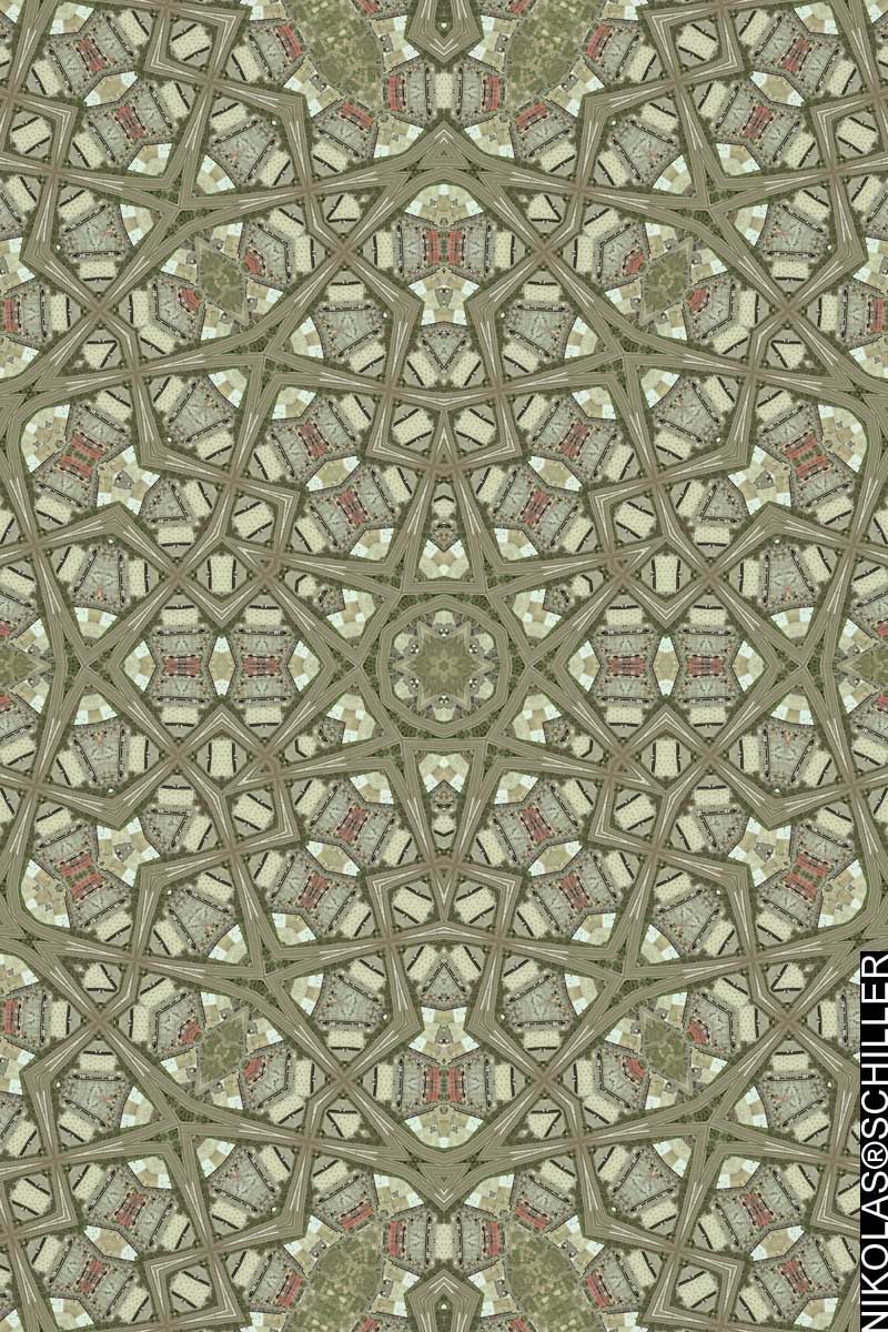
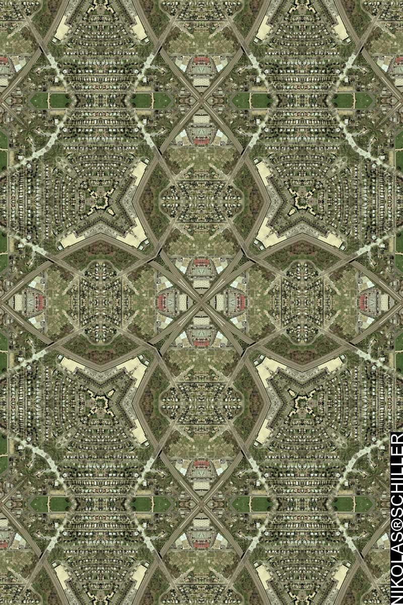
Nikolas Schiller is a digital artist who maps the territory between art & science. After studying geography & computer science at the George Washington University, in 2004 he began developing abstract geographic designs based on kaleidoscopic aerial photography and satellite imagery. In the years since, he has mapped nearly every major city in the United States, including each ward of Washington, DC. His unique maps have been featured on book covers, album covers, and are in the permanent map collections of the Library of Congress, British Library, New York Public Library, and the University of California, Santa Barbara. He is the two-time recipient of the DC Commission on the Arts and Humanities Young Artist Program Grant (2006 & 2008) and most recently had his artwork on display at Artomatic 2009 in Washington, DC and “Photocartopgrahies: the Tattered Fragments of the Map” in Los Angeles.
For more information visit: https://www.NikolasSchiller.com
(…and the weather is nice!)
Participating in my Monthly Maps Sale in 3 Easy Steps
|| 8/26/2009 || 11:08 pm || Comments Off on Participating in my Monthly Maps Sale in 3 Easy Steps || ||

Starting earlier this month those who are subscribed to my listserv were given the opportunity to purchase a map at the reasonable price of $100. I felt this was a great way to cheaply obtain the different maps I have created over the years. Since I have hundreds of maps to choose from, this monthly opportunity will last for years and ultimately become a great way to collect my maps.
Previously I used to point people to my ImageKind Store, but I wasn’t pleased with some of the cheap papers the maps were printed on, and have chosen to remove the middle man, so to speak, and have all the map purchases go directly through me. This way I can control the materials the maps are printed on, personally sign each map, and ensure the quality for each map that is produced.
For the month of August, the first Monthly Map, I chose was Washington Monument Quilt (above), which I first rendered on January 31st, 2006. Since the area around the Washington Monument was redacted in the 2005 USGS aerial photography, I felt it was a worthwhile piece to start with.
After sending out my initial e-mail about the offering, I had a friend contact me about purchasing the map and decided to document some of the steps involved in the process of ordering the maps through me….

Photo of the tube the map is shipped inside of.
You can either contact me about sending cash or a check or you can quickly & easily pay the $100 by credit card on my PayPal merchant account page. After I receive the payment, I will need your mailing address if you want the map mailed to you. If you live in Washington, DC, I can either mail it to you or meet you in person and hand-deliver the map. I’ve found it easiest to go through PayPal because it’s quick and safe.

Photo of the rolled up map next to the shipping tube
After I receive payment, I send the map to the printer. For the time being, my Monthly Map Sale is featuring 30″ x 20″ prints on Kodak PerfectTouch Paper. Throughout the last 5 years I’ve had the best results on this medium, both in quality of colors and durability of the paper. It’s also the same medium I used when I donated 8 maps to the Library of Congress in 2006. In about 3 days or less, I receive confirmation that the map has been printed and is in transit to me or you.

Photo of unrolled map of Washington Monument Quilt
I can have the map shipped directly to you as well (without signature, date, or label) for faster turnaround or I can have it shipped to my house. After the map arrives, I remove it from the shipping tube (above), carefully flip it over, label the name of the map, label the date it was originally rendered, label the date it was printed, and sign the map (below).
After this, I roll the map back up into the tube, add a little extra padding to ensure the map will not be damaged, then I bring it to the post office. Three days later it should be delivered to your mailbox. Or if the map is purchased locally, we can meet up and exchange the map in person.

Photo of the label, date, and partial signature
THATS IT! I think the whole process is pretty simple. In all this process takes about one or two weeks depending on the speed at which the payment is received and how long it takes for the map to be printed and shipped.
I think the hardest part of it all will be choosing which map to offer each month! Please contact me if you are interested in purchasing this month’s map or have suggestions for future Monthly Map offerings.
[Commissioned Map] National Gallery of Art Sculpture Garden Quilt – Tessellation #4 / Drafts #7 & #8
|| 8/22/2009 || 7:12 pm || Comments Off on [Commissioned Map] National Gallery of Art Sculpture Garden Quilt – Tessellation #4 / Drafts #7 & #8 || ||

A few days ago I started on a new commissioned map of the Sculpture Garden at the National Gallery of Art on the National Mall in Washington, DC. The client made it somewhat easier for me because they were interested in either a Hexagon Quilt Projection map (above) or an Octagon Quilt Projection map (below). Unlike the previous two drafts, today’s drafts feature a far-away view of the area immediately around the Sculpture Garden.
View the Google Map of the Sculpture Garden at the National Gallery of Art
Please contact me if you would like to have a custom map designed for your home, office, or as a gift for someone special!

[Commissioned Map] National Gallery of Art Sculpture Garden Quilt – Tessellation #3 / Drafts #5 & #6
|| 8/19/2009 || 6:42 pm || Comments Off on [Commissioned Map] National Gallery of Art Sculpture Garden Quilt – Tessellation #3 / Drafts #5 & #6 || ||

The other day I started on a new commissioned map of the Sculpture Garden at the National Gallery of Art on the National Mall in Washington, DC. The client made it somewhat easier for me because they were interested in either a Hexagon Quilt Projection map (above) or an Octagon Quilt Projection map (below). Like the previous two drafts, today’s drafts feature a close-up view of the area around the Sculpture Garden.
View the Google Map of the Sculpture Garden at the National Gallery of Art
Please contact me if you would like to have a custom map designed for your home, office, or as a gift for someone special!

Photo of the Sandy Spring Friends School Quilt Printed on Polyester Fabric
|| 8/7/2009 || 6:00 pm || Comments Off on Photo of the Sandy Spring Friends School Quilt Printed on Polyester Fabric || ||

I gave this map to the client Wednesday afternoon, but not before snapping a photograph of the final version of the map. I have to say that seeing a map on my website is a completely different experience than seeing one in person. When you are actually looking at the map, all the details come through, as opposed to viewing them on-line, where the map’s scale is reduced considerably. This map was printed at 60″ x 40″ on polyester fleece and I am quite happy how the printing turned out! I sincerely hope the final recipient enjoys it :-)
As always, send me a message if you interested in purchasing a map or having one commissioned for yourself or as a gift.
– [Commissioned Map] Sandy Spring Friends School – Tessellation One
– [Commissioned Map] Sandy Spring Friends School – Tessellation Two
– [Commissioned Map] Sandy Spring Friends School – Tessellation Three
– [Commissioned Map] Sandy Spring Friends School – Tessellation Four
– [Commissioned Map] Sandy Spring Friends School – Tessellation Five
– [Commissioned Map] Sandy Spring Friends School Quilt
+ MORE
Metro Crash Quilt #2
|| 6/29/2009 || 2:23 pm || Comments Off on Metro Crash Quilt #2 || ||
Continuing on the theme of my last map, I decided to focus on the merging of the two Metro trains for this version. To create this map I first sampled a portion of Metro Crash Quilt, then I used that portion to create an intermediate map (that I chose to not publish), which I then sampled again to create this fractal Hexagon Quilt Projection map. This process of recursive sampling allowed me to focus more and more on the portion of the map where the two train merge together. The result is a weaved pattern of train tracks and merging Metro cars; a far more intricate map than my previous version. What is lost, however, is the area around the crash site and the crash site itself, in their place are more trains and more train track. I have sampled a portion of this map and am in the process of seeing what a third iteration will look like.
View the Google Map of the crash site in upper Northeast Washington, DC.

View the rest of the map details:
+ MORE
Metro Crash Quilt
|| 6/27/2009 || 12:09 pm || Comments Off on Metro Crash Quilt || ||
As I stated before, I decided to make a map of the location of where the Metro crash took place. When preparing the imagery I did my best to include both the train and the exact site of the collision, but when it came to trying out different Quilt Projection designs, I found the Square Quilt Projection to have a very interesting line of symmetry– the Metro train itself.
While this map is derived from orthophotography, which essentially flattens out the terrain, the train’s laterally merging together on a line of symmetry creates a different viewing approach to the train. Since I cannot replicate the Metro train on top of another Metro train (nor would I really want to or even have access to the aerial photos of the crash itself), this line of symmetry approach offers a stylized (albeit sad) way to show the merger of two trains.
The aim of this map was to document the location of this tragedy, but I was able to add more than I expected to the final result; a simulated merger of two trains. Had there not been a random train passing through the area on that day in March of 2005, this map would be devoid of the subject of it’s creation and only show the location of the tragedy.
I am working on a second iteration of this map which should be ready shortly.
View the Google Map of the crash site in upper Northeast Washington, DC.

View the rest of the map details:
+ MORE
The National Archives Cross
|| 10/24/2008 || 1:38 pm || Comments Off on The National Archives Cross || ||

So far I’ve made two other crosses: Mount Pleasant Cross and Memphis Cross. I am pretty sure how to make these now and future maps of this type will be added to it’s own special category on the sidebar. The cross above was chosen out of about 8 different tessellations and within this map is the National Archives at the center of the cross (hence the name), the Federal Trade Commission, the Robert F. Kennedy Department of Justice Building, the Federal Bureau of Investigation, the Navy Memorial– which features a map of the western hemisphere (below), the Winfield Scott Hancock statue, the Grand Army of the Republic Memorial, and portions of the National Gallery of Art Sculpture Garden and the west building of the National Gallery of Art, which make the vertical and horizontal stripe.
For reference, click here to view the outdated Google Map of downtown Washington, DC.


+ MORE
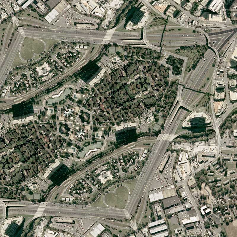
[Commission] Shirlington Quilt
|| 10/15/2008 || 6:16 pm || Comments Off on [Commission] Shirlington Quilt || ||

I’ve been working on this commissioned map for a few months now. It was originally going to be Paris, but we decided to it would be easier to make a map of their house. I spent some extra time transforming the nearby highway into a heart (below) to signify the love between the husband and wife. I think it looks beautiful :-) It will be placed in the client’s home, which is featured within the map.
View the Google Map of the Shirlington neighborhood of Arlington, Virginia.
+ MORE
©2004-2026 Nikolas R. Schiller - Former Colonist of the District of Columbia - Privacy Policy - Fair Use - RSS - Contact
::LAST 51 POSTS::
50 queries. 0.505 seconds.
Powered by WordPress


::THE QUILT PROJECTION::
Square |
Diamond |
Hexagon |
Octagon |
Dodecagon |
Beyond |
::OTHER PROJECTIONS::
The Lenz Project |
Mandala Project |
The Star Series |
Abstract Series |
Memory Series
|
Mother Earth Series
|
|
Misc Renderings
 |
::POPULAR MAPS::
- The Los Angeles Interchanges Series::MONTHLY ARCHIVES::
::LOCATIONS & CATEGORIES::