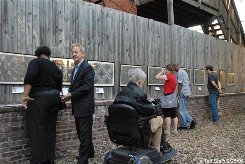
I was contacted by Daniel Tucker in January of this year to participate in his map archive. I thought it was a great idea so I offered my Pentagon Quilt #3 map. I received notification this week that the map archive starts its tour for the next two years with the exhibit called Experimental Geography. Here’s the blurb from the website:
EXPERIMENTAL GEOGRAPHY
Geography benefits from the study of specific histories, sites, and memories. Every estuary, land fill, and cul-de-sac has a story to tell. The task of the geographer is to alert us to what is directly in front of us, while the task of the experimental geographer, an amalgam of scientist, artist, and explorer, is to do so in a manner that deploys aesthetics, ambiguity, poetry, and a dash of empiricism. This exhibition explores the distinctions between geographical study and artistic experience of the earth, as well as the juncture where the two realms collide (and possibly make a new field altogether).
The manifestations of “experimental geography” (a term coined by geographer Trevor Paglen in 2002) run the gamut of contemporary art practice today: sewn cloth cities that spill out of suitcases, bus tours through water-treatment centers, performers climbing up the sides of buildings, and sound works capturing the buzz of electric waves on the power grid. In the hands of contemporary artists, the study of humanity’s engagement with the earth’s surface becomes a riddle best solved in experimental fashion. The exhibition presents a panoptic view of this new practice, through a wide range of mediums including interactive computer kiosks, sound and video installations, photography, sculpture, and experimental cartography.
The approaches used by the artists featured in Experimental Geography range from a poetic conflation of humanity and the earth to more empirical studies of our planet. For example, Ilana Halperin explores the intersection of personal, historic, and geologic time, as may be seen in the photograph of her stooping at the edge of natural hot springs to boil a small cup of milk. Creating projects that are more empirically minded, the Center for Land Use Interpretation (CLUI), a research organization, examines the nature and extent of human interaction with the earth’s surface, embracing a multidisciplinary approach to fulfilling its mission. Using pragmatic skill sets culled from the toolbox of geography, CLUI forces a reading of the American landscape (which includes traffic in Los Angeles, submerged cities, and the broadcast towers in the San Gabriel Mountains) that refamiliarizes the viewer with the overlooked details of their everyday experience.
Experimental Geography is curated by Nato Thompson, curator and producer at Creative Time in New York, and is accompanied by an illustrated catalogue.
Featuring:
Francis Al
AREA Chicago
The Center for Land Use Interpretation (CLUI)
the Center for Urban Pedagogy (CUP)
kanarinka (Catherine D’lgnazio)
e-Xplo
Ilana Halperin
Lize Mogel
Multiplicity
Trevor Paglen
Raqs Media Collective
Ellen Rothenberg
Julia Meltzer and David Thorne
Spurse
Deborah Stratman
Daniel Tucker, Organizer, The We are Here Map Archive < --- Hi!
Alex Villar
Yin Xiuzhen
Featured in Daniel Tucker’s We are Here Map Archive:
1. Bill Rankin “My cities” 1978-2004
2. Bill Rankin “The United States” 2003-2007
3. Counter Cartography Collective “Disorientation Guide” 2006
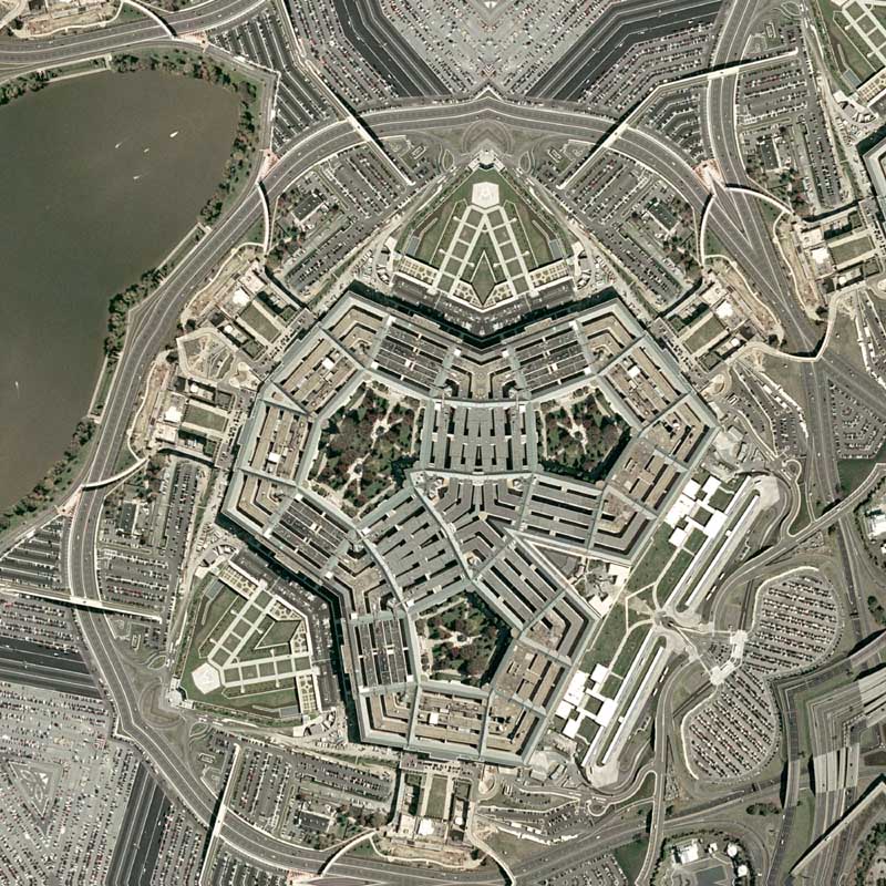
4. Nikolas R. Schiller “Pentagon Quilt #3” 2007
5. Ashley Hunt “Prison Map” 2003
6. Friends of William Blake “The People’s Guide to the RNC” 2004
7. Subrosa “Biopower Unlimited” 2002
8. Ecotrust Canada “Statement of Intent Boundaries” 2008
9. NYC Indypendent “Threat to Peace”
10. Repohistory “Circulation” 2000
11. Lize Mogel and Dario Azzellini “The Privatization of War: Colombia as Laboratory and Iraq as Large-Scale Application” 2007/2008
12. Beehive Design Collective “FTAA” 2003
13. Jeffrey Warren “Armsflow” 2006
14. Center for Urban Pedagogy “Cargo Chain” 2008
15. Temporary Travel Office “Contaminating the Preserve” 2008
16. Hackitectura (Pablo de Soto, Jose Perez de Lama osfa, Marta Paz sweena), Indymedia Estrecho and collaborators “Tactical Cartography of the Straits” 2004
17. Ayreen Anastas and Rene Gabri “Fear is Somehow Our For Whom? For What? and Proximity to Everything Far Away” 2006
18. The Los Angeles Urban Rangers “Malibu Public Beaches” 2007
19. The Los Angeles Urban Rangers “Los Angeles Urban Rangers Official Map and Guide” 2004
20. The Los Angeles Urban Rangers “LA County Fair” 2006
21. The Institute for Infinitely Small Things “City Formerly Known As Cambridge”
22. Amy Franceschini “Silicon Valley Superfund Sites” 2006
23. Amy Franceschini “Intentional Communities in Silicon Valley” 2008
24. Adriane Colburn “Whose On Top (race to the pole, part two)” 2008
25. Bureau d’études “World Government” 2005
26. Grupo de Arte Callejero “Aqui Viven Genocidas”
There will be a catalog for the exhibition that will be published by Melville House Books. I look forward to getting a copy when it comes out.
The tour starts next month and has dates that are still available. I would like for it to come to Washington, DC! :-)
Exhibition Itinerary
Richard E. Peeler Art Center , DePauw University, Greencastle, Indiana
September 19 – December 2, 2008
Rochester Art Center, Rochester, Minnesota
February 7 – April 18, 2009
The Albuquerque Museum, Albuquerque, New Mexico
June 28 – September 20, 2009
AVAILABLE
October 2009 – January 2010
Colby College Museum of Art, Waterville, Maine
February 21 – May 30, 2010
AVAILABLE
June – August 2010
Click on the detail of Pentagon Quilt #3 below to view the rest of the map:
Related Virginia Entries:
+ MORE


Getting to know Mr. SID
|| 1/7/2008 || 3:13 pm || Comments Off on Getting to know Mr. SID || ||
Screen grab from the Library of Congress which DOES NOT list Graphic Converter as an option…. yet?
For the last few years I’ve found the file format Mr. SID to be the bane of my cartographic explorations. When I’d see a map available in the MultiResolution Seamless Image Database format, it meant I’d have to keep looking for other maps. Conversion of the Mr.SID format on a Macintosh had kept the maps locked away in an obscure file format; smiting me.
In my opinion, one of the worst decisions that the Library of Congress made was the choice to use the Mr.SID file format for their on-line maps. First off, its a proprietary compression algorithm patented by a company that is motivated by profit, not by the intent of furthering academic research. This means that any software maker originally had to get a license (pay) to use it. This resulted in only a few programs being written that can convert the file type. Worse is that there are even fewer Macintosh-based programs that can convert these files. The patent owner’s website offers only one Macintosh product and does not allow the rendering of the map at it’s full size. As in, I could only export sections of the original map, which makes the reader useless. Secondly, the file type is in itself “an American Memory,” because its not widely used anymore. It made sense to use it originally- it saved server space because of the high compression algorithm, but now server space is relatively cheap. Today only people who use high-end GIS software use Mr.SID formated imagery, and since most of this software only exists on PCs, there has been little cross platform support. Lastly, for any maps to be used by an image editing program, the map must first be converted out of the Mr.SID format and converted into another filetype (.jpg, tiff, etc.). This means that for every map that is available on the Library of Congress website, I have to spend 15 minutes converting it to a useful format.
Over the weekend I discovered that there is *one* program for Macintosh that can convert this file type: Graphic Converter. I also discovered that the newsest version (the Universal Binary, which I downloaded last summer) did not handle Mr.SID. Instead, I had to download an obsolete version (Graphic Converter for PowerPC) to convert this arcane format! So for the last 7 months I had been unable to convert any Mr.SID formatted map, but now I can, and I’m very excited about the new possibilities this opens up (literally hundreds of maps are now within virtual reach! The Library is only a few blocks away, but the digitalization is just as important.).
I sincerely hope the Library of Congress updates the page above to list Graphic Converter as one of the programs that can convert Mr.SID formatted maps. This software program is already listed for use with other media on the same Library of Congress webpage. Also of note, is that Graphic Converter can also convert JPEG2000 encoded maps.