After hours of coding & geocoding, my first Google Map Mashups are ready… for some reason it only works with Firefox…Â I’ll try to fix this!
|
|
|
| FRONT PAGE |
GEOSPATIAL ART |
DC HISTORY / TIMELINE |
NEWS |
COLONIST |
FOUND MAPS |
FRACTALS |
|
PHOTOGRAPHY |
ANTIQUE |
DESIGN |
VIDEO |
|
CONTACT |
Google Map Blog Entry Mashups – DC & America
|| 4/17/2006 || 12:42 pm || Comments Off on Google Map Blog Entry Mashups – DC & America || ||
After hours of coding & geocoding, my first Google Map Mashups are ready… for some reason it only works with Firefox…Â I’ll try to fix this!
|
|
|
DC Area Farmers Markets
|| 12/26/2005 || 11:00 pm || Comments Off on DC Area Farmers Markets || ||

This evening I made the first layer for an ongoing mapping project I’ve tasked myself to, “SUSTAINABLE DC MAP”
If you have Google Earth, cut & paste this link as new network connection, and zoom into DC.
If you don’t have Google Earth, you can see two screen shots I took, here & here.
I have going to have a planting party this spring… details tba
Remember, January 5th, 7pm, UDC & me :)
Related Google Earth Entries:
Star Series – BETA
|| 10/30/2005 || 11:46 am || Comments Off on Star Series – BETA || ||
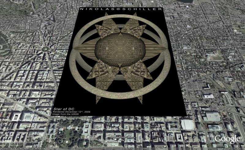
Beta release of the Star Series Image Overlay KML file for Google Earth.
Click here to download the zipped up KML file
Instructions:
Unzip the file, drag starseries.kml file to your desktop, and double click on it to lauch Google Earth
Once loaded into Google Earth, the layer will download the maps from the Star Series hosted on my website. On the Places Panel the folder titled “Star Series” will be placed. Clicking on the triangle next to the folder you can expand and collapse the contents of the folder. By clicking on the “Send Comment” link, the blog entry in which the map is referenced will load up in the Google Earth web browser allowing you to leave a comment on my blog. By adjusting the transparency of the map overlay, you can find the area on the ground which was as a guide.
The Alpha release will have icons instead of overlays to facilitate the navigation of my maps. Within each icon will be a link for the overlay of the map.
Known Issues:
Due to large size of the maps, Google Earth might slow down considerably after they are loaded.
Google Earth’s browser is based off of Internet Explorer and my website does not show up as how I’d like it to.
Please provide me with feedback!
Confluence Project meets Google Earth
|| 10/13/2005 || 8:24 am || 2 Comments Rendered || ||
After being so impressed by the kind words and excellent recap of my first confluence, I decided on a whim late Thursday night (early this morning) to respond to Joseph’s generosity by geocoding his 86 different confluences using Google Earth.
Already listed on the Confluence website was Joseph’s previous confluences, so all I had to was manually cut & paste each confluence into Google’s search bar and the program would take me to the location. This proved to be somewhat more time consuming because there is a bug in Google Earth which does not allow the ASCII code for degree° to be used when searching. This forced me to paste the coordinates, then go into the search box and delete the degree character.
After being flown to the confluence, I clicked on the icon to add a placemark and within the placemark I cut pasted the confluence URL, the date Jospeh visited, and the location’s approximate location. This way when someone clicks on the placemark, they are given the option of viewing Joseph’s pictures and remarks. With Google Earth’s embedded web browser this hyperlinking works excellently because you can see the on-the-ground photos alongside the overhead aerial & satellite imagery. This works very similar to my “E St. Risk Analysis” flash animation I made at GWU.
My favorite aspect of this little Google Earth project is the ability of this to be used for learning and pedagogical development. Essentially, I’ve wanted to make a learning tool for the program since Google Earth came out, but there hasn’t been an opportunity yet for me to do so. What I’ve created is a fun, inquiry driven, learning module for Google Earth which teaches the basics of thinking spatially about latitudes and longitudes.
Directions: Load the layer I made (link below) in Google Earth and go to the menu, click on View –> Lat/Long Grid, you can see how his travels lineup perfectly with the latitudes and longitudes on the surface of the earth. You can the go one step further by clicking on embedded Confluence URLs to see the temporal aspects of his visit and how they relate to the time when the aerial & satellite image was taken.
If you have Google Earth installed on your PC, click save target as, and download the layer “JKconfluences.kml” Then open it up in Google Earth and have fun!
I’d love feedback!
It’s Up – Check it Out!
|| 10/7/2005 || 6:37 pm || Comments Off on It’s Up – Check it Out! || ||
This print was displayed at MOCA DC/A&M Gallery
Located at 1054 31st St., NW, Canal Square
Hours: Wed, Thurs, Fri, Sat – 1-6pm Until October 28th, 2005
Jefferson Mandala – signed 30X20 Framed Kodak PerfectTouch Print

Ball of Destruction
|| 9/29/2005 || 9:00 pm || 1 Comment Rendered || ||
The Inaugural Map Recap
|| 3/23/2005 || 5:12 pm || Comments Off on The Inaugural Map Recap || ||
I just got the AWStats analysis back from the Inaugural Map IP logs… All I can say is WOW! I am going to be posting the HTML results on my website later tonight…. It looks like another analysis of the IP logs is needed for some of the IPs that didn’t resolve, so there might be some updated content tomorrow as well…..144,000 domain names takes a long while to analyze!….
 |
“The Inaugural Map”
Designed to help coordinate visitors coming to Washington, DC to celebrate the second inauguration of George W. Bush. InauguralMap.com was featured the front page of Michael Moore’s website and mentioned on the Drudge Report. In it’s one month on-line, InauguralMap.com recieved 147,681 hits and 42,155 unique visitors. |
More Bush than you ever want to see…
|| 2/13/2005 || 8:00 pm || Comments Off on More Bush than you ever want to see… || ||

Happy Valentines Day Mr. President
new GIS of my hood
|| 12/14/2004 || 11:46 pm || Comments Off on new GIS of my hood || ||

Like a true dork, I spent the evening remaking an older GIS of my neighborhood into a newer one . I used more recent imagery from the USGS and added popular destinations around where I live. I think its pretty cool to be able to give people interactive directions to your house….. and since we are having a party this weekend (below), why not send future guests a link? Makes sense to me, but then again, I just spent 4 hours remaking something only dorks will use. Time to go to Ben’s Chili Bowl (#3)
200 megapixels – wtf!
|| 9/12/2004 || 1:50 am || Comments Off on 200 megapixels – wtf! || ||
©2004-2023 Nikolas R. Schiller - Colonist of the District of Columbia - Privacy Policy - Fair Use - RSS - Contact
::LAST 51 POSTS::
58 queries. 0.724 seconds.
Powered by WordPress


::THE QUILT PROJECTION::
Square |
Diamond |
Hexagon |
Octagon |
Dodecagon |
Beyond |
::OTHER PROJECTIONS::
The Lenz Project |
Mandala Project |
The Star Series |
Abstract Series |
Memory Series
|
Mother Earth Series
|
|
Misc Renderings
 |
::POPULAR MAPS::
- The Los Angeles Interchanges Series::MONTHLY ARCHIVES::
::LOCATIONS & CATEGORIES::


